Jadigenahalli

Last updated

Jadigenahalli
village in Hosakote taluk
Namma jadigenahalli.png
Namma Jadigenahalli poster
India Karnataka location map.svg
Red pog.svg
Jadigenahalli
Location in Karnataka, India
Coordinates: 13°03′08″N77°51′09″E / 13.05222°N 77.85250°E / 13.05222; 77.85250
countryFlag of India.svg  India
State Karnataka
District Bangalore Rural
Taluk Hoskote
Elevation
920 m (3,020 ft)
Population
 (2011)
  Total1,977
Languages
  Official Kannada
Time zone IST
  Summer (DST) UTC+5:30
PIN
562114
Area code 91-80
Vehicle registration KA53
Lok Sabha constituency Chikkaballapura
Vidhan Sabha constituency Hoskote

Jadigenahalli is a village in the southern Indian state of Karnataka. It is situated in the Hoskote Taluk of the Bangalore Rural district, 7 [1] kilometers from Hoskote and 30 kilometers from Bangalore. The village is also one of the hobli's [2] of the taluk Hoskote and 69 [3] villages come under Jadigenahalli hobli. The village of Jadigenahalli is well-known for housing the Sri Kalabhairaveshwara temple.

Contents

History

Jade Muneshwara Jade Muneshwara.jpg
Jade Muneshwara

Jadigenahalli village is named after a holy lord known as Jade Muneshwara and is located on Saptamatrika Hill.

Demographics

As of 2011 India census, [4] The village's overall geographic area is 419.15 hectares, as measured by the census. In Jadigenahalli, there are 1,977 residents, 1,010 of them are male and 967 female. 71.88% of people in the village of Jadigenahalli are literate, including 79.41% of males and 64.01% of women. In the Jadigenahalli village, there are around 449 houses.

The official and most often spoken language in the community is Kannada. Several of the village's residents also speak Tamil.
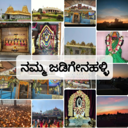
Culture

Jaatre 2023 Jadigenahalli jatre.png
Jaatre 2023
Deepotsava Jadigenahalli Fair.jpg
Deepotsava
Jaatre Jadigenhalli Jatre.png
Jaatre

A quarterly fair [5] honoring the deity Sri Karagaparameshwari is held in the village, typically in April or May once every nine or twelve years. The fair is said to have begun in 1950 as a result of plague and cholera diseases that were prevalent in the villages at the time. The fair was inaugurated by walking around the village for nine days without shoes or vehicles. Accordingly, the fair that began on that day was held in this manner once every 9 years and even today, people still observe the same customs. When the last fair took place in April 2023, the villagers observed a rigorous fast during which they did not wear sandals for nine days in the sweltering sun. [6] In addition, the villagers prohibited outsiders from visiting the village during the nine days of the fair held there. Once in 9 or 12 years, abhisheka and flowers, specifically Jasmine, are offered to the goddess Karagaparameshwari. Once Abhishekam and Jasmine's decoration is done, a procession throughout Jadigenahalli and the goddess karagaparameshwari reaches Kalabhairaveshwara temple. Poojas are performed to her in the temple after taking her back to the temple. This same process continues for one whole month, that is, from one new moon day to another new moon day. A total of 12 villages take part in this procession. On the last day, the villagers take her to the hill known as Saptamatrika Betta. Here Saptamatrika and Lord Jade Munshwara’s temple is located. After witnessing the pooja on the hill, she finally returns to her temple, the locals slaughter a large number of sheep in front of the temple.

The village also has an annual fair in April, often before Bengaluru Karaga, where locals offer decorated lamps (Deepotsava) to nine goddesses, beginning from Ugadi and terminates on Ramanavami.

There are numerous temples in the village, Sri Kalabhairava Temple, one of them, is the most well-known. Sapthamatha Temple, another well-known temple, is situated on a hilltop. In addition to these, there are several additional temples in the village, including the karagaparameshwari temple, the Sri Abhaya Anjenaya Swami Temple, the Muneshwara Temple, the Sri Karibasaveshwara Temple, the Yallamma Temple, the Eshwara Temple, the Om Shakti Temple, Kadmalleshwara temple and many others.

Climate

Jadigenahalli is located at 13°03′N77°51′E / 13.050°N 77.850°E / 13.050; 77.850 . [7] It has an average elevation of 920 [8] meters.

[9] The village has a tropical climate. According to the Köppen-Geiger classification of climates, this is a tropical wet and dry climate or Aw. Here, the average temperature is 22.9 °C (73.3 °F). There is roughly 903 mm (35.6 inches) of precipitation annually. The summers here have a good deal of rainfall, while the winters have very little.

The village is located in the northern hemisphere, to be precise. Here, summer lasts from late June until early September. The summer months are June, July, August, and September.

Sri Kalabhairaveshwara Temple Jadigenahalli

Kalabhaireshwara temple Kalabhaireshwara temple jadigenahalli.jpg
Kalabhaireshwara temple
Burning of Ash Gourd lamp at Kalabhaireshwara temple Kalabhairava temple jadigenahalli.jpg
Burning of Ash Gourd lamp at Kalabhaireshwara temple
Sri kalabhaireshwara temple Sri kalbhaireshwara temple Jadigenahalli.jpg
Sri kalabhaireshwara temple

The temple remains open only on special occasions(festivals) and on Ashtami, which falls on the eighth day after Amavasya. Every month on Astami, thousands of worshippers come here to worship the deity by lighting an ash gourd lamp during Rahu Kala.

Related Research Articles

<span class="mw-page-title-main">Bangalore Urban district</span> District of Karnataka in India

Bangalore Urban district is the most densely populated of the thirty-one districts that comprise the Indian state of Karnataka. It is surrounded by the Bangalore Rural district on the east and north, the Ramanagara district on the west and the Krishnagiri district of Tamil Nadu on the south. Bangalore Urban district came into being in 1986, with the partition of the erstwhile Bangalore district into Bangalore Urban and Bangalore Rural districts. Bangalore Urban has three taluks : Bangalore City, Yelahanka and Anekal. It has seventeen hoblies, 872 villages, eleven rural habitations, five towns, one tier-three city and one tier-one city, administered by ninety-six Village Panchayats , ninety-seven Taluk Panchayats , five Town Municipal Councils (Purasabes), one City Municipal Council (Nagarasabe) and one City Corporation .

<span class="mw-page-title-main">Hassan, Karnataka</span> City in Karnataka, India

Hassan is a city in the southern part of the Indian state of Karnataka. It is the headquarters of Hassan district. The city is situated midway between Bangalore and Mangalore on National Highway 75.

Malur is a town and taluk headquarters in Kolar district of the Indian state of Karnataka. It is 30 km from Kolar, the district headquarters, and about 25 km from Bangalore. It is accessible from Bangalore by road and railways. The Chennai Central-Bangalore City line passes through Malur, with trains to various parts of India, including Tirupati, Chennai, Kochi, Trivandrum, Patna and Calcutta.

<span class="mw-page-title-main">Arsikere</span> City in Karnataka, India

Arsikere is a city and taluka in the Hassan district in the state of Karnataka, India. It is the second largest city in Hassan district, demographically. Arsikere city municipal council consists of 35 wards. This region is known for its coconut production and is also called Kalpataru Nadu. Arsikere Junction is a major railway junction in the South Western Railway which links Mangalore and Mysore to North Karnataka and a central place for tourists who visit nearby places that do not have rail access, such as Belur, Halebidu and Shravanabelagola, Harnahalli, and Kodimata.

<span class="mw-page-title-main">Avani, Kolar</span> Village in Karnataka, India

Avani is a small village in Mulabaagilu taluk, Kolara district in Karnataka, India, about ten miles from Kolar Gold Fields. The village is located at 32 km from Kolara, the district centre and 13 km from Mulabaagilu, the Taluk headquarters. It is a popular location for rock climbing.

<span class="mw-page-title-main">Holenarasipura</span> Town in Karnataka, India

Holenarasipura is a town and taluk in Hassan district of Karnataka. The town is situated on the banks of the Hemavati, one of the tributaries of the Kaveri.

<span class="mw-page-title-main">Kanakapura</span> City in Karnataka, India

Kanakapura is a city in the Ramanagara district of Karnataka on the banks of the Arkavathi river and the administrative center of the taluk of the same name. Kanakapura is largest cocoon silk producer in India. River Cauvery flows around 21 km in Kanakapura Taluk.Previously belonged to Bangalore Rural District. It was formerly the largest constituency in the country. (1,553 km2 [600 sq mi]). It is located among the lush green forests of the state of Karnataka. The town is a tourism hotspot and an often visited tourist favorite in the entire state of Karnataka, as it has something for everyone ranging from avid trekkers to history buffs and wildlife enthusiasts. The forest area in this taluk is very wide and about half of the Bannerghatta National Park is located in our Kanakapura area. Kodihalli wildlife range and harohalli wildlife range its division. The Kaveri Wildlife Sanctuary consists of two main zones namely the Sangam Wildlife range, the Muggur Wildlife range

<span class="mw-page-title-main">Hoskote</span> City in Karnataka, India

Hoskote is a taluk or city in Bangalore Rural District, India. Headquartered at the Hoskote town, it consists of five hoblis - Kasaba, Anugondanahalli, Jadigenahalli, Nandagudi and Sulibele. There are 294 villages in Hoskote taluk including the 5 hoblis. Also famous for Dum Biriyani's which is unique in taste.

<span class="mw-page-title-main">Sakleshpur</span> Town in Karnataka, India

Sakleshpur, Sakleshpura or Sakleshapura is a hill station town and headquarters of Sakleshpur taluk in Hassan district in the Indian state of Karnataka.

<span class="mw-page-title-main">Siddapur taluk</span> Taluk in Karnataka, India

Siddapur Taluk is the destination of world famous Jog Falls. It is a part of Uttara Kannada district, Karnataka, India and is located in the midst of forest areas of Western Ghats and it is also a part of Malenadu. The taluk is full of greenery, hills and arecanut gardens developed in the valleys’. The taluk headquarters is Siddapur. Sirsi is the nearest city,

<span class="mw-page-title-main">Channarayapatna</span> Town in Karnataka, India

Channarayapatna is a town and Taluk headquarters in Hassan district of Karnataka, India. It lies on the Bangalore-Mangalore National Highway-75 in Karnataka, India. Jain pilgrimage Shravanabelagola is a famous site in the taluk. Channarayapatna has major railway connection from Bengaluru to Mangaluru, Karwar and Mysuru.

Neraluru is a village in Anekal taluk, Bangalore urban district, India. It is around 28 kilometers from Bangalore and 10 kilometers from Hosur, Tamil Nadu. The nearest mofussil towns are Attibele and Chandapura, both of which are within a 5 kilometer radius of Neralur. Electronics City, one of India's largest Information Technology parks, is around 10 kilometres from the village. A few of the villages which share its boundaries with Neralur are - Guddahatti, Balagaranahalli, Lakshmisagara, Old Chandapura, Thirumagondanahalli, Bandapura, Yadavanahalli and Bendaganahalli. Kannada is the most widely spoken language in the village.

Korwar is a village in the southern state of Karnataka, India. Sri Ksethra Korwar was initially called Kokilapur. It is located in the Devar Hippargi taluk of Bijapurdistrict in Karnataka. It is famous for Lord Hanuman temple, called as Korawareshwara. It comes under Korwar Panchayath. It belongs to Belgaum Division. It is located 64 km towards East from District headquarters Bijapur and 541 km from state capital Bangalore. Korwar Pin code is 586120 and postal head office is Korwar. Kannada is the Local Language here.

Neermanvi is a village in the southern state of Karnataka, India. It is located in the Manvi taluk of Raichur district in Karnataka.

Koligudda is a village in the Raybag Taluk of the Belgaum district in Karnataka, India. It is situated 123 kilometers northeast of Belgaum, between the Athani-Gokak road.

Kammanahalli is a small village located in Tumkur District, Turuvekere Taluk, Mayasandra Hobli and Vittalapura Post in India's Karnataka State. The village is about 12 km from Yadiyur which is famous for the Lord Siddalingeshwara Temple and is about 100 km from Bangalore.

Tubagere, is a Town and Grama Panchayat in Bangalore Rural district in the state of Karnataka, India. Tubagere in the native Kannada. Population of 2,199. This is a major agricultural hub near Doddaballapur. It is seen as a model town Center's Rural Bio-Resources Complex Project. Many farming families in 51 villages of Tubagere Hobli in Doddaballpur taluk have been benefited by the Bio-Resources Complex Project that has been launched on a pilot basis in Tubagere Hobli by the National Bio-Resources Development Board of the Union Government. The aim of the project is to increase the income of farmers by four times in five years starting from 1 April 2005, through reduction of the cost of cultivation and crop diversification. They hope it will put an end to the trend of farmers’ suicides and also the mass desertion of agriculture by farmers.

<span class="mw-page-title-main">Devimane Ghat</span> Village and hill station in Malenadu, Karnataka, India

Devimane is a hill station and high-altitude village in Sirsi taluk of Malenadu region in Karnataka, India. The road to reach the village is named Devimane Ghat, and lies in NH 766E ultimately connecting Malenadu city Sirsi and Karavali town Kumta. Being under the lush forest zone in Uttara Kannada District, it consists of 10 hairpin curves with a well-engineered road that reduces the risk of accidents. The road's elevation ranges from 25 to 567 metres. A temple of Goddess Durga Devi is at the beginning of the road at elevation 429m. The ghat section was named after the temple, "Devimane", meaning "the home of goddess Devi". There are 5 hairpins curves between Devimane Temple and Sampakhanda.

Yagati is a hobli in the southern state of Karnataka, India. It is located in the Kaduru taluk of Chikmagalur district.

Channarayapatna Taluk is one of the eight taluks of Hassan District, Karnataka, India. Channarayapatna town, being the taluka headquarters, lies on the Mangalore - Bangalore National highway 75 in Karnataka, India. Its popularity can be attributed to its historical and religious significant, coconut farming, sugar and also to its fields of literature, culture, religion etc. Now it is growing predominantly towards improvements in the modern era. The Taluk Office, Channarayapatna is located off the Bangalore-Mangalore highway in Channarayapatna town. The office is housed in the royal & majestic Mini Vidhana Soudha. In addition to the Taluka office, it also houses the Sub-Registrar office, Sub-Treasury office & Labour Inspector offices. The Taluk Office is headed by the Tahsildar who is of KAS cadre. They include Shirastedars, Deputy Tahsildars, Revenue Inspectors, FDAs, SDAs & Village Accountants. The Tahsildar also heads survey section which has survey supervisors, surveyors, Band Jawans, Licensed Surveyors besides managing food & civil supplies section, which includes Food Shirastedars and Food Inspectors. The Tahsildar has to manage the Muzrai section to take care of Muzrai temples. In addition to conventional revenue duties, the Tahsildar has to perform magisterial functions as provided in the CrPC. The Tahsildar also has many other functions related to election, disaster management, SC/ST, Backward classes, women, children welfare etc. Overall, they will be responsible for the peace and tranquility of the taluk. Channarayapatna has an average elevation of 827 metres (2713 ft). There are 40 panchayat villages in Channarayapatna Taluk, for 407 villages.

References

  1. "Jadigenahalli to Hoskote". Jadigenahalli to Hoskote. Retrieved 23 May 2023.
  2. "Taluk Panchyat | Bangalore Rural District , Government of Karnataka | India" . Retrieved 23 May 2023.
  3. "Village & Panchayats | Bangalore Rural District , Government of Karnataka | India" . Retrieved 16 May 2023.
  4. "Census of India 2011: Data from the 2023 Census, including cities, villages and towns (Provisional)". Census Commission of India. Archived from the original on 16 June 2004. Retrieved 1 November 2008.
  5. Kannada, TV9 (12 April 2023). "ಮೇಲೆ ಉರಿ ಬಿಸಿಲು, ಆದರೂ 9 ದಿನಗಳ ಕಾಲ ಚಪ್ಪಲಿಯನ್ನೂ ಹಾಕದೆ ಗ್ರಾಮದಲ್ಲಿ ಜನರ ಓಡಾಟ, ದೀಪ ಹೊತ್ತ ಮಹಿಳೆಯರಿಂದ ಜಾತ್ರೆ ಸಂಭ್ರಮ". TV9 Kannada (in Kannada). Retrieved 17 May 2023.{{cite web}}: CS1 maint: numeric names: authors list (link)
  6. "ಊರಿನ ಸುತ್ತಲು ದಿಗ್ಬಂಧನ ಹಾಕಿ ಆಚರಿಸಲಾಗುತ್ತೆ ಈ ವಿಶೇಷ ಜಾತ್ರೆ! Bangalore Village Special Jatre | ಊರಿನ ಸುತ್ತಲು ದಿಗ್ಬಂಧನ ಹಾಕಿ ಆಚರಿಸಲಾಗುತ್ತೆ ಈ ವಿಶೇಷ ಜಾತ್ರೆ! Bangalore Village Special Jatre #Bangalore #Specialjatre #Bangalorejatre #DighvijayNews... | By Dighvijay News - ದಿಗ್ವಿಜಯ ನ್ಯೂಸ್ | Facebook". www.facebook.com. Retrieved 23 May 2023.
  7. "Google Earth". earth.google.com. Retrieved 23 May 2023.
  8. "Google Earth". earth.google.com. Retrieved 23 May 2023.
  9. "Jadigenahalli climate: Temperature Jadigenahalli & Weather By Month - Climate-Data.org". en.climate-data.org. Retrieved 3 June 2023.
  1. Jadigenahalli on Instagram
  2. Jadigenahalli on Facebook
  3. This Wikipedia page is created by Tharun