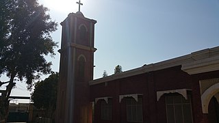
Jagdeo, Pakistan

Last updated
Jagday
Jagday
Pakistan location map.svg
Red pog.svg
Jagday
Coordinates: 31°04′N72°30′E / 31.07°N 72.50°E / 31.07; 72.50
Country Flag of Pakistan.svg  Pakistan
Province Punjab
Elevation
168 m (551 ft)
Time zone UTC+5 (PST)
Calling code 0413

Jagdeo, or Jagday, is a village in Samundri Tehsil in Faisalabad District in the Punjab province of Pakistan.Ch. imtiaz Ahmad Kamboh Advocate supreme court of Pakistan the grand son of The great ch Ghullam Nabi lumberdar of the village is the most loving personality of Jugday. It has an altitude of 168 metres (551 ft). It is the most influential village of the union council, no.120 of Tehsil Sammundri. It has a population of over eight thousand.

Samundri is an administrative subdivision, or tehsil, of Faisalabad District in the Punjab province of Pakistan. Samundri Tehsil farms are irrigated by Gugera Branch Canal and Burala Branch Canal.

Faisalabad District District in Punjab, Pakistan

Faisalabad District is one of the districts of Punjab province, Pakistan. According to the 1998 census of Pakistan it had a population of 3,029,547 of which almost 42% were in Faisalabad City. It is the third largest city of Pakistan after Karachi and Lahore.

Pakistan federal parliamentary constitutional republic in South Asia

Pakistan, officially the Islamic Republic of Pakistan, is a country in South Asia. It is the world’s sixth-most populous country with a population exceeding 212.7 million people. In area, it is the 33rd-largest country, spanning 881,913 square kilometres. Pakistan has a 1,046-kilometre (650-mile) coastline along the Arabian Sea and Gulf of Oman in the south and is bordered by India to the east, Afghanistan to the west, Iran to the southwest, and China in the northeast. It is separated narrowly from Tajikistan by Afghanistan's Wakhan Corridor in the northwest, and also shares a maritime border with Oman.

Contents

Name

The village was originally named Jagdeo in British Raj, after a Sikh called Jagdeo Singh. Over time, the name was modified to Jagday. According to the system of numbering the villages of Punjab on the basis of the Canal System of Punjab, Jagday was numbered as 41 G.B. as it lies along Gogera Branch Canal.

British Raj British rule on the Indian subcontinent, 1858–1947

The British Raj was the rule by the British Crown on the Indian subcontinent from 1858 to 1947. The rule is also called Crown rule in India, or direct rule in India. The region under British control was commonly called India in contemporaneous usage, and included areas directly administered by the United Kingdom, which were collectively called British India, and those ruled by indigenous rulers, but under British tutelage or paramountcy, and called the princely states. The whole was also more formally called the Indian Empire. As India, it was a founding member of the League of Nations, a participating nation in the Summer Olympics in 1900, 1920, 1928, 1932, and 1936, and a founding member of the United Nations in San Francisco in 1945.

Punjab, Pakistan Province in Pakistan

Punjab is Pakistan's most populous province, with an estimated population of 110,012,442 as of 2017. Forming the bulk of the transnational Punjab region, it is bordered by the Pakistani provinces of Sindh, Balochistan, and Khyber Pakhtunkhwa, the enclave of Islamabad, and Azad Kashmir. It also shares borders with the Indian states of Punjab, Rajasthan and Jammu and Kashmir. The capital is Lahore, a cultural, historical, economic and cosmopolitan centre of Pakistan where the country's cinema industry, and much of its fashion industry, are based.

People

Agriculture is the main economic force and source of income for the people of Jagday, but with passing time more and more people are opting for other professional fields and businesses. The basic cause of not sending the children to schools is poverty and ignorance of the value of educating their children, but the trend is changing. Most people of Jagday belong to the Kamboh caste, with a few other castes, such as Arain, Rehmani, Rajput, gujjar, malik, ansari, mochi, lohar, and Qureshi, present in small numbers. The Arain are the most educated and, there are only two three persons.

Agriculture Cultivation of plants and animals to provide useful products

Agriculture is the science and art of cultivating plants and livestock. Agriculture was the key development in the rise of sedentary human civilization, whereby farming of domesticated species created food surpluses that enabled people to live in cities. The history of agriculture began thousands of years ago. After gathering wild grains beginning at least 105,000 years ago, nascent farmers began to plant them around 11,500 years ago. Pigs, sheep and cattle were domesticated over 10,000 years ago. Plants were independently cultivated in at least 11 regions of the world. Industrial agriculture based on large-scale monoculture in the twentieth century came to dominate agricultural output, though about 2 billion people still depended on subsistence agriculture into the twenty-first.

Arain Pakistani tribe

Arain are a major landowning tribe found mainly in the provinces of Punjab and Sindh. In 1908 Punjabi Arains held over thirty-three percent of Jalandhar District's Land. The Arain caste holds one of the most prominent positions in Pakistan's politics, from 1985 to 2013, Arain's along with Rajputs, Sayyids and Jatts held the highest percentage of seats at the National Assembly.

Rajput member of one of the patrilineal clans of western, central, northern India and some parts of Pakistan and Nepal

Rajput is a large multi-component cluster of castes, kin bodies, and local groups, sharing social status and ideology of genealogical descent originating from the Indian subcontinent. The term Rajput covers various patrilineal clans historically associated with warriorhood: several clans claim Rajput status, although not all claims are universally accepted.

Education

The education rate in Jagday is poor, mainly due to poverty, child labor, and a lack of quality institutions. It has a boys' primary school and a girls' primary model school, which fail to fulfill the educational needs of the people. Therefore, most of the student go to the nearby government schools. Boys' and girls' high schools in 45 GB. [ clarification needed ] Some local private schools are competing with the government schools, but they too lack quality teachers. Anyone who wants to study further after the SSC. examination has to take admissions in the colleges of Gojra, Samundri, or Faisalabad. Very few actually get the chance to go to superior universities and get higher education. The Arain are far ahead in this regard, as most of their caste members are highly educated only two families of the caste ibdi are in the village. The youngest ever advocate supreme court of Pakistan in the whole of Pakistan, Ch.Imtiaz Ahmad Kamboh ASC belongs to this village.

Gojra Place in Punjab, Pakistan

Gojra, the administrative capital of Gojra Tehsil, is the city of Toba Tek Singh District in the Punjab in the province of Pakistan. Gojra is 30 miles (50 km) from Faisalabad, 170 km from Lahore, and 20 miles (32 km) north of Toba Tek Singh. Founded in 1896 during the British colonial period, Gojra was the commercial centre of lands which had recently come under cultivation, and was known for its "mandi" (market) for cash crops.

Markets and shops

Jagday has the biggest vegetable Market among nearby villages, where vegetables arrive fresh from the fields. A vegetable auction is held each afternoon, and then vegetables are transported to Faisalabad for sale in wholesale vegetable markets. Ghaffar Sweet Shop and Poond Shop along with Asgher & Janu Sweet Shop provide people with local sweets. Kariana Stores (the local name for general stores) are prevalent throughout the village to provide the basic necessities of life to the people. The Ghaffar/Poond store, Rehman Karian and journlestore, Rasalat jurra chorri house, Asma beauty parlour, Mooda store and Mehr Mukhtar store are a few of them. A few meat shops are also present. It is also an industrial village. There are so many power looms weaving factory and electric khadian[ check spelling ] in the village and the products such as khais, darian, and grey cloth is famous of jagday.


Related Research Articles

Toba Tek Singh District District in Punjab, Pakistan

Toba Tek Singh District is a district in the Punjab province of Pakistan. It is located between 30°33' to 31°2' Degree north latitudes and 72°08' to 72°48' Degree longitudes. It became a separate district in 1982.

Nowshera Virkan is a town and a tehsil situated to the west of the industrial city of Gujranwala, Punjab, Pakistan. Nowshera Virkan is a hub of rice-growing villages.

Arif Wala Tehsil City in Punjab, Pakistan

Arifwala, is a Tehsil of Pakpattan District in the Punjab province of Pakistan. It is located to the southwest of Pakpattan.

Tandlianwala City in Punjab, Pakistan

Tandlianwala is a town in Punjab, Pakistan and the headquarters of Tandlianwala Tehsil. It is located 55 km from the city of Faisalabad and 65 km from Okara. It is a sub-division of Faisalabad District and has a Tehsil municipal administration (TMA).

Gobind Pura is one of the oldest residential areas in Faisalabad, Punjab, Pakistan. It is centrally located near the city's "Ghanta Ghar". Located on the main Narwala Road, Gobind Pura is located opposite the Agriculture University of Faisalabad and adjacent to Jinnah Colony.

Sargodha Tehsil, is an administrative subdivision of the Sargodha District in the Punjab province of Pakistan. The tehsil is subdivided into 62 Union Councils - 22 of which form the city of Sargodha.

Pial Kalan Town in Punjab, Pakistan

Pial Kalan is a town and Union Council of Kasur District in the Punjab province of Pakistan. It is part of Kasur Tehsil and is located at 30°55'0N 74°13'60E with an altitude of 181 metres (597 feet).

Peerwana Village in Punjab, Pakistan

Peerwana is a village in Faisalabad District near Chak Jhumra, Punjab, Pakistan. It is in Chak Jhumra Town's Union Council#2. It is situated on the Faisalabad to Pindi Bhattian Motorway M3 near Sahianwala Interchange. It is one of the newly built motorways of Pakistan which connects Islamabad and Lahore to Faisalabad. Many people nearby villages have used it as a starting point for Lahore, Islamabad, Peshawar and Multan. It is 140 kilometers away from Lahore and 30 kilometers away from Faisalabad.

Rissiana is a village situated near Samundri, Faisalabad, Pakistan. There are actually two villages named Rissiana in this area; Rissiana Kalan and Rissiana Khurd. Both have the same village number and are located two kilometers apart. Rissiana used to be called Case Garh, and this name is still used in many official documents. The below details represents the demographics of Rissiana Khurd. Before the partition of sub continent in 1947, The village of Rissiana existed with Sikh majority. Rana Atta Muhammad is considered to be the pioneer immigrant who arrived here with his family from Sosana village of district Hushiarpur Indian Punjab. Sosana was a very small village but it has generated very prominent figures who contributed a lot for the development of Pakistan like Dr. Muhammad Saleem Khan and his son Rana Ayyaz Saleem, Dr. Iqrar Ahmad Khan (SI), Vice Chancellor of University of Agriculture (Faisalabad) and Waseem Afzal officer.

Mouza Talib Village in Punjab, Pakistan

Mouza Talib is a village in District Chiniot on Chak Jhumra road, Punjab, Pakistan. It is in Tehsil Chiniot's Union Council # 13 and is 8-km away from the Faisalabad to Pindi Bhattian Motorway M3 Sahianwala Interchange. Its Latitude is 31° 41' 28.08"N, and Longitude is 73° 0' 59.49"E. The people of Talib use M3 to commute as it is 140 kilometers away from Lahore and 30 kilometers away from Faisalabad. Nearby towns are Chak Jhumra, Chiniot, Sargodha, Lalian, Bhawana, Rabwah, Faisalabad and Pindi Bhattian. By road, Talib is connected to Barnala, Chak Jhumra, and Chiniot. The most famous things in Talib are Darbar Baba gard Ali, Canal Bridge, Government Primary school for Boys Girls and Government Middle school for girls.

Tandlianwala Tehsil City in Punjab, Pakistan

Tandlianwala is a town in Punjab, Pakistan, the headquarters of Tandlianwala Tehsil. It is located 35 km from the city of Faisalabad and 44 km from Okara. It is a sub-division of Faisalabad District and has a Tehsil municipal administration (TMA).

Kohali, Faisalabad Village in Punjab, Pakistan

Kohali is a village of union council 47-GB of samundri of Faisalabad District in the Punjab province of Pakistan. It is part of samundri, and located at latitude 31° 7'45.50"N and longitude 72°47'56.72"E with an altitude of 563 feet. It was very rich and historical village before independence. There are four mosques and one Imambargah in the village. More influential tribes and clans are Rajput, Jat, Arian, etc. Main occupation of the people are cultivation. This village is located about 10 km (6.2 mi) from Gojra and about 29 km (18 mi) from Samundri.

Satiana Village in Punjab, Pakistan

Satiana Bunglaw is a little City in Tehsil Jaranwala District Faisalabad, Punjab, Pakistan. It is 27 km from Faisalabad, 25 km from Jaranwala and 23 km from Tandlianwala It is situated on the Tandlianwala-Faisalabad road. Cities linked via road with Satiana are:

  1. Faisalabad
  2. Tandlianwala
  3. Okara
  4. Jaranwala
  5. Samundri

Chak NO 217 GB, Gujjar Pind Tehsil Samundri is a suburb of Samundri Tehsil, in the Faisalabad District, Pakistan. The population consists entirely of Gujjar tribe people, most of whom migrated from the Indian Punjab's city Hoshyarpur from 1947 to 1948.

Todarpur Urf Theh Pachrali is a village in the Garhshanker tehsil within the Hoshiarpur district of Punjab state, India-144404.

Kangna (village) Village in Punjab, India

Kangna is a village in Nakodar in Jalandhar district of Punjab State, India. It is located 11.7 km from Nakodar, 33.5 km from Kapurthala, 35.3 km from district headquarter Jalandhar and 167 km from state capital Chandigarh. The village is administrated by a sarpanch who is an elected representative of village as per Panchayati raj (India).

Chak No.285-GB, District Toba Tek Singh Village in Punjab, Pakistan

Chak # 285 GB is a large size village of tehsil & District Toba Tek Singh, Punjab, Pakistan. It is a part of Union Council Number 42, along with closest villages, Chak No. 286 GB, Chak No. 284 GB. Chak No. 291 GB. A Karachi - Lahore Motorway is underway through this village & a Interchange is going to build beside the Rajana. These all villages are on Gugera Branch Canal. The postal code is 36071. Punjabi is the native spoken language but as a national language Urdu is also widely used. Major castes of this village are (pathan) Syed, Gujjar, Arain, Rajputs, Khokhar, etc.

References

    Coordinates: 31°7′0″N72°50′0″E / 31.11667°N 72.83333°E / 31.11667; 72.83333

    Geographic coordinate system Coordinate system

    A geographic coordinate system is a coordinate system that enables every location on Earth to be specified by a set of numbers, letters or symbols. The coordinates are often chosen such that one of the numbers represents a vertical position and two or three of the numbers represent a horizontal position; alternatively, a geographic position may be expressed in a combined three-dimensional Cartesian vector. A common choice of coordinates is latitude, longitude and elevation. To specify a location on a plane requires a map projection.