
Amethi is a city situated in the Indian state of Uttar Pradesh. Gauriganj is the administrative headquarters of the Amethi district. This district is a part of Ayodhya division in the Awadh region of the state. Amethi was 72nd district of Uttar Pradesh which came into existence on 1 July 2010 by merging three tehsils of the erstwhile Sultanpur district namely Amethi, Gauriganj and Musafirkhana and two tehsils of the erstwhile Raebareli district, namely, Salon and Tiloi. The town is part of the Amethi Lok Sabha constituency and Amethi Assembly constituency, which became reputed as a stronghold of the Indian National Congress party. The Congress leaders belonging to Nehru-Gandhi family won several elections from Amethi during 1980–2014. In 2019, Smriti Irani of Bhartiya Janta Party won this seat.

Sultanpur is a city situated in the Indian state of Uttar Pradesh on the banks of the Gomti, which Hindus consider a holy river. The city is the administrative headquarters of Sultanpur district and is a part of Ayodhya division in Uttar Pradesh, India. It is situated 135 kilometers east of state capital Lucknow.
Sultanpur district is a district in the Awadh region of the Indian state of Uttar Pradesh. This district is a part of Ayodhya division of the state. The administrative headquarters of the district is Sultanpur city. The total area of Sultanpur district is 2672.89 Sq. km.
Hamirpur is a town and a municipal board in Hamirpur district in the Indian state of Uttar Pradesh. Located just above the confluence of the Yamuna and Betwa rivers, it is the administrative headquarters of Hamirpur district.
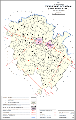
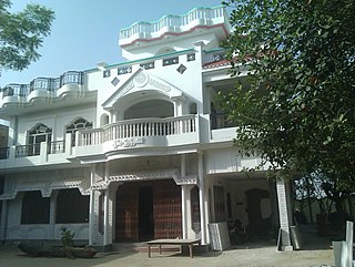
Gosainganj, also spelled Goshainganj or Gosaiganj is a town and nagar panchayat in Lucknow district of Uttar Pradesh, India. It is the seat of a community development block, which is included in the tehsil of Mohanlalganj. As of 2011, its population is 9,649, in 1,685 households. The starting point of the Purvanchal Expressway i.e. Chand Saray village is situated 2.5 km away from Gosainganj.

Jais, also spelled Jayas, is a city with a municipal board in Amethi district in the Indian state of Uttar Pradesh.
Kerakat or Kirakat is a town and nagar panchayat in Jaunpur district of the Indian state of Uttar Pradesh with a population of approximately 13,500. It is situated near the Gomati River, which helps the land around the town stay very fertile. Kerakat or Kirakat forms a part of Varanasi Division. It is located 30 km east of the city of Jaunpur and 279 km from Lucknow, the capital of Uttar Pradesh.

Musafirkhana is a town and tehsil in Amethi district in Indian state of Uttar Pradesh. The word "Musafirkhana" means "Sarai," or "Dharamshala". Musafirkhana is located 32 km northwest of district headquarters Amethi.
Tanda is a town in Ambedkar Nagar district in the Indian state of Uttar Pradesh situated on the banks of Ghaghara River. It is a nagar palika parishad and is part of Ayodhya division in Uttar Pradesh. The town is situated 20 kilometres (12 mi) north east from district headquarter Akbarpur. Tanda is also a tehsil in the district. It has one of the largest handloom weaving industries for manufacturing varieties like gamchha, lungi, polyester clothing, check-shirt clothes material in state of Uttar Pradesh.

Gauriganj is a city, municipal corporation, tehsil and administrative headquarters of Amethi district in Ayodhya division, Uttar Pradesh, India. It is situated about 126 km from the state capital Lucknow. Before July 2010, it was part of Sultanpur district. After that Gauriganj, Amethi, Jais, Jagdispur and Salon formed a new district Chhatrapati Sahuji Maharaj Nagar, later named Gauriganj and now Amethi. Gauriganj is connected with State Highway 34 and National Highway 128.
Amethi is one of the 75 districts of the northern Indian state of Uttar Pradesh. This district is a part of Ayodhya division in the Awadh region of Uttar Pradesh. It covers an area of 2,329.11 km2. Gauriganj is the administrative headquarters of the district.
Usraon (Mariyahu) is a town and nagar panchayat in Jaunpur district in the Indian state of Uttar Pradesh. It is one of the six tahsils of Jaunpur District; the others are Jaunpur City, Shahganj, Machalishahar, Badlapur and Kerakat.
Lambhua is a town, tehsil, and a Nagar panchayat in Sultanpur district in the Indian state of Uttar Pradesh. It is located on the National Highway 731.
Badlapur is an administrative division in Jaunpur District in the Indian state of Uttar Pradesh. It was accorded the status of Town Area Nagar Panchayat on 27 June 2014.
Rajesultanpur or Raje Sultanpur is a town and nagar panchayat in Ambedkar Nagar district in the Indian state of Uttar Pradesh.
Bhimapar is a village and a Gram panchayat in Ghazipur district of Uttar Pradesh, India. Bhimapar is a developing and new face town. It is 57 km from Varanasi and 57 km from Ghazipur.
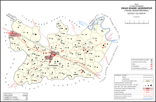
Jagdishpur is a town, community development block, and former pargana in Musafirkhana tehsil of Amethi district, Uttar Pradesh, India. It is also called Nihalgarh, Chak Jangla, or Nihalgarh-Jagdispur. The distinction is that Jagdishpur was the original village, Chak Jangla was an outlying hamlet of Jagdishpur, and Nihalgarh was a fort built in Chak Jangla in the early 1700s and that no longer exists. The town is located at the crossroads between the Lucknow-Jaunpur and Raebareli-Faizabad highways.
Gaimau is a village in Jagdishpur block of Sultanpur district, Uttar Pradesh, India. It is located 50 km from Sultanpur, the district headquarters. As of 2011, it has a population of 1,617 people, in 255 households. It has one primary school and no healthcare facilities and does not host a permanent market or weekly haat. It belongs to the nyaya panchayat of Harimau.
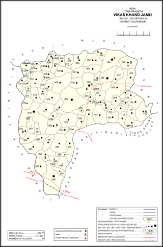
Gaura is a village in Jamo block of Amethi district, Uttar Pradesh, India. The namesake of the historical pargana of Gaura Jamun, Gaura consists of a main site called Gaura khas in the northeast surrounded by several smaller hamlets. The village lands are fertile and contain many orchard groves. In the east-central part there is a large jhil which provides a convenient source of irrigation but also sometimes overflows and floods the surrounding fields. Gaura is located just north of Jamo on the Gauriganj-Jagdishpur road, and another road also leads off to Musafirkhana.
Katari is a village in Jamo block of Amethi district, Uttar Pradesh, India. It is located by a stream called the Naiya or Kandu nala, which flows east toward the Gomti river. The main highway from Lucknow to Jaunpur passes further north. Katari was historically the seat of a taluqdari estate held by a leading branch of the Kanhpuria Rajputs.

