James Alexander Robertson Menzies

Last updated

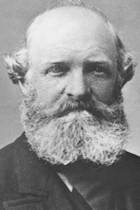
James Alexander Robertson Menzies (21 February 1821 – 18 August 1888) was the first Superintendent of the Southland Province in New Zealand from 3 August 1861 to November 1864 during its breakaway from Otago Province (1861 to 1870). [1] He continued serving on the Provincial Council after his superintendency ended. [2]

Superintendent was the elected head of each Provincial Council in New Zealand from 1853 to 1876.

Southland Province

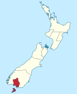
The Southland Province was a province of New Zealand from March 1861, when it split from Otago Province, until 1870, when it rejoined Otago.

New Zealand Country in Oceania

New Zealand is a sovereign island country in the southwestern Pacific Ocean. The country geographically comprises two main landmasses—the North Island, and the South Island —and around 600 smaller islands. New Zealand is situated some 2,000 kilometres (1,200 mi) east of Australia across the Tasman Sea and roughly 1,000 kilometres (600 mi) south of the Pacific island areas of New Caledonia, Fiji, and Tonga. Because of its remoteness, it was one of the last lands to be settled by humans. During its long period of isolation, New Zealand developed a distinct biodiversity of animal, fungal, and plant life. The country's varied topography and its sharp mountain peaks, such as the Southern Alps, owe much to the tectonic uplift of land and volcanic eruptions. New Zealand's capital city is Wellington, while its most populous city is Auckland.

During his tenure as Superintendent, two railways projects were undertaken, a railway to link Invercargill to the port at Bluff and a wooden railway to Winton. The former is now known as the Bluff Branch, while the latter was upgraded to the standards of a normal railway and extended to ultimately form the Kingston Branch. [1]

Invercargill Place in South Island, New Zealand

Invercargill is the southernmost and westernmost city in New Zealand, and one of the southernmost cities in the world. It is the commercial centre of the Southland region. The city lies in the heart of the wide expanse of the Southland Plains on the Oreti or New River some 18 km north of Bluff, which is the southernmost town in the South Island. It sits amid rich farmland that is bordered by large areas of conservation land and marine reserves, including Fiordland National Park covering the south-west corner of the South Island and the Catlins coastal region.

Bluff, New Zealand human settlement

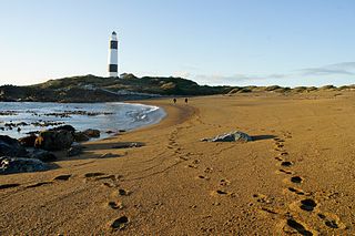
Bluff, previously known as Campbelltown and often referred to as "The Bluff", is a town and seaport in the Southland region, on the southern coast of the South Island of New Zealand. It is the southernmost town in mainland New Zealand and, despite Slope Point and Stewart Island being further south, Bluff is colloquially used to refer to the southern extremity of the country. According to the 2006 census, the resident population was 1,850, a decrease of 85 since 2001.

Wagonway

Wagonways consisted of the horses, equipment and tracks used for hauling wagons, which preceded steam-powered railways. The terms plateway, tramway and dramway were used. The advantage of wagonways was that far bigger loads could be transported with the same power.

He served on the Legislative Council for 30 years, from 1858 until his death in 1888, and promoted the interests of Southland. [1]

New Zealand Legislative Council Upper House of the Parliament of New Zealand (1841 - 1951)

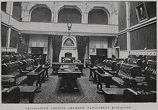
The Legislative Council of New Zealand existed from 1841 until 1951. When New Zealand became a colony in 1841 the Legislative Council was established as the country's first legislature; it was reconstituted as the upper house of a bicameral legislature when New Zealand became self-governing in 1852.

See also

Related Research Articles

South Island Southernmost of the two main islands in New Zealand

The South Island, also officially named Te Waipounamu, is the larger of the two major islands of New Zealand in surface area; the other being the smaller but more populous North Island. It is bordered to the north by Cook Strait, to the west by the Tasman Sea, and to the south and east by the Pacific Ocean. The South Island covers 150,437 square kilometres (58,084 sq mi), making it the world's 12th-largest island. It has a temperate climate.

Gore, New Zealand Town and district in Southland, New Zealand

Gore is a town and district in the Southland region of the South Island of New Zealand.

Provinces of New Zealand administrative areas of New Zealand between 1841-1876

The provinces of the Colony of New Zealand existed as a form of sub-national government. Established in 1841, each province had its own legislature and was built around the six original planned settlements or "colonies". By 1873 the number of provinces had increased to nine, but they had become less isolated from each other and demands for centralised government arose. In 1875 the national parliament decided to abolish the provincial governments, and they came to an end in 1876. They were superseded by counties, which were later replaced by territorial authorities.

Riverton, New Zealand Place in South Island, New Zealand

Riverton or Aparima is a small town 30 kilometres west of Invercargill via State Highway 99 on the Southern Scenic Route. It is situated on the south-eastern shorelines of the Jacobs River Estuary being formed by the Aparima and Pourakino Rivers, which leads through a narrow outflow channel into Foveaux Strait. The main part of the town is on flat land and the northern end of Oreti Beach but South Riverton is built on the hills between the eastern shore of the estuary and Taramea Bay.

The Tokanui Branch, also known as the Seaward Bush Branch, was a branch line railway located in Southland, New Zealand. It diverged from the Bluff Branch south of the main railway station in Invercargill and ran for 54 kilometres in a southeasterly direction. Construction began in 1883 and it operated until 1966.

The Bluff Branch, officially the Bluff Line since 2011, is a railway line in Southland, New Zealand that links Invercargill with the port of Bluff. One of the first railways in New Zealand, it opened in 1867 and is still operating. Presently, it essentially functions as an elongated industrial siding.

Otago Province former province of New Zealand

The Otago Province was a province of New Zealand until the abolition of provincial government in 1876. The capital of the province was Dunedin. Southland Province split from Otago in 1861, but became part of the province again in 1870.

William Wood (New Zealand politician) 19th-century New Zealand politician

William Wood was a 19th-century New Zealand politician.

The following lists events that happened during 1821 in New Zealand.

John Parkin Taylor New Zealand politician

John Parkin Taylor was a 19th-century New Zealand runholder, and a politician in Otago and Southland. In his early life, Taylor lived in various countries and studied languages in Germany. He worked as a merchant and got married when he returned to England. Taylor's family emigrated to New Zealand in 1849 and he was a sheep farmer in various parts of the South Island before finally settling on a run near Riverton in Southland, where he had his homestead 'Waldeck' built. He entered the House of Representatives for the Dunedin Country electorate through a by-election in 1858 but fell out with many of his constituents over a broken election promise, as he helped the Southland Province to break away from the Otago Province. He eventually became Southland's second Superintendent and served from 1865 to 1869, and also represented an electorate on the Southland Provincial Council for a few months. In 1865, he was appointed to the New Zealand Legislative Council and with one break in membership due to non-attendance, he remained a member until his death. He served for one year as mayor of Riverton (1872–73) but did not stand again due to poor health. Taylor had a painful illness and died in 1875.

Gore District, New Zealand Territorial authority in Southland, New Zealand

Gore District is a municipality in the Southland region of the South Island of New Zealand.

John Perry Robinson New Zealand politician

John Perry Robinson was the second Superintendent of the Nelson Province in New Zealand. His election came as a surprise, but he proved so popular that he won two subsequent elections with comfortable majorities. He remained Superintendent until his accidental drowning on the bar of the Buller River.

Southland, New Zealand Region of New Zealand in South Island

Southland is New Zealand's southernmost region. It consists mainly of the southwestern portion of the South Island and Stewart Island / Rakiura. It includes Southland District, Gore District and the city of Invercargill. The region covers over 3.1 million hectares and spans over 3,400 km of coast.

Alfred Baldey was a member of the New Zealand Legislative Council representing Liberal Party interests from Southland.

1858 Dunedin Country by-election New Zealand by-election

The Dunedin Country by-election 1858 was a by-election held in the multi-member Dunedin Country electorate during the 2nd New Zealand Parliament, on 16 June 1858. The by-election was caused by the resignation of incumbent MP John Cargill and was won by John Taylor.

Dog Island (New Zealand) island in New Zealand

Dog Island is located in Foveaux Strait some 5 kilometres (3.1 mi) from Bluff, New Zealand. It holds New Zealand's tallest lighthouse and since the maritime structure was fully automated in 1989, the island has been uninhabited.

Neil Lachlan Watson was a New Zealand politician who served as Mayor of Invercargill from 1962 to 1971.

References

  1. 1 2 3 Hall-Jones, John. "Menzies, James Alexander Robertson". Dictionary of New Zealand Biography . Ministry for Culture and Heritage . Retrieved 23 May 2010.
  2. "Portrait of Dr J. A. R. Menzies". Southland District Council. Retrieved 23 May 2010.
Political offices
First Superintendent of Southland Province
18611864
Succeeded by
John Parkin Taylor