
Lincolnshire is a ceremonial county in the East Midlands and Yorkshire and the Humber regions of England. It is bordered by the East Riding of Yorkshire across the Humber estuary to the north, the North Sea to the east, Norfolk, Cambridgeshire, Northamptonshire and Rutland to the south-west, the south and the south-east, and Leicestershire, Nottinghamshire and South Yorkshire to the west. The county town is Lincoln.

The River Witham is a river almost entirely in the county of Lincolnshire in the east of England. It rises south of Grantham close to South Witham at SK8818, passes through the centre of Grantham, passes Lincoln at SK9771 and at Boston, TF3244, flows into The Haven, a tidal arm of The Wash, near RSPB Frampton Marsh. The name "Witham" seems to be extremely old and of unknown origin. Archaeological and documentary evidence shows the importance of the Witham as a navigable river from the Iron Age onwards. From Roman times it was navigable to Lincoln, from where the Fossdyke was constructed to link it to the River Trent. The mouth of the river moved in 1014 following severe flooding, and Boston became important as a port.
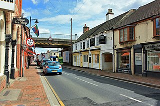
Market Rasen is a market town and civil parish within the West Lindsey district of Lincolnshire, England. The River Rase runs through it east to west, approximately 13 miles (21 km) north-east from Lincoln, 18 miles (29 km) east from Gainsborough, 14 miles (23 km) west of Louth, and 16 miles (26 km) south-west from Grimsby. It lies on the main road between Lincoln and Grimsby, the A46, and is famous for its racecourse. In 2001, the town had a population of 3,200. In the 2011 census, the population of the civil parish was 3,904.

The Parts of Lindsey are a traditional division of Lincolnshire, England, covering the northern part of the county. The Isle of Axholme, which is on the west side of the River Trent, has normally formed part of it. The district's name originated from the Kingdom of Lindsey of Anglo-Saxon times, whose territories were merged with that of Stamford to form Lincolnshire.
Lincolnshire, England derived from the merging of the territory of the ancient Kingdom of Lindsey with that controlled by the Danelaw borough Stamford. For some time the entire county was called 'Lindsey', and it is recorded as such in the Domesday Book. Later, Lindsey was applied to only the northern core, around Lincoln; it was defined as one of the three 'Parts of Lincolnshire', along with Holland in the south-east and Kesteven in the south west.

Bardney is a village and civil parish in the West Lindsey district of Lincolnshire, England. The population of the civil parish was 1,643 at the 2001 census increasing to 1,848 at the 2011 census. The village sits on the east bank of the River Witham and 9 miles (14 km) east of Lincoln.
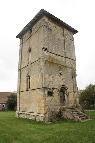
Temple Bruer Preceptory is a historic building in the civil parish of Temple Bruer with Temple High Grange, North Kesteven, Lincolnshire, England. It is one of the few Knights Templar sites left in England where any ruins remain standing. Its name comes from its Templar ownership and its position in the middle of the Lincoln Heath, bruyère (heather) from the French language current at the time. It was founded in the period 1150 to 1160 and the order was dissolved in 1312. The site is located between the A15 and A607 roads, 2.5 miles (4.0 km) north from Cranwell. The site has been excavated twice, firstly by the Rev Dr. G. Oliver, the rector of Scopwick in 1832–3, and in 1908 by Sir William St John Hope.

The Louth Navigation was a canalisation of the River Lud. It ran for 11 miles (18 km) from Louth in Lincolnshire, England, to Tetney Haven, at the mouth of the Humber. It was authorised by Act of Parliament in 1763 and completed in 1770, under the supervision of the engineer John Grundy Jr. and then by James Hoggard. Eight locks were required to overcome the difference in altitude, six of which were constructed with sides consisting of four bays.
The ceremonial county of Lincolnshire is the second largest of the English counties and one that is predominantly agricultural in character. Despite its relatively large physical area, it has a comparatively small population. The unusually low population density that arises gives the county a very different character from the much more densely populated and urbanised counties of south-east and northern England, and is, in many ways, key to understanding the nature of the county.

The South Forty-Foot Drain, also known as the Black Sluice Navigation, is the main channel for the land-drainage of the Black Sluice Level in the Lincolnshire Fens. It lies in eastern England between Guthram Gowt and the Black Sluice pumping station on The Haven, at Boston. The Drain has its origins in the 1630s, when the first scheme to make the Fen land available for agriculture was carried out by the Earl of Lindsey, and has been steadily improved since then. Water drained from the land entered The Haven by gravity at certain states of the tide until 1946, when the Black Sluice pumping station was commissioned.
Lincolnshire is a large county in England with a sparse population distribution, which leads to problems funding all sorts of transport. The transport history is long and varied, with much of the road network still based on the Roman model, and the once extensive rail network a shadow of its former self.
Brothertoft is a village in the civil parish of Holland Fen with Brothertoft, in the Boston district, in the county of Lincolnshire, England. It is about 4 miles (6.4 km) northwest from the market town of Boston.
The Great Grimsby and Sheffield Junction Railway was an early British railway company which existed between 1845 and 1847 with the intention of providing rail services between Grimsby, New Holland and Gainsborough in the county of Lincolnshire. It amalgamated with the Sheffield, Ashton-Under-Lyne and Manchester Railway and the Sheffield and Lincolnshire Junction Railway, the three being renamed the Manchester, Sheffield and Lincolnshire Railway in 1847.
Great Limber Preceptory, Limber Magna was a Camera (farm) of the Knights Templar and later the Knights Hospitaller in the village of Great Limber, Lincolnshire, England.
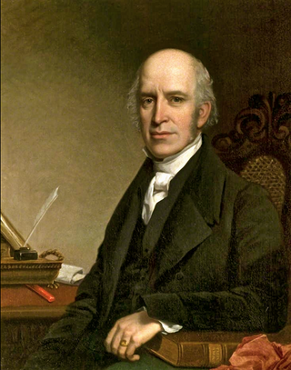
Edward James Willson was an English architect, antiquary, architectural writer, and mayor of Lincoln in 1851–2.

Great Limber is a village and civil parish in the West Lindsey district of Lincolnshire, England. The population of the civil parish at the 2011 census was 271. It is on the A18, 8 miles (13 km) west from Grimsby and 8 miles east from Brigg.

Withham Preceptory, one of the smallest Knights Templar preceptories in England, was founded, before 1164, at Temple Hill, near South Witham, Lincolnshire, and was abandoned in the early 14th century. The site of the former preceptory at Temple Hill, South Witham. It 'has been largely under pasture' since the Knights Templar left in 1308.

Thropp and Harding were surveyors and an architectural practice in Lincoln working from 1 James Street and 29 Broadgate, Lincoln. James Thropp was initially in partnership with James Sandby Padley until 1881 He then worked on his own until 1901. Between 1891 and 1896, the Lincoln architect Herbert Henry Dunn was his assistant and at the same time, 1891–6, George Robinson Harding, was articled to him. In 1901 Thropp and Harding formed a partnership which was dissolved in Oct 1921. The architectural practice continued under Harding until after the Second World War. Thropp was a member of the Institute of Civil Engineers and was surveyor to the Lindsey County Council. In 1883 Thropp published a 3rd edition of Padley's large scale survey of Lincoln. James Thropp of 27 Bailgate died 8 September 1923

