This article needs additional citations for verification .(January 2017) |
Jano | |
|---|---|
Municipality | |
 Jano | |
| Coordinates: 15°03′N86°30′W / 15.050°N 86.500°W | |
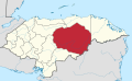
| Country | |
| Department | |
| Villages | 8 |
| Area | |
• Total | 362.71 km2 (140.04 sq mi) |
| Population (2015) | |
• Total | 4,805 |
| • Density | 13/km2 (34/sq mi) |
Jano is a town and municipality in the north west of the Honduran department of Olancho, west of Guata, south of Esquipulas del Norte and north of Manto, Honduras.