El Paraíso is one of the 18 departments (departamentos) into which Honduras is divided.

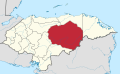
Olancho is the largest of all the 18 departments into which Honduras is divided. The department covers a total surface area of 24,057 km² and has an estimated 2015 population of 537,306 inhabitants.

La Ceiba is a municipality, the capital of the Honduran department of Atlántida and a port city on the northern coast of Honduras in Central America. It is located on the southern edge of the Caribbean, forming part of the south eastern boundary of the Gulf of Honduras. With an estimated population of 199,080 living in approximately 170 residential areas, it is the fourth most populous and third most important city in the country.
La Esperanza is the capital city and a municipality of the same name of the department of Intibucá, Honduras. La Esperanza is famous for having the coolest climate in Honduras. It is considered the heart of the Ruta Lenca, a region of Lenca ethnic influence that spans Honduras from Santa Rosa de Copan to Choluteca. Sites on the Lenca Trail have been designated by the government and United Nations development in order to encourage more cultural tourism, and help create new markets for the traditional crafts, such as pottery, practiced by the Lenca, in order to preserve their culture.

Duyure is a municipality located in the Honduran department of Choluteca.

Siguatepeque is a city and municipality in the Honduran department of Comayagua. The city has a population of 73,480.
Villanueva is a city, with a population of 77,250, and a municipality in the Honduran department of Cortés.

Ojojona is a municipality in the Honduran department of Francisco Morazán, located 34 km south of Tegucigalpa. The town is one of the many touristic places of near the capital of Honduras, Tegucigalpa. It is also the place of birth of notable natives include the painter Pablo Zelaya Sierra.

Talanga is a town, with a population of 19,860, and a municipality in the Honduran department of Francisco Morazán.
Olanchito is a municipality in the department of Yoro, Honduras, and a town with a population of 45,270 as of 2020. The municipality was founded in 1530 and comprises 70 villages, approximately 300 hamlets, and approximately 100,000 inhabitants. It is located 107 miles (172 km) northeast of Tegucigalpa, the country's capital. Olanchito operates in the Central Time Zone, with a UTC offset of -6 hours. The city is the birthplace of many popular figures of Honduran literature such as Ramón Amaya Amador, whose manuscripts, collection of books, writing table, and ashes are located in Olanchito. Known locally as the Civic City, Olanchito's main industry is agriculture.

Catacamas is a city, with a population of 59,990, and a municipality in the Olancho Department of Honduras.
Concordia is a municipality in the south west of the Honduran department of Olancho, north of Campamento, west of Juticalpa and south of Guayape and Salamá.

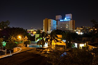
Juticalpa is the capital of Olancho Department in Honduras, with a population of 69,850, and the municipal seat of Juticalpa Municipality. Situated in a broad river valley alongside the Rio Juticalpa, the town is a commercial centre for much of Olancho's ranching and agricultural economy.

La Unión is a municipality in the northwest of the Olancho Department of Honduras.

Minnesota State Highway 371 (MN 371) is a 107.411-mile-long (172.861 km) highway in central and north-central Minnesota. The route connects Minnesota's northern lakes region with the central part of the state. It runs south–north from U.S. Highway 10 (US 10) in Little Falls to US 2 in Cass Lake. MN 371 has become a heavily traveled arterial route that was once a two-lane roadway over almost all of its length, but has been widened to four lanes across most of its southern half. Much of the traffic utilizing the route is Twin Cities-based traffic heading to their cabins on one of the many northern lakes.

Liga de Ascenso is the second division of Honduran football; it was founded on 17 December 1979 as Segunda División and renamed Liga de Ascenso on 21 July 2002. The league is divided into 4 groups: Zona Norte y Atlántica, Zona Norte y Occidente, Zona Centro y Sur, Zona Sur y Oriente. The top 2 teams of each group qualifies for the liguilla (play-offs). Each season is divided into two tournaments, apertura (opening) and clausura (closing). The champion of the opening and closing tournament, compete for the promotion to Liga Nacional de Fútbol de Honduras in a two-legged match.

El Esquilinchuche is a small village in the municipality of Juticalpa, Olancho, Honduras.

San Juancito is a small pueblo in central Honduras, located 40 km northeast of Tegucigalpa, the nation's capital. The town is in the department of Francisco Morazán. Including the dependent hamlets of Nuevo Rosario, Guacamaya, and Plan Grande, the population totals at about 1400. Its central neighborhood is depicted on the back of the 500-lempira bill.
Tegucigalpa, formally Tegucigalpa, Municipality of the Central District, and colloquially referred to as Tegus or Teguz, is the capital and largest city of Honduras along with its sister city, Comayagüela.
The network of highways in Honduras is managed by the Secretariat of public works, transport and housing (SOPTRAVI), through the General Directorate of Roads, which is responsible for planning construction and maintenance work on the country's roads. Honduras has more than 15,400 kilometres (9,600 mi) of roads. Up to 1999, only 3,126 kilometres (1,942 mi) had been paved.