
The River Don is a river in South Yorkshire and the East Riding of Yorkshire, England. It rises in the Pennines, west of Dunford Bridge, and flows for 69 miles (111 km) eastwards, through the Don Valley, via Penistone, Sheffield, Rotherham, Mexborough, Conisbrough, Doncaster and Stainforth. It originally joined the Trent, but was re-engineered by Cornelius Vermuyden as the Dutch River in the 1620s, and now joins the River Ouse at Goole. Don Valley is a UK parliamentary constituency near the Doncaster stretch of the river.

Jarrow is a town in South Tyneside in the county of Tyne and Wear, England. Historically in County Durham, it is on the south bank of the River Tyne, about three miles from the east coast. The 2011 census area classed Hebburn and The Boldons as part of the town, it had a population of 43,431. It is home to the southern portal of the Tyne Tunnel and five miles east of Newcastle upon Tyne.
South Tyneside is a metropolitan borough in the metropolitan county of Tyne and Wear, England. It is bordered by all four other boroughs in Tyne and Wear: Gateshead to the west, Sunderland in the south, North Tyneside to the north and Newcastle upon Tyne to the north-west. The border county of Northumberland lies further north. The borough was formed on 1 April 1974 by the merger of the County Borough of South Shields with the municipal borough of Jarrow and the urban districts of Boldon and Hebburn from County Durham.
Cockermouth is a market town and civil parish in the Cumberland unitary authority area of Cumbria, England, so named because it is at the confluence of the River Cocker as it flows into the River Derwent. The mid-2010 census estimates state that Cockermouth has a population of 8,204, increasing to 8,761 at the 2011 Census.

South Shields is a coastal town in South Tyneside, Tyne and Wear, England; it is on the south bank of the mouth of the River Tyne. The town was once known in Roman times as Arbeia and as Caer Urfa by the Early Middle Ages. In 2021 it had a population of 75,337. It is the fourth largest settlement in Tyne and Wear, after Newcastle upon Tyne, Sunderland and Gateshead.

North Shields is a town in the borough of North Tyneside in Tyne and Wear, England. It is 8 miles (13 km) north-east of Newcastle upon Tyne and borders nearby Wallsend and Tynemouth.

Jarrow Hall is a museum in Jarrow, South Tyneside, England which celebrates the life of the Venerable Bede; a monk, author and scholar who lived in at the Abbey Church of Saint Peter and Saint Paul, Wearmouth-Jarrow, a double monastery at Jarrow and Monkwearmouth,, England.

Newbridge is a town and community in the county borough of Caerphilly, south Wales. It lies within the historic boundaries of the county of Monmouthshire.

The Boldons is an area made up of the three villages of East Boldon, West Boldon and Boldon Colliery in South Tyneside in the county of Tyne and Wear, England. In 2001 they had a population of 13,271.

Hebburn is a town in the South Tyneside borough of Tyne and Wear, England. It was formerly in County Durham until 1974 with its own urban district from 1894 until 1974. It is on the south bank of the River Tyne between Gateshead and Jarrow and opposite Wallsend and Walker.

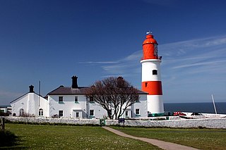
Cleadon is a suburban village in South Tyneside in the North East of England. Prior to the creation of Tyne and Wear in 1974 by the Local Government Act 1972, the village was part of the historic County Durham. In the 2011 UK Census the population of the South Tyneside ward of Cleadon and East Boldon was 8,427. Nearby population centres include East Boldon, Whitburn, and Jarrow. The village is located approximately 5 miles (8 km) from the city of Sunderland and 5 miles from the town South Shields. It is situated on the south west of Cleadon Hills, an example of a Magnesian Limestone grassland home to a number of regionally and nationally rare species.

Westoe was originally a village near South Shields, in the South Tyneside district, in Tyne and Wear, England, but has since become part of the town and is now used to refer to the area of the town where the village once was. It is also an electoral ward for local political purposes.
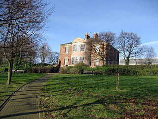
Jarrow Hall is a grade II listed building in Jarrow, Northeast England, and part of the larger Jarrow Hall museum site. It was built around 1785 by local businessman Simon Temple; he later went bankrupt in 1812 after a series of poor investments. The hall then passed through a number of hands before being let to the Shell Mex company in 1920, and then the Jarrow Council in 1935. The Council used the hall for a storage depot, eventually letting the building become derelict and in threat of demolition. It was rescued by the St Paul's Development Trust, which funded a £50,000 restoration project.

Scotswood Railway Bridge is a pipeline bridge and former railway bridge crossing the River Tyne in North East England. It previously carried the Newcastle and Carlisle Railway between Scotswood and Blaydon stations.

Peasholm Park is an oriental themed municipal park located in the seaside town of Scarborough, North Yorkshire, England. It opened in 1912 and became a venue for galas, displays and exhibitions. The park was extended to include Peasholm Glen, a natural ravine, in 1924. Attractions include an artificial boating lake, where mock naval battles are staged, a putting green and a champion tree walk. The park suffered a decline in use from the 1970s as the number of holidaymakers visiting Scarborough decreased but it has been restored using Heritage Lottery Funding.
The accident at St Bedes Junction was one of several serious accidents in 1915. It featured a double collision and fire fuelled by gas, characteristics shared by a much worse accident that year at Quintinshill. There were also similarities in that a signalman was unaware of the presence of a train near his signal box and rules were not observed. The accident is sometimes referred to as the Jarrow railway disaster as there was no station at Bede and Jarrow was then the nearest place of importance.

Clifford's Fort was a defensive gun battery established near the mouth of the Tyne during the Anglo-Dutch Wars in the 17th century. It subsequently served as a submarine mining depot and survives today as a Scheduled Ancient Monument in the historic Fish Quay area of North Shields, Tyne and Wear, in North East England.

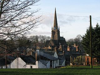
The Church of St Peter is a Church of England Grade II* listed church located on the east side of Wallsend, North Tyneside. It was constructed to replace Holy Cross Church, which had been built c. 1150 but had fallen into disrepair by the end of the 18th century. The building was extensively remodelled in 1892 in the Perpendicular style to give it its present form. The parish church is the oldest in Wallsend

South Tyneside Council is the local authority of for the metropolitan borough of South Tyneside in the ceremonial county of Tyne and Wear in North East England. It is one of five metropolitan boroughs in Tyne and Wear and one of 36 in England. It provides the majority of local government services in South Tyneside. The council has been under Labour majority control since 1979. It is based at South Shields Town Hall. The council is a constituent member of the North East Mayoral Combined Authority.

Jarrow Town Hall is a municipal building in Grange Road, Jarrow, Tyne and Wear, England. The town hall, which was the headquarters of Jarrow Borough Council, is a Grade II listed building.
