Krbavica is a village in Croatia, located in Lika near Korenica. The population is 62. Pribići is a section of Krbavica. The village is eponymous to the nearby Krbavsko Polje.
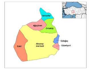
Ağaçören, formerly Panlı, is a town and district of Aksaray Province in the Central Anatolia region of Turkey. According to 2000 census, population of the district is 15,869 of which 4,983 live in the town of Ağaçören. The district covers an area of 395 km2 (153 sq mi), and the average elevation is 1,100 m (3,609 ft).
Lakshminarasupeta is a village in Srikakulam district of the Indian state of Andhra Pradesh.

Gan Raveh Regional Council is a regional council in the Central District of Israel. The council's area of jurisdiction extends to eight settlements: a kibbutz, six moshavim and a youth village. In 2006, the total population was 5,000. The council serves Ayanot, Beit Hanan, Beit Oved, Ge'alya, Gan Sorek, Kfar HaNagid, Neta'im and Palmachim.

Tsaghkut, is a village in the Shirak Province of Armenia.
Wola Żółkiewska is a village in the administrative district of Gmina Żółkiewka, within Krasnystaw County, Lublin Voivodeship, in eastern Poland.

Wykowo is a settlement in the administrative district of Gmina Rajgród, within Grajewo County, Podlaskie Voivodeship, in north-eastern Poland. It lies approximately 15 kilometres (9 mi) south-west of Rajgród, 10 km (6 mi) south-east of Grajewo, and 68 km (42 mi) north-west of the regional capital Białystok.

Böyük Gilətağ is a village in the Zangilan Rayon of Azerbaijan.
Więckowice is a village in the administrative district of Gmina Roźwienica, within Jarosław County, Subcarpathian Voivodeship, in south-eastern Poland. It lies approximately 14 kilometres (9 mi) south-west of Jarosław and 44 km (27 mi) east of the regional capital Rzeszów.
Nosy-Poniatki is a village in the administrative district of Gmina Mszczonów, within Żyrardów County, Masovian Voivodeship, in east-central Poland. It lies approximately 11 kilometres (7 mi) south-east of Mszczonów, 22 km (14 mi) south-east of Żyrardów, and 41 km (25 mi) south-west of Warsaw.
Przeradz is a village in Gmina Miastko, Bytów County, Pomeranian Voivodeship, in northern Poland, on the border with West Pomeranian Voivodeship. It lies approximately 27 kilometres (17 mi) south-west of Bytów and 74 km (46 mi) south-west of Gdańsk.
Orłowce is a village in the administrative district of Gmina Przytoczna, within Międzyrzecz County, Lubusz Voivodeship, in western Poland. It lies approximately 7 kilometres (4 mi) north-east of Przytoczna, 21 km (13 mi) north-east of Międzyrzecz, and 35 km (22 mi) east of Gorzów Wielkopolski.

Nowy Bud German: Neubude, is a village in the administrative district of Gmina Strzeleczki, within Krapkowice County, Opole Voivodeship in south-western Poland. It lies approximately 4 kilometres (2 mi) east of Strzeleczki, 4 km (2 mi) west of Krapkowice, and 22 km (14 mi) south of the regional capital Opole.
Wąglikowice is a village in the administrative district of Gmina Kościerzyna, within Kościerzyna County, Pomeranian Voivodeship, in northern Poland. It lies approximately 9 kilometres (6 mi) south-west of Kościerzyna and 59 km (37 mi) south-west of the regional capital Gdańsk.
Uśnice is a village in the administrative district of Gmina Sztum, within Sztum County, Pomeranian Voivodeship, in northern Poland. It lies approximately 9 kilometres (6 mi) north-west of Sztum and 50 km (31 mi) south of the regional capital Gdańsk.
Ostrov is a village and municipality in Příbram District in the Central Bohemian Region of the Czech Republic.
Azagor is a village and rural commune in Niger.
Chadakori is a village and rural commune in Niger. Also the birthplace of Mahamane Manirou Daouda.

Brnjare is a village in the municipality of Bujanovac, Serbia. According to the 2002 census, the town has a population of 114 people.
Pokrevenik is a village in the municipality of Pirot, Serbia. According to the 2002 census, the village has a population of 126 people.


