
Herod I or Herod the Great was a Roman Jewish client king of the Herodian Kingdom of Judea. He is known for his colossal building projects throughout Judea. Among these works are the rebuilding of the Second Temple in Jerusalem and the expansion of its base—the Western Wall being part of it. Vital details of his life are recorded in the works of the 1st century CE Roman–Jewish historian Josephus.
The use of rock-cut cave tombs in the region began in the early Canaanite period, from 3100–2900 BCE. The custom lapsed a millennium, however, before re-emerging in the earliest Israelite tombs, dating to the 9th century BCE in Jerusalem. The use of rock-cut tombs reached its peak in the 8th and 7th centuries BCE, before rapidly declining and eventually falling out of use in the 6th century BCE in some regions. It reappeared during the Second Temple period and continued into the Late Roman and Byzantine periods.
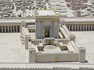
The Second Temple was the reconstructed Temple in Jerusalem, in use between c. 516 BCE and its destruction in 70 CE. In its last phase it was enhanced by Herod the Great, the result being later called Herod's Temple. Defining the Second Temple period, it stood as a pivotal symbol of Jewish identity and was central to Second Temple Judaism; it was the chief place of worship, ritual sacrifice (korban), and communal gathering for Jews. As such, it attracted Jewish pilgrims from distant lands during the Three Pilgrimage Festivals: Passover, Shavuot, and Sukkot.

The Cave of the Patriarchs or Tomb of the Patriarchs, known to Jews by its Biblical name Cave of Machpelah and to Muslims as the Sanctuary of Abraham, is a series of caves situated 30 kilometres (19 mi) south of Jerusalem in the heart of the Old City of Hebron in the West Bank. According to the Abrahamic religions, the cave and adjoining field were purchased by Abraham as a burial plot, although most historians believe the Abraham-Isaac-Jacob narrative to be primarily mythological. The site is considered a holy place in Judaism, Christianity, and Islam.

An ossuary is a chest, box, building, well, or site made to serve as the final resting place of human skeletal remains. They are frequently used where burial space is scarce. A body is first buried in a temporary grave, then after some years the skeletal remains are removed and placed in an ossuary. The greatly reduced space taken up by an ossuary means that it is possible to store the remains of many more people in a single tomb than possible in coffins. The practice is sometimes known as grave recycling.

Qumran is an archaeological site in the West Bank managed by Israel's Qumran National Park. It is located on a dry marl plateau about 1.5 km (1 mi) from the northwestern shore of the Dead Sea, about 10 km (6 mi) south of the historic city of Jericho, and adjacent to the modern Israeli settlement and kibbutz of Kalya.

The archaeology of Israel is the study of the archaeology of the present-day Israel, stretching from prehistory through three millennia of documented history. The ancient Land of Israel was a geographical bridge between the political and cultural centers of Mesopotamia and Egypt.

Herodion, Herodium (Latin), or Jabal al-Fureidis is an ancient fortress located 12 kilometres (7.5 mi) south of Jerusalem and 5 kilometres (3.1 mi) southeast of Bethlehem. It is located between the villages of Beit Ta'mir, Za'atara and Jannatah. It is identified with the site of Herodium, built by King of Judea Herod the Great between 23 and 15 BCE. Herodium is 758 meters (2,487 ft) above sea level.

Gamla, also Gamala, was an ancient Jewish town on the Golan Heights. Believed to have been founded as a Seleucid fort during the Syrian Wars, it transitioned into a predominantly Jewish settlement that came under Hasmonean rule in 81 BCE. The town's name reflects its location on a high, elongated ridge with steep slopes resembling a camel's hump.

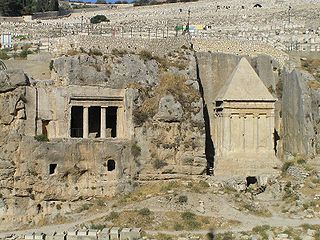
The Tomb of Absalom, also called Absalom's Pillar, is an ancient monumental rock-cut tomb with a conical roof located in the Kidron Valley in Jerusalem, a few metres from the Tomb of Zechariah and the Tomb of Benei Hezir. Although traditionally ascribed to Absalom, the rebellious son of King David of Israel, recent scholarship has dated it to the 1st century AD.

Judaea was a Roman province from 6 to 132 AD, which incorporated the Levantine regions of Idumea, Philistia, Judea, Samaria, and Galilee, extending over parts of the former regions of the Hasmonean and Herodian kingdoms of Judea. The name Judaea was derived from the Iron Age Kingdom of Judah, that was centered predominantly in Judea.

Maresha was an Iron Age city mentioned in the Hebrew Bible, whose remains have been excavated at Tell Sandahanna, an archaeological mound or 'tell' renamed after its identification to Tel Maresha. The ancient Judahite city became Idumaean after the fall of Judah in 586 BCE, and after Alexander's conquest of the region in 332 BCE became Hellenised under the name Marisa or Marissa. The tell is situated in Israel's Shephelah region, i.e. in the foothills of the Judaean Mountains, about 1.5 kilometres (0.93 mi) south of Beit Gubrin.

Beit She'arim Necropolis is an extensive rock-cut necropolis located near the ancient Jewish town of Beit She'arim, 20 km east of Haifa in the southern foothills of the Lower Galilee. Part of Beit She'arim National Park, the site includes the necropolis and remains of the town. Used from the first to fourth centuries CE, its peak occurred in the late second century when the Sanhedrin, led by Patriarch Judah I, relocated to Beit She'arim, and his family was interred there. In 2015, the necropolis was designated a UNESCO World Heritage Site.

The Second Temple period or post-exilic period in Jewish history denotes the approximately 600 years during which the Second Temple stood in the city of Jerusalem. It began with the return to Zion and subsequent reconstruction of the Temple in Jerusalem, and ended with the First Jewish–Roman War and the Roman siege of Jerusalem.

Jerusalem during the Second Temple period describes the history of the city during the existence there of the Second Temple, from the return to Zion under Cyrus the Great to the siege and destruction the city by Titus during the First Jewish–Roman War in 70 CE. During this period, which saw the region and city change hands several times, Jerusalem was the center of religious life for all Jews; even those who lived in the diaspora prayed towards Jerusalem on a daily basis and went there on pilgrimage during three annual religious festivals. Under Hasmonean and Herodian rule, Jerusalem served as a royal capital and the seat of all major national institutions. In Jerusalem, the Pharisees of Second Temple Judaism developed into the Tannaim and Judaism's post-Exilic religious identity as it continues today, and the Hebrew Bible was perhaps canonized, although exactly when this occurred remains disputed. It was also in Jerusalem during the later stages of this period that Christianity was born.

Ancient synagogues in Israel refers to synagogues located in Israel built by communities of Jews and Samaritans from antiquity to the Early Islamic period.
Khirbet el-Qom is an archaeological site in the village of al-Kum, West Bank, in the territory of the biblical Kingdom of Judah, between Lachish and Hebron, 14 km (8.7 mi) to the west of the latter.

Hyrcania was an ancient fortress in the Judean Desert. It was built by Hasmonean ruler John Hyrcanus or his son Alexander Jannaeus in the 2nd or 1st century BCE.
Ancient synagogues in Palestine refers to synagogues and their remains in the Land of Israel/Palestine region, built by the Jewish and Samaritan communities from the time of the Hasmonean dynasty during the Late Hellenistic period, to the Late Byzantine period.

