Koryciny is a village in the administrative district of Gmina Grodzisk, within Siemiatycze County, Podlaskie Voivodeship, in north-eastern Poland. It lies approximately 8 kilometres (5 mi) north of Grodzisk, 27 km (17 mi) north of Siemiatycze, and 60 km (37 mi) south-west of the regional capital Białystok.
Niegłowice is a village in the administrative district of Gmina Jasło, within Jasło County, Subcarpathian Voivodeship, in south-eastern Poland. It lies approximately 2 kilometres (1 mi) south of Jasło and 51 km (32 mi) southwest of the regional capital Rzeszów.
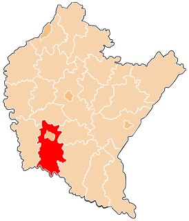
Machnówka is a village in the administrative district of Gmina Chorkówka, within Krosno County, Subcarpathian Voivodeship, in south-eastern Poland. It lies approximately 3 kilometres (2 mi) east of Chorkówka, 5 km (3 mi) south-west of Krosno, and 48 km (30 mi) south-west of the regional capital Rzeszów.
Jasionka is a village in the administrative district of Gmina Dukla, within Krosno County, Subcarpathian Voivodeship, in south-eastern Poland, close to the border with Slovakia. It lies approximately 5 kilometres (3 mi) south-east of Dukla, 15 km (9 mi) south of Krosno, and 58 km (36 mi) south of the regional capital Rzeszów.
Wilsznia is a village in the administrative district of Gmina Dukla, within Krosno County, Subcarpathian Voivodeship, in south-eastern Poland, close to the border with Slovakia. It lies approximately 12 kilometres (7 mi) south of Dukla, 26 km (16 mi) south of Krosno, and 68 km (42 mi) south of the regional capital Rzeszów.
Chlebna is a village in the administrative district of Gmina Jedlicze, within Krosno County, Subcarpathian Voivodeship, in south-eastern Poland. It lies approximately 10 km (6 mi) north-west of Krosno and 45 km (28 mi) south-west of the regional capital Rzeszów.
Długie is a village in the administrative district of Gmina Jedlicze, within Krosno County, Subcarpathian Voivodeship, in south-eastern Poland. It lies approximately 2 kilometres (1 mi) south of Jedlicze, 8 km (5 mi) west of Krosno, and 45 km (28 mi) south-west of the regional capital Rzeszów.
Dobieszyn is a village in the administrative district of Gmina Jedlicze, within Krosno County, Subcarpathian Voivodeship, in south-eastern Poland. It lies approximately 4 kilometres (2 mi) south-east of Jedlicze, 5 km (3 mi) west of Krosno, and 45 km (28 mi) south-west of the regional capital Rzeszów.
Moderówka is a village in the administrative district of Gmina Jedlicze, within Krosno County, Subcarpathian Voivodeship, in south-eastern Poland. It lies approximately 6 kilometres (4 mi) north of Jedlicze, 13 km (8 mi) north-west of Krosno, and 40 km (25 mi) south-west of the regional capital Rzeszów.
Piotrówka is a village in the administrative district of Gmina Jedlicze, within Krosno County, Subcarpathian Voivodeship, in south-eastern Poland. It lies approximately 4 kilometres (2 mi) south-west of Jedlicze, 11 km (7 mi) west of Krosno, and 48 km (30 mi) south-west of the regional capital Rzeszów.
Podniebyle is a village in the administrative district of Gmina Jedlicze, within Krosno County, Subcarpathian Voivodeship, in south-eastern Poland. It lies approximately 5 kilometres (3 mi) south-west of Jedlicze, 10 km (6 mi) west of Krosno, and 48 km (30 mi) south-west of the regional capital Rzeszów.
Potok is a village in the administrative district of Gmina Jedlicze, within Krosno County, Subcarpathian Voivodeship, in south-eastern Poland. It lies approximately 3 kilometres (2 mi) east of Jedlicze, 7 km (4 mi) north-west of Krosno, and 42 km (26 mi) south-west of the regional capital Rzeszów.
Bajdy is a village in the administrative district of Gmina Wojaszówka, within Krosno County, Subcarpathian Voivodeship, in south-eastern Poland. It lies approximately 3 kilometres (2 mi) south-west of Wojaszówka, 12 km (7 mi) north-west of Krosno, and 39 km (24 mi) south-west of the regional capital Rzeszów.
Rękawczyn is a village in the administrative district of Gmina Gozdowo, within Sierpc County, Masovian Voivodeship, in east-central Poland. It lies approximately 3 kilometres (2 mi) north-west of Gozdowo, 17 km (11 mi) south of Sierpc, and 109 km (68 mi) north-west of Warsaw.
Koperno is a village in the administrative district of Gmina Gubin, within Krosno Odrzańskie County, Lubusz Voivodeship, in western Poland, close to the German border. It lies approximately 8 kilometres (5 mi) south of Gubin, 31 km (19 mi) south-west of Krosno Odrzańskie, and 54 km (34 mi) west of Zielona Góra.
Kozów is a village in the administrative district of Gmina Gubin, within Krosno Odrzańskie County, Lubusz Voivodeship, in western Poland, close to the German border. It lies approximately 12 kilometres (7 mi) south of Gubin, 33 km (21 mi) south-west of Krosno Odrzańskie, and 54 km (34 mi) west of Zielona Góra.
Markosice is a village in the administrative district of Gmina Gubin, within Krosno Odrzańskie County, Lubusz Voivodeship, in western Poland, close to the German border. It lies approximately 11 kilometres (7 mi) south-west of Gubin, 36 km (22 mi) south-west of Krosno Odrzańskie, and 60 km (37 mi) west of Zielona Góra.
Siedliska is a village in the administrative district of Gmina Dąbrowa, within Opole County, Opole Voivodeship, in south-western Poland. It lies approximately 4 kilometres (2 mi) south of Dąbrowa and 15 km (9 mi) west of the regional capital Opole.