Gmina Chorkówka is a rural gmina in Krosno County, Subcarpathian Voivodeship, in south-eastern Poland. Its seat is the village of Chorkówka, which lies approximately 7 kilometres (4 mi) south-west of Krosno and 49 km (30 mi) south-west of the regional capital Rzeszów.
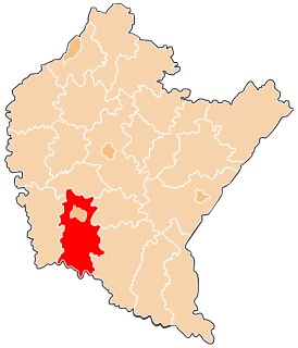
Gmina Wojaszówka is a rural gmina in Krosno County, Subcarpathian Voivodeship, in south-eastern Poland. Its seat is the village of Wojaszówka, which lies approximately 13 kilometres (8 mi) north-west of Krosno and 37 km (23 mi) south-west of the regional capital Rzeszów.

Niegłowice is a village in the administrative district of Gmina Jasło, within Jasło County, Subcarpathian Voivodeship, in south-eastern Poland. It lies approximately 2 kilometres (1 mi) south of Jasło and 51 km (32 mi) southwest of the regional capital Rzeszów.
Sulistrowa is a village in the administrative district of Gmina Chorkówka, within Krosno County, Subcarpathian Voivodeship, in south-eastern Poland. It lies approximately 7 kilometres (4 mi) south-west of Chorkówka, 13 km (8 mi) south-west of Krosno, and 55 km (34 mi) south-west of the regional capital Rzeszów.
Szczepańcowa is a village in the administrative district of Gmina Chorkówka, within Krosno County, Subcarpathian Voivodeship, in south-eastern Poland. It lies approximately 4 kilometres (2 mi) north of Chorkówka, 4 km (2 mi) west of Krosno, and 45 km (28 mi) south-west of the regional capital Rzeszów.
Chlebna is a village in the administrative district of Gmina Jedlicze, within Krosno County, Subcarpathian Voivodeship, in south-eastern Poland. It lies approximately 10 km (6 mi) north-west of Krosno and 45 km (28 mi) south-west of the regional capital Rzeszów.
Długie is a village in the administrative district of Gmina Jedlicze, within Krosno County, Subcarpathian Voivodeship, in south-eastern Poland. It lies approximately 2 kilometres (1 mi) south of Jedlicze, 8 km (5 mi) west of Krosno, and 45 km (28 mi) south-west of the regional capital Rzeszów.
Dobieszyn is a village in the administrative district of Gmina Jedlicze, within Krosno County, Subcarpathian Voivodeship, in south-eastern Poland. It lies approximately 4 kilometres (2 mi) south-east of Jedlicze, 5 km (3 mi) west of Krosno, and 45 km (28 mi) south-west of the regional capital Rzeszów.
Jaszczew is a village in the administrative district of Gmina Jedlicze, within Krosno County, Subcarpathian Voivodeship, in south-eastern Poland. It lies approximately 2 kilometres (1 mi) north of Jedlicze, 10 km (6 mi) north-west of Krosno, and 42 km (26 mi) south-west of the regional capital Rzeszów.
Moderówka is a village in the administrative district of Gmina Jedlicze, within Krosno County, Subcarpathian Voivodeship, in south-eastern Poland. It lies approximately 6 kilometres (4 mi) north of Jedlicze, 13 km (8 mi) north-west of Krosno, and 40 km (25 mi) south-west of the regional capital Rzeszów.
Piotrówka is a village in the administrative district of Gmina Jedlicze, within Krosno County, Subcarpathian Voivodeship, in south-eastern Poland. It lies approximately 4 kilometres (2 mi) south-west of Jedlicze, 11 km (7 mi) west of Krosno, and 48 km (30 mi) south-west of the regional capital Rzeszów.
Potok is a village in the administrative district of Gmina Jedlicze, within Krosno County, Subcarpathian Voivodeship, in south-eastern Poland. It lies approximately 3 kilometres (2 mi) east of Jedlicze, 7 km (4 mi) north-west of Krosno, and 42 km (26 mi) south-west of the regional capital Rzeszów.
Niżna Łąka is a village in the administrative district of Gmina Miejsce Piastowe, within Krosno County, Subcarpathian Voivodeship, in south-eastern Poland. It lies approximately 8 kilometres (5 mi) south of Krosno and 51 km (32 mi) south-west of the regional capital Rzeszów.
Wróblik Królewski is a village in the administrative district of Gmina Rymanów, within Krosno County, Subcarpathian Voivodeship, in south-eastern Poland. It lies approximately 6 kilometres (4 mi) north of Rymanów, 12 km (7 mi) south-east of Krosno, and 48 km (30 mi) south of the regional capital Rzeszów.

Wróblik Szlachecki is a village in the administrative district of Gmina Rymanów, within Krosno County, Subcarpathian Voivodeship, in south-eastern Poland. It lies approximately 6 kilometres (4 mi) north of Rymanów, 13 km (8 mi) south-east of Krosno, and 48 km (30 mi) south of the regional capital Rzeszów.
Pietrusza Wola is a village in the administrative district of Gmina Wojaszówka, within Krosno County, Subcarpathian Voivodeship, in south-eastern Poland. It lies approximately 4 kilometres (2 mi) north of Wojaszówka, 16 km (10 mi) north of Krosno, and 34 km (21 mi) south-west of the regional capital Rzeszów. Its approximate population is 300.
Wojaszówka is a village in Krosno County, Subcarpathian Voivodeship, in south-eastern Poland. It is the seat of the gmina called Gmina Wojaszówka. It lies approximately 13 kilometres (8 mi) north-west of Krosno and 37 km (23 mi) south-west of the regional capital Rzeszów.
Strzegów is a village in the administrative district of Gmina Gubin, within Krosno Odrzańskie County, Lubusz Voivodeship, in western Poland, close to the German border. It lies approximately 17 kilometres (11 mi) south-west of Gubin, 41 km (25 mi) south-west of Krosno Odrzańskie, and 63 km (39 mi) west of Zielona Góra.