
The Grisons or Graubünden, more formally the Canton of the Grisons or the Canton of Graubünden, is one of the twenty-six cantons of Switzerland. It has eleven districts, and its capital is Chur. The German name of the canton, Graubünden, translates as the "Grey Leagues", referring to the canton's origin in three local alliances, the Three Leagues. The other native names also refer to the Grey League: Grischùn in Sutsilvan, Grischun in the other forms of Romansh, and Grigioni in Italian. Rhaetia is the Latin name for the area. The Alpine ibex is the canton's heraldic symbol.

Valais, more formally, the Canton of Valais, is one of the 26 cantons forming the Swiss Confederation. It is composed of thirteen districts and its capital and largest city is Sion.

The Simplon Pass is a high mountain pass between the Pennine Alps and the Lepontine Alps in Switzerland. It connects Brig in the canton of Valais with Domodossola in Piedmont (Italy). The pass itself and the villages on each side of it, such as Gondo, are in Switzerland. The Simplon Tunnel was built beneath the vicinity of the pass in the early 20th century to carry rail traffic between the two countries.

Piz Bernina is the highest mountain in the Eastern Alps, the highest point of the Bernina Range, and the highest peak in the Rhaetian Alps. It rises 4,048 m (13,281 ft) and is located south of Pontresina in the Bernina Region and near the major Alpine resort of St. Moritz, in the Engadin valley. It is also the most easterly mountain higher than 4,000 m (13,000 ft) in the Alps, the highest point of the Swiss canton of Grisons, and the fifth-most prominent peak in the Alps. Although the summit lies within Switzerland, the massif is on the border with Italy. The "shoulder" known as La Spedla is the highest point in the Italian Lombardy region.

The Bernese Oberland, sometimes also known as the Bernese Highlands, is the highest and southernmost part of the canton of Bern. It is one of the canton's five administrative regions. It constitutes the Alpine region of the canton and the northern side of the Bernese Alps, including many of its highest peaks, among which the Finsteraarhorn, the highest in both range and canton.

The Bernina Pass is a high mountain pass in the Bernina Range of the Alps, in the canton of Graubünden (Grisons) in eastern Switzerland. It connects the famous resort town of St. Moritz in the Engadin valley with the Italian-speaking Val Poschiavo, which ends in the Italian town of Tirano in Valtellina. The pass lies a few kilometres east of Piz Bernina, and south of Val Minor.

Nufenen Pass is the second highest mountain pass with a paved road in Switzerland, with an elevation of 2,478 metres. It lies between the summits of Pizzo Gallina (north) and the Nufenenstock (south). The road opened to motor vehicle traffic in September 1969.

Lukmanier Pass is a pass in the Swiss Alps.
The Flüela Pass is a high mountain pass of the Swiss Alps in Graubünden. Traditionally considered the boundary between the Albula and Silvretta Alps, the pass crosses the watershed / drainage divide between the basins of the rivers Rhine and Danube. The pass is overlooked by the Flüela Schwarzhorn and the Flüela Wisshorn. The summit of the pass lies between the lakes Lai da la Scotta and Lai Nair.

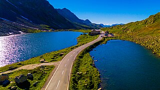
Maloja Pass is a high mountain pass in the Swiss Alps in the canton of Graubünden, linking the Engadine with the Val Bregaglia, still in Switzerland and Chiavenna in Italy. It marks the divide between the Danube and Po watersheds. Lägh da Bitabergh is near the pass.

Klausen Pass is a high mountain pass in the Swiss Alps connecting Altdorf in the canton of Uri with Linthal in the canton of Glarus. Somewhat unusually, the boundary between the two cantons does not lie at the summit of the pass, but some 8 kilometres (5.0 mi) down the slope towards Linthal, with the summit being in Uri.

Oberalp Pass is a high mountain pass in the Swiss Alps connecting the cantons of Graubünden and Uri between Disentis/Mustér and Andermatt.

Susten Pass is a mountain pass in the Swiss Alps. The pass road, built from 1938–1945, connects Innertkirchen in the canton of Bern with Wassen in the canton of Uri. A 300-metre long tunnel crosses the pass at 2,224 metres.
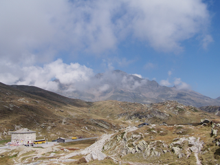
San Bernardino Pass is a high mountain pass in the Swiss Alps connecting the Hinterrhein and the Mesolcina (Misox) valleys between Thusis and Bellinzona. Located in the far eastern side of the Western Alps it is not to be confused with the Great St Bernard Pass and the Little St Bernard Pass. The top of the pass represents both the Italo-German language frontier and the watershed between the Po basin and the Rhine basin. Marscholsee is within the pass at an elevation of 2,053 m (6,736 ft).

Boltigen is a municipality in the Obersimmental-Saanen administrative district in the canton of Bern in Switzerland.

Jaun is a municipality in the district of Gruyère in the canton of Fribourg in Switzerland. It is the only German-speaking municipality in Gruyère.
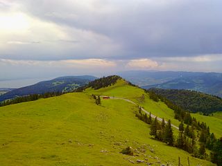
Chasseral Pass is a high mountain pass in the Jura Mountains, lying west of the Chasseral. The pass is located on the border between the Swiss cantons of Neuchâtel and Bern. It is traversed by a road connecting Saint-Imier and Nods, both located in the Bernese Jura. North-east of the pass is the Chasseral Ouest, the highest point of the canton of Neuchâtel.

Lac de Montsalvens is a reservoir in the Canton of Fribourg, Switzerland. The reservoir has a capacity of 12.6 million m³ and a surface area of 0.74 km2 (0.29 sq mi). It was built on the Jogne river, before the gorges, and below the road to Jaun Pass, between the villages of Broc and Charmey.

The Galenstock is the fourth highest mountain in the Urner Alps in Switzerland. Its summit ridge lies on the border between the cantons of Uri and the Valais.
The Schafberg is a mountain peak above Boltigen located on the border between the cantons of Fribourg and Bern, north of Jaun. With a height 2,239 metres above sea level, it is the highest summit on the range lying north of the Jaun Pass. It is also the most isolated mountain in the canton of Fribourg.

