Hawick is a town in the Scottish Borders council area and historic county of Roxburghshire in the east Southern Uplands of Scotland. It is 10 miles (16.1 km) south-west of Jedburgh and 8.9 miles (14.3 km) south-south-east of Selkirk. It is one of the furthest towns from the sea in Scotland, in the heart of Teviotdale, and is the biggest town in Roxburghshire. The town is at the confluence of the Slitrig Water with the River Teviot.

Jedburgh is a town and former royal burgh in the Scottish Borders and the traditional county town of the historic county of Roxburghshire.
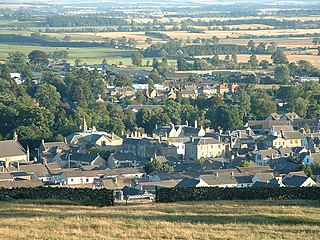
Duns is a town in the Scottish Borders, Scotland. It was the county town of the historic county of Berwickshire.

Hermitage Castle is a semi-ruined castle in the border region of Scotland. It stands in the remote valley of the Hermitage Water, part of Liddesdale in Roxburghshire. It is under the care of Historic Scotland. The castle has a reputation, both from its history and its appearance, as one of the most sinister and atmospheric castles in Scotland.

St Mary's Abbey, Melrose is a partly ruined monastery of the Cistercian order in Melrose, Roxburghshire, in the Scottish Borders. It was founded in 1136 by Cistercian monks at the request of King David I of Scotland and was the chief house of that order in the country until the Reformation. It was headed by the abbot or commendator of Melrose. Today the abbey is maintained by Historic Environment Scotland as a scheduled monument.
The Raid of the Redeswire, also known as the Redeswire Fray, was a border skirmish between England and Scotland on 7 July 1575 which took place at Carter Bar, the Cheviot pass which enters Redesdale. The skirmish was between the English Warden of the Middle Marches, Sir John Forster, with Sir George Heron, Keeper of Redesdale, Keeper of Liddesdale and Scottish Warden and Sir John Carmichael, the Lord Warden of the Marches, with George Douglas of Bonjedworth. It was the last battle between the Kingdom of England and the Kingdom of Scotland.

The Canongate is a street and associated district in central Edinburgh, the capital city of Scotland. The street forms the main eastern length of the Royal Mile while the district is the main eastern section of Edinburgh's Old Town.

The Jed Water is a river and a tributary of the River Teviot in the Borders region of Scotland.
Roxburgh Castle is a ruined royal castle that overlooks the junction of the rivers Tweed and Teviot, in the Borders region of Scotland. The town and castle developed into the royal burgh of Roxburgh, which the Scots destroyed along with the castle after capturing it in 1460. Today the ruins stand in the grounds of Floors Castle, the seat of the Duke of Roxburghe, across the river from Kelso.

Ferniehirst Castle is an L-shaped construction on the east bank of the Jed Water, about a mile and a half south of Jedburgh, in the Scottish Borders area of Scotland, and in the former county of Roxburghshire. It is an ancient seat of the Clan Kerr, and after a period of institutional use it was restored for residential use by Peter Kerr, 12th Marquess of Lothian, in the late 20th century.

The Anglo-Scottish border is an internal border of the United Kingdom separating Scotland and England which runs for 96 miles (154 km) between Marshall Meadows Bay on the east coast and the Solway Firth in the west.

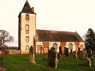
Bonkyl Church is a Church of Scotland kirk situated at grid reference NT808595 5 miles northeast of Duns in the old county of Berwickshire. The nearest hamlet is Preston just over 2 miles to the south-west.
Polwarth Parish Church was a member church of the Church of Scotland before closing in 2004. It is situated atop a mound off a minor road leading from the A6105, Greenlaw to Duns road in the old county of Berwickshire, now privately owned by the Letts family who live in the adjacent Polwarth Manse and is available for weddings. It lies 4.0 miles (6.4 km) south–west of Duns and 3.5 miles (5.6 km) east of Greenlaw at grid reference NT749494.
Ladykirk is a village on the B6470 in the Scottish Borders area of Scotland, and the former Berwickshire, just north of the River Tweed and the Anglo-Scottish border. The town was formerly known as Upsettlington, but King James IV of Scotland renamed the town Ladykirk; the church is also known as St Mary's Church or Kirk of Steill. Ladykirk stands directly opposite Norham Castle, Northumberland, England

Bonjedward is a hamlet in the Scottish Borders area of Scotland, two miles north of Jedburgh where the Jed Water joins the River Teviot.

Crailing is a village on the A698, in Teviotdale, 4m east of Jedburgh in the Scottish Borders area of Scotland, in the historic county of Roxburghshire.

Jedburgh Grammar School is a state secondary school in Jedburgh, Scotland, with around 440 pupils, 40 teaching staff, and 15 non-teaching staff.
Fulton Tower is a ruined 16th century tower house, about 4.5 miles (7.2 km) south west of Jedburgh, Scottish Borders, Scotland, and about 2 miles (3.2 km) south of Bedrule, east of the Rule Water.

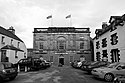
Jedburgh Sheriff Court, formerly County Buildings, is a judicial building in the Market Square in Jedburgh in Scotland. The building, which continues to be used as a courthouse, is a Category B listed building.