
Chester County, colloquially known as Chesco, is a county in the U.S. state of Pennsylvania. As of the 2010 census, the population was 498,886, increasing by 5.2% to a census-estimated 524,989 residents as of 2019. The county seat is West Chester. Chester County was one of the three original Pennsylvania counties created by William Penn in 1682. It was named for Chester, England.

Thornbury Township is a township in Chester County, Pennsylvania, United States. The population was 3,017 at the 2010 census. It is adjacent to, and was once joined with, Thornbury Township, Delaware County, Pennsylvania.

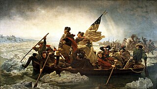
The Battle of Brandywine, also known as the Battle of Brandywine Creek, was fought between the American Continental Army of General George Washington and the British Army of General Sir William Howe on September 11, 1777, as part of the American Revolutionary War (1775-1783). The forces met near Chadds Ford, Pennsylvania, as Howe moved to take Philadelphia, then the American capital. The British forces routed the Continental Army and forced them to withdraw, first, to the City of Chester, Chester, Pennsylvania, and then northeast toward Philadelphia. More troops fought at Brandywine than any other battle of the American Revolution. It was also the longest single-day battle of the war, with continuous fighting for 11 hours.

Brandywine Creek is a tributary of the Christina River in southeastern Pennsylvania and northern Delaware in the United States. The Lower Brandywine is 20.4 miles (32.8 km) long and is a designated Pennsylvania Scenic River with several tributary streams. The East Branch and West Branch of the creek originate within 2 miles (3 km) of each other on the slopes of Welsh Mountain in Honey Brook Township, Pennsylvania, about 20 miles (32 km) northwest of their confluence.

Chadds Ford Township is an affluent township in Delaware County, Pennsylvania. It is located about 25 miles (40 km) southwest of Philadelphia. Prior to 1996, Chadds Ford Township was known as Birmingham Township; the name was changed to allow the township to correspond to both its census-designated place and to distinguish itself from the adjacent Birmingham Township in Chester County. As of the 2010 census, Chadds Ford Township had a population of 3,640, up from 3,170 at the 2000 census.

Hezekiah Niles, was an American editor and publisher of the Baltimore-based national weekly news magazine, Niles' Weekly Register and the Weekly Register.
Pennsylvania was the site of key events and places related to the American Revolution. The state, and especially the city of Philadelphia, played a critical role in the American Revolution.

Willowdale is a small, unincorporated community located in East Marlborough Township, in southern Chester County, Pennsylvania.

Brandywine Battlefield Historic Site is a National Historical Landmark. The historic park is owned and operated by the Pennsylvania Historical and Museum Commission, on 52 acres (210,000 m2), near Chadds Ford, Delaware County, Pennsylvania in the United States. It is part of the site of the Battle of Brandywine fought on September 11, 1777, during the American Revolution. The Battle of Brandywine covered more than ten square miles, or 35,000 acres. However, the modern park only covers 50 acres which served primarily as the Continental encampment the two days prior to the battle. The battle was a decisive victory for the British and cleared a path directly to the rebel capital of Philadelphia. Brandywine Battlefield Park became a Pennsylvania State Park in 1949 and a National Historic Landmark in 1961.
The Battle of the Clouds was an aborted engagement of the Philadelphia campaign of the American Revolutionary War on September 16, 1777, in the area surrounding present day Malvern, Pennsylvania. After the American defeat at the Battle of Brandywine, the British Army remained encamped near Chadds Ford. When British commander William Howe was informed that the weakened American force was less than ten miles (16 km) away, he decided to press for another decisive victory.

The N. C. Wyeth House and Studio is a historic house museum and artist's studio on Murphy Road in Chadds Ford Township, Pennsylvania, United States. Beginning with its construction in 1911, it served as the principal home and studio of artist N.C. Wyeth (1882-1945). It was restored to its original appearance around the time of his death. The property is managed by the Brandywine River Museum, which offers tours. It was designated a National Historic Landmark District in 1997.

Star Gazers' Stone located on Star Gazers' Farm near Embreeville, Pennsylvania, USA, marks the site of a temporary observatory established in January 1764 by Charles Mason and Jeremiah Dixon which they used in their survey of the Mason-Dixon line. The stone was placed by Mason and Dixon about 700 feet (213 m) north of the Harlan House, which was used as a base of operations by Mason and Dixon through the four-and-a-half-year-long survey. Selected to be about 31 miles (50 km) west of the then southernmost point in Philadelphia, the observatory was used to determine the precise latitude of its location. The latitude of the Maryland-Pennsylvania border was then set to be 15 miles (24.1 km) south of the point in Philadelphia. The farm, including the house and stone, were listed on the National Register of Historic Places on May 9, 1985.
William Harris (1757–1812) was a farmer, soldier, and member of the Pennsylvania legislature. He was the father of two other American military men.

Richard Jacobs Baldwin was an American politician from Pennsylvania who served as a Republican member of the Pennsylvania House of Representatives in the 1894, 1896 and 1898 terms. He was reelected to the House for the 1910, 1912, 1914 and 1916 terms and served as Speaker of the Pennsylvania House of Representatives from 1917 to 1918. He was nominated speaker due to his twenty years of service in the house by the Republican political boss Boies Penrose. Baldwin also served a term in the Pennsylvania State Senate for the 9th Senatorial District from 1919 to 1920.
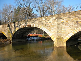
The Cope's Bridge is a stone arch bridge which carries Strasburg Road across the East Branch Brandywine Creek in East Bradford Township, Chester County, Pennsylvania. The bridge is listed on the National Register of Historic Places and is located at 39°57′31.9″N75°39′19.3″W. It is in the Taylor-Cope Historic District.

Trimbleville, Pennsylvania, also known as Trimble's Ford and the Trimbleville Historic District is a hamlet of about six homes, in southern Chester County, Pennsylvania, about two miles south of Marshallton.

Indian Hannah (1730–1802) was supposedly the last of the Lenni-Lenape Indians in Chester County, Pennsylvania, USA.

Painters Crossing is a historic area of Chadds Ford Township, Delaware County, Pennsylvania, near where U.S. Route 202 and U.S. Route 1 cross. The area is important in connection to the Revolutionary War battle at Brandywine.
John Hannum III, also known as Col. John Hannum was a politician, businessman and colonial militiaman in Chester County, Pennsylvania influential in the establishment of West Chester, Pennsylvania as the county seat. His grandfather was an early settler in Pennsylvania, perhaps immigrating as early as 1682.

The history of West Chester, Pennsylvania, began in 1762, when Phineas Eachus and Chest Weaterson were issued a license to build a tavern. The borough was incorporated in 1799. One of the nation's first railroads was built in West Chester in 1832, and a prominent courthouse, designed by Thomas U. Walter, was completed in 1847. The first biography of Abraham Lincoln was published in the borough. Thanks to the Sharples Separator Works, West Chester became a major industrial town at the turn of the 20th century. During World War II, West Chester produced more penicillin than anywhere else in the country.
