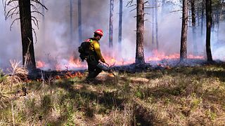
A controlled or prescribed (Rx) burn is the practice of intentionally setting a fire to change the assemblage of vegetation and decaying material in a landscape. The purpose could be for forest management, ecological restoration, land clearing or wildfire fuel management. A controlled burn may also refer to the intentional burning of slash and fuels through burn piles. Controlled burns may also be referred to as hazard reduction burning, backfire, swailing or a burn-off. In industrialized countries, controlled burning regulations and permits are usually overseen by fire control authorities.

Pyramid Lake is a reservoir formed by Pyramid Dam on Piru Creek in the eastern San Emigdio Mountains, near Castaic, Southern California. It is a part of the West Branch California Aqueduct, which is a part of the California State Water Project. Its water is fed by the system after being pumped up from the San Joaquin Valley and through the Tehachapi Mountains.

Donner Lake, formerly known as Truckee Lake, is a freshwater lake in Northeast California on the eastern slope of the Sierra Nevada and about 20 miles (32 km) northwest of the much larger Lake Tahoe. A moraine serves as a natural dam for the lake. The lake is located in the town of Truckee, between Interstate 80 to the north and Schallenberger Ridge to the south. The tracks of the Union Pacific Railroad run along Schallenberger Ridge and closely follow the route of the original transcontinental railroad. The historic route of the Lincoln Highway, the first automobile road across America and US 40 follows the northern shoreline, then climbs to Donner Pass from where the entire lake may be viewed.
Lake Sonoma is a reservoir west of Cloverdale in northern Sonoma County, California, created by the construction of Warm Springs Dam. The lake provides water for countywide growth and development, and for recreation.

Fire ecology is a scientific discipline concerned with the effects of fire on natural ecosystems. Many ecosystems, particularly prairie, savanna, chaparral and coniferous forests, have evolved with fire as an essential contributor to habitat vitality and renewal. Many plant species in fire-affected environments use fire to germinate, establish, or to reproduce. Wildfire suppression not only endangers these species, but also the animals that depend upon them.

Cache Creek is an 87-mile-long (140 km) stream in Lake, Colusa and Yolo counties, California.

Castaic Lake is a reservoir formed by Castaic Dam on Castaic Creek, in the Sierra Pelona Mountains of northwestern Los Angeles County, California, United States, near the town of Castaic.

Putah Creek is a major stream in Northern California, a tributary of the Yolo Bypass, and ultimately, the Sacramento River. The 85-mile-long (137 km) creek has its headwaters in the Mayacamas Mountains, a part of the Coast Range, and flows east through two dams. First, Monticello Dam forms Lake Berryessa, below which Putah Creek forms the border of Yolo and Solano Counties, and then flows to the Putah Diversion Dam and Lake Solano. After several drought years in the late 1980s, the majority of Putah Creek went dry, prompting a landmark lawsuit that resulted in the signing of the Putah Creek Accord in 2000. The Accord established releases from the dams to maintain stream flows in Putah Creek, with natural flow regimes which spike in winter/spring and ebb in summer/fall. The restoration of natural flow regimes has resulted in a doubling of riparian bird species and a return of spawning native steelhead trout and Chinook salmon, as well as protecting the livelihood of farmers on the lower watershed.

Folsom Lake is a reservoir on the American River in the Sierra Nevada foothills of California, United States. Folsom Lake with its surrounding Folsom Lake State Recreation Area is one of the most visited parks in the California park system.

The Sam Houston National Forest, one of four National Forests in Texas, is located 50 miles north of Houston. The forest is administered together with the other three United States National Forests and two National Grasslands located entirely in Texas, from common offices in Lufkin, Texas. The units include Angelina, Davy Crockett, Sabine, and Sam Houston National Forests, plus Caddo National Grassland and Lyndon B. Johnson National Grassland. There are local ranger district offices located in New Waverly. It is located in portions of three Texas counties including Montgomery, San Jacinto, and Walker.

Whiskeytown Lake is a reservoir in Shasta County in northwestern California, United States, about 8 miles (13 km) west of Redding. The lake is in the Whiskeytown Unit of the Whiskeytown-Shasta-Trinity National Recreation Area.

Lake Perris is an artificial lake completed in 1973. It is the southern terminus of the California State Water Project, situated in a mountain-rimmed valley between Moreno Valley and Perris, in what is now the Lake Perris State Recreation Area. The park offers a variety of recreational activities. Because of this and the lake's proximity to major population centers, it is very crowded during the summer months.
Lake Chabot is a man-made lake covering 317 acres (1.3 km2) in Alameda County, California, United States. Part of the lake lies within Oakland city limits, but most of it lies in unincorporated Castro Valley, just east of San Leandro. It was formed by the damming of San Leandro Creek. The lake was completed in 1875 to serve as a primary source of water for the East Bay.

Silverwood Lake is a large reservoir in San Bernardino County, California, United States, located on the West Fork Mojave River, a tributary of the Mojave River in the San Bernardino Mountains. It was created in 1971 as part of the State Water Project by the construction of the Cedar Springs Dam as a forebay on the 444 mi (715 km) long California Aqueduct, and has a capacity of 73,000 acre⋅ft (90,000,000 m3).

The San Pablo Reservoir is an open cut terminal water storage reservoir owned and operated by the East Bay Municipal Utility District (EBMUD). It is located in the valley of San Pablo Creek, north of Orinda, California, United States, and south of El Sobrante and Richmond, east of the Berkeley Hills between San Pablo Ridge and Sobrante Ridge.

Englebright Lake is an 815 acre reservoir on the Yuba River, impounded by Englebright Dam, in the Sierra Nevada, Northern California, United States. The reservoir stores 45,000 acre feet of water with nearly 24 miles of shoreline.

French Meadows Reservoir is a manmade lake 36 miles (58 km) northeast of Foresthill, California, United States on the Middle Fork of the American River. The reservoir is 2.9 miles (4.7 km) long, 0.6-mile (0.97 km) wide, with 7.3 miles (11.7 km) of shoreline.

The Lafayette Reservoir is an open-cut human-made terminal water storage reservoir owned and operated by the East Bay Municipal Utility District (EBMUD). Completed in 1933, it was intended solely as a standby water supply for EBMUD customers. EBMUD opened the reservoir for public recreation in 1966. It is located off of California State Route 24 and a mile from the Lafayette BART station, in Contra Costa County, California, United States. This all-year, day-use area is ideal for hiking, jogging, fishing, boating and picnicking. The reservoir is on the Lafayette-Orinda border. The reservoir is on a 925-acre (3.74 km2) site and holds 1.4 billion US gallons (5,300,000 m3)

Sly Park Dam is located near Pollock Pines, California in the United States. The dam impounds Sly Park Creek and Hazel Creek, natural tributaries of the North Fork Cosumnes River, to form a 41,000 acre-foot (51,000 dam3), 650-acre (260 ha) reservoir called Jenkinson Lake. It was constructed as part of the American River Division of the Central Valley Project to provide irrigation water to a portion of El Dorado County, California. The dam was begun in May 1953, with clearing operations, and was completed in mid 1955.

The Cameron Peak fire was a wildfire that started near Chambers Lake, Colorado, 25 miles (40 km) east of Walden and 15 miles (24 km) southwest of Red Feather Lakes near Cameron Pass on August 13, 2020, and was declared 100% contained on December 2, 2020. The fire burnt 208,663 acres through the Arapaho and Roosevelt National Forests in Larimer and Jackson Counties and Rocky Mountain National Park. At its peak, the fire forced the evacuation of over 6,000 residents in Estes Park, Chambers Lake, Rustic, Glacier View Meadows, Red Feather Lakes, Masonville, Glen Haven, Spring Canyon, various small communities along Highway 14, Stove Prairie Landing Road, as well as the Colorado State University Mountain Campus and had over 1,000 personnel fighting the fire. 469 structures were destroyed by the fire, including 220 outbuildings and 42 primary residences. The fire became the largest wildfire in Colorado history, surpassing the Pine Gulch Fire, which had set the same mark just seven weeks prior.


