Related Research Articles

Garrett County is the westernmost county of the U.S. state of Maryland. As of the 2020 census, the population was 28,806, making it the third-least populous county in Maryland. Its county seat is Oakland. The county was named for John Work Garrett (1820–1884), president of the Baltimore and Ohio Railroad. Created from Allegany County, Maryland in 1873, it was the last Maryland county to be formed.
Allegany County is located in the northwestern part of the U.S. state of Maryland. As of the 2020 census, the population was 68,106. Its county seat is Cumberland. The name Allegany may come from a local Lenape word, welhik hane or oolikhanna, which means 'best flowing river of the hills' or 'beautiful stream'. A number of counties and a river in the Appalachian region of the U.S. are named Allegany, Allegheny, or Alleghany. Allegany County is part of the Cumberland, MD-WV Metropolitan Statistical Area. It is a part of the Western Maryland "panhandle".
Georges Creek is a 17.6-mile-long (28.3 km) tributary stream of the North Branch Potomac River in western Maryland. The creek has its headwaters on Savage Mountain near Frostburg and empties into the North Branch Potomac River at Westernport, all in western Allegany County. Along the Georges Creek Valley, there exists a series of small towns founded in the nineteenth century for miners' homes. The Georges Creek Valley is rich in wide veins of coal, once extracted by deep mines but still mined today through surface mining.
Wills Creek is a 38.6-mile-long (62.1 km) tributary of the North Branch Potomac River in Pennsylvania and Maryland in the United States.
Maryland Route 36 is a 29.43-mile (47.36 km) state highway located in Allegany County, Maryland, United States. MD 36's southern terminus is at the West Virginia Route 46 (WV 46) bridge in Westernport and its northern terminus at U.S. Route 40 Alternate near Cumberland. Between Westernport and Frostburg, it is known as Georges Creek Road, and from Frostburg to Cumberland it is known as Mount Savage Road. Like the majority of Maryland state highways, MD 36 is maintained by the Maryland State Highway Administration (MDSHA).

Mount Savage is an unincorporated community and census-designated place (CDP) in Allegany County, Maryland, United States. As of the 2010 census it had a population of 873.
Corriganville is an unincorporated community and census-designated place (CDP) in Allegany County, Maryland, United States. As of the 2010 census it had a population of 455. Corriganville is part of the Cumberland, MD-WV Metropolitan Statistical Area.

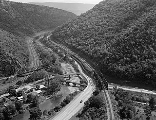
Wills Mountain is a quartzite-capped ridge in the Ridge and Valley physiographic province of the Appalachian Mountains in Pennsylvania and Maryland, United States, extending from near Bedford, Pennsylvania, to near Cumberland, Maryland. It is the northernmost of several mountain ridges included within the Wills Mountain Anticline.

The Maryland Mining Company is a historic coal mining, iron producer and railroad company that operated in Allegany County, Maryland.
The Eckhart Branch Railroad is a railroad that operated in the Cumberland, Maryland area in the 19th century.
The Mount Savage Railroad was a railroad operated by the Maryland and New York Coal and Iron Company of Mount Savage, Maryland between 1845 and 1854. The 14.9 miles (24 km) rail line ran from Frostburg to Cumberland, Maryland.

Maryland Route 35 is a state highway in the U.S. state of Maryland. Known as Ellerslie Road, the state highway runs 2.37 miles (3.81 km) from MD 36 in Corriganville north to the Pennsylvania state line in Ellerslie, where the highway continues north as Pennsylvania Route 96. MD 35 was constructed in the late 1910s and was one of the original signed state highways in 1927. The state highway runs through the valley of Wills Creek, an important passage for the railroads beginning in the mid 19th century.

Maryland Route 638 is a state highway in the U.S. state of Maryland. Known as Parkersburg Road, the state highway runs 2.34 miles (3.77 km) from MD 743 in Eckhart Mines north to MD 36 near Mount Savage in northwestern Allegany County. MD 638 was constructed in the late 1930s.

Maryland Route 47 is a state highway in the U.S. state of Maryland. Known as Barrelville Road, the state highway runs 1.67 miles (2.69 km) from MD 36 in Barrelville north to the Pennsylvania state line, where the highway continues north as Pennsylvania Route 160. While it is a minor route today, MD 47 was once part of the main highway between Cumberland and Somerset, Pennsylvania. The state highway was constructed in its modern form in the early 1920s.
Allegany County Public Schools is a public school district serving Allegany County, Maryland.
U.S. Route 40 Alternate is the U.S. Highway designation for a former segment of U.S. Route 40 (US 40) through Garrett and Allegany counties in Maryland. The highway begins at US 40 near exit 14 on Interstate 68 (I-68) and runs 31.80 miles (51.18 km) eastward to Cumberland, where it ends at exit 44 on I-68. Alt US 40 is maintained by the Maryland State Highway Administration (MDSHA).

Barrelville is an unincorporated community and census-designated place (CDP) in Allegany County, Maryland, United States. As of the 2010 census, it had a population of 73. It is located between Corriganville and Mount Savage, where an 1804 road from Pennsylvania intersected the legendary Turkey Foot Road. Jennings Run flows from Mount Savage to Barrelville, where another tributary that runs south from Wellersburg, Pennsylvania, joins Jennings Run.
Narrows Park is an unincorporated community in Allegany County, Maryland, United States. Braddock Run flows into Wills Creek near Narrows Park.

The North Branch Potomac River flows from Fairfax Stone in West Virginia to its confluence with the South Branch Potomac River near Green Spring, West Virginia, where it turns into the Potomac River proper.
References
- 1 2 3 Parker, Willis, Bolster, Ashe, & Marsh, Horatio N., Bailey, R.H., W.W., & M.C. (1907). The Potomac River Basin. Washington, DC: Government Printing Office. p. 219. Retrieved June 22, 2020.CS1 maint: multiple names: authors list (link)