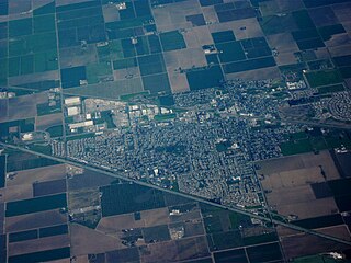
Dixon is a city in northern Solano County, California, United States, located 23 miles (37 km) from the state capital, Sacramento. It has a hot-summer mediterranean climate on the Köppen climate classification scale. Its population was 18,988 at the 2020 census. Other nearby cities include Vacaville, Winters, Davis, Woodland, and Rio Vista.

Solano County is a county located in the U.S. state of California. As of the 2020 census, its population was 453,491. The county seat is Fairfield.

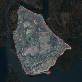
Maine Prairie is an unincorporated community located in Solano County, California east of Elmira, California on the Maine Prairie Slough at latitude 38.308 and longitude -121.759. The elevation is 7 feet (2.1 m). Maine Prairie appears on the Dozier U.S. Geological Survey Map.

The Hearst Ranch is composed of two cattle ranches in central California. The best known is the original Hearst Ranch, which surrounds Hearst Castle and comprises about 80,000 acres (320 km2). George Hearst (1820–1891) bought over 30,000 acres (120 km2) of Rancho Piedra Blanca, an 1840 Mexican land grant, in the late 19th century. He also bought most of Rancho San Simeon, and part of Rancho Santa Rosa, two other adjacent land grants.

Montezuma is a former hamlet and township in Solano County, California, located in the California Delta region of the state; the township, which embraced the hamlet, and several other places, such as Bird's Landing—which still exists—included portions of the Montezuma Hills. The name Montezuma was used in multiple places within Solano County by Mormon settlers during the period from 1847 to 1850.

Morrow Island is a small island located off the shore of Grizzly Bay in the San Francisco Bay Area of California. It is part of Solano County, California, and partially administered by Reclamation District 2138. Its coordinates are 38°07′00″N122°05′11″W. It has an elevation of 2 meters to 7 feet.
Tremont Township was a defunct portion of Solano County, California. It comprised the portions of Solano County opposite Putah Creek from Davisville. It appears on an 1890 map of Solano County.

Hammond Island is a small island in Suisun Bay, California. It is part of Solano County. Its coordinates are 38°06′18″N121°56′15″W. An 1850 survey map of the San Francisco Bay area made by Cadwalader Ringgold shows islands partially covering some of the current area of Hammond Island, labeled "Davis Island" and "Warrington Island".
Dutton Island is a small island in Suisun Bay, California. It is part of Solano County, and included within Reclamation District 2127. Its coordinates are 38°04′54″N121°58′14″W. An 1850 survey map of the San Francisco Bay area made by Cadwalader Ringgold, as well as an 1854 map of the area by Henry Lange, shows an unlabeled island covering some of the area now occupied by Dutton Island.

Grizzly Island is a small island in Grizzly Bay in the San Francisco Bay Area of California. It is part of Solano County, partially managed by Reclamation Districts 2112, 2129 and 2136. Its coordinates are 38°09′05″N121°58′22″W. Islands that partially cover some of its current area, labelled "Warrington Island" and "Davis Island", are shown on an 1850 survey map of the San Francisco Bay area made by Cadwalader Ringgold and an 1854 map of the area by Henry Lange. It is labeled, along with Deadman Island, Joice Island, Simmons Island, Ryer Island and Roe Island, on a 1902 USGS map of the area.

Simmons Island is a small island in Grizzly Bay in the San Francisco Bay Area of California. It is part of Solano County, and included within Reclamation District 2127. Its coordinates are 38°05′49″N121°59′26″W. It is shown as "Simmons Island" on an 1850 survey map of the San Francisco Bay area made by Cadwalader Ringgold, and as "Simons Island" on an 1854 map of the area by Henry Lange. It is labeled, along with Deadman Island, Joice Island, Grizzly Island, Ryer Island and Roe Island, on a 1902 USGS map of the area.

Wheeler Island is a small island in Suisun Bay, California. It is part of Solano County; parts of it are included in Reclamation Districts 2127 and 2130. Its coordinates are 38°05′06″N121°56′15″W. An 1850 survey map of the San Francisco Bay area made by Cadwalader Ringgold, and an 1854 map by Henry Lange, show islands partially covering some of the current area of Wheeler Island, labeled "Davis Island" and "Warrington Island".

Decker Island is a small island in the Sacramento-San Joaquin River delta, in California. It is part of Solano County. Its coordinates are 38.0904745°N 121.7191214°W.

Prospect Island is a small island in the San Joaquin River delta, in California. It is part of Solano County, and managed by Reclamation District 1667. Its coordinates are 38.2463030°N 121.6655110°W. It appears on a 1952 USGS map; by 1978, survey maps show it cut diagonally by the Sacramento River Deep Water Ship Channel.
Liberty Island is a mostly-flooded island in the Sacramento–San Joaquin River Delta, in Solano County, California. It is administered by Reclamation District 2093. Its coordinates are 38°17′13″N121°40′43″W, and the United States Geological Survey measured its elevation as 0 ft (0 m) in 1981.

The Hastings Tract is an island in the Sacramento–San Joaquin River Delta. It is part of Solano County, California, and managed by Reclamation District 2060. Its coordinates are 38°16′19″N121°43′45″W, and the United States Geological Survey measured its elevation as 0 ft (0 m) in 1981.

Bradmoor Island is an island in Suisun Bay. It is part of Solano County, California, and not managed by any reclamation district. Its coordinates are 38°11′26″N121°55′05″W, and the United States Geological Survey measured its elevation as 52 ft (16 m) in 1981.
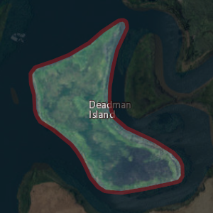
Deadman Island is an island near Suisun Bay. It is part of Solano County, California, and not managed by any reclamation district. Its coordinates are 38°13′14″N122°01′41″W, and the United States Geological Survey measured its elevation as 7 ft (2.1 m) in 1981. It is labeled, along with Joice Island, Grizzly Island, Simmons Island, Ryer Island and Roe Island, on a 1902 USGS map of the area.
Spinner Island is an island in Suisun Bay, an embayment of San Francisco Bay, downstream of the Sacramento–San Joaquin River Delta. It is part of Solano County, California, and not managed by any reclamation district. Its coordinates are 38°04′11″N121°52′10″W, and the United States Geological Survey measured its elevation as 0 ft (0 m) in 1981. It is shown in an 1850 survey map of the San Francisco Bay area made by Cadwalader Ringgold, as well as an 1854 map of the area by Henry Lange.

The Moore Tract is an island in the Sacramento–San Joaquin River Delta. It is in Solano County, California, and administered by Reclamation District 2098 since 1963. Its coordinates are 38°19′00″N121°42′53″W, and the United States Geological Survey gave its elevation as 7 ft (2.1 m) in 1981.
