
.

The Yuna River is the second longest river in the Dominican Republic at 185.17 km in length. It forms within the Cordillera Central mountain range southwest of the city of Bonao and passes through the fertile Cibao Valley. The river from there turns north-northeast passing the city of Bonao along the way. Southwest of Cotuí, the river reaches Hatillo Dam before turning northeast then east as it reaches its mouth at the Samaná Bay in the northeast part of the Dominican Republic. Like many rivers in the Dominican Republic, the name is derived from the Taíno language.

Bing Maps is a web mapping service provided as a part of Microsoft's Bing suite of search engines and powered by the Bing Maps for Enterprise framework.

The Camú River is 141.83 km (88.13 mi) long river located in the northern Dominican Republic. It rises in Cordillera Central, flowing first north and then east past the city of Concepción de la Vega before reaching its mouth at the Yuna River near the city of Pimentel at the Duarte and Sánchez Ramírez province line.

Bing is a web search engine owned and operated by Microsoft. The service has its origins in Microsoft's previous search engines: MSN Search, Windows Live Search and later Live Search. Bing provides a variety of search services, including web, video, image and map search products. It is developed using ASP.NET.
In the field of road transport, a turnaround is a type of junction that allows traffic traveling in one direction on a road to efficiently make a U-turn typically without backing up or making dangerous maneuvers in the middle of the traffic stream. While many junction types permit U-turns, the term turnaround often applies to road junctions built specifically for this purpose.

Cauquenes, a city and commune in Chile, is the capital of the Cauquenes Province and is located in the Maule Region.

Gods Lake is a lake in northeastern Manitoba in Canada. The lake covers an area of 1,151 square kilometres (444 sq mi), making it the 7th largest lake in the province. It lies north of Island Lake at an elevation of 178 metres (584 ft), approximately 280 kilometres (174 mi) east of Thompson, Manitoba. It has a shore length of 474 kilometres (295 mi). It drains north through Gods River into the Hayes River.

Conewago Creek is an 80.2-mile-long (129.1 km) tributary of the Susquehanna River in Adams and York counties in Pennsylvania in the United States, with its watershed also draining a small portion of Carroll County, Maryland. The source is at an elevation of 1,440 feet (440 m), east of Caledonia State Park, in Franklin Township in Adams County. The mouth is the confluence with the Susquehanna River at York Haven in York County at an elevation of 259 feet (79 m).

Mbandaka Airport is an airport serving the Congo River port of Mbandaka, capital city of the Équateur District in the Democratic Republic of the Congo. The runway is on the southeast side of the city.

Caimanera is a municipality and town in Guantánamo Province on the south eastern coast of Cuba. It is a fishing village and port built on the West shore of the sheltered Guantanamo Bay, just north of the US naval base and south of the provincial capital, Guantánamo.
Los Valdecolmenas is a municipality located in the province of Cuenca, Castile-La Mancha, Spain. According to the 2004 census (INE), the municipality has a population of 111 inhabitants.
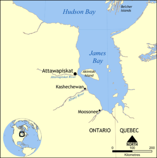
The Attawapiskat River is a river in Kenora District in northwestern Ontario, Canada, that flows east from Attawapiskat Lake to James Bay.

Machuelo Abajo is one of the 31 barrios of the municipality of Ponce, Puerto Rico. Along with Canas Urbano, Magueyes Urbano, Portugués Urbano, and San Antón, Machuelo Abajo is one of the municipality's five originally rural barrios that are now also part of the urban zone of the city of Ponce. It was created in 1831.

Jayaco River is a 14.58 km (9.06 mi) long river in the Dominican Republic province of Monseñor Nouel. A part of the Yuna River watershed, the river originates in Hoyo Redonda within the Cordillera Central mountain range. The river flows east from its source and reaches its mouth at the Rincón Reservoir, a part of the Jima River.

Carneros Creek is a south by southeastward flowing stream originating in the southernmost Mayacamas Mountains, in Napa County, California. It is the southernmost tributary to the Napa River, entering 2.5 miles (4.0 km) north of San Pablo Bay and 5 miles (8.0 km) south of the town of Napa.
El Tuqui Airport, is an airport serving Ovalle, a city in the Coquimbo Region of Chile.

The Ebrón River is a river of Spain, is a affluent of the Turia River. It sources near Tormón, in the province of Teruel (Aragon). It appears in the comarca of the Rincón de Ademuz, province of Valencia. It crosses the municipalities of Castielfabib and Torrebaja, and it mouths in the Turia River, near the limits of the municipality of Ademuz. The Ebrón River, with the Bohílges River, is the main affluent of the Turia River in the comarca of the Rincón de Ademuz.


