
The Colorado River is an 862-mile (1,387 km) long river in the U.S. state of Texas. It is the 18th longest river in the United States and the longest river with both its source and its mouth within Texas.

The White River is a 722-mile (1,162 km) long river that flows through the U.S. states of Arkansas and Missouri. Originating in the Boston Mountains of northwest Arkansas, it flows northwards into southern Missouri, and then turns back into Arkansas, flowing southeast to its mouth at the Mississippi River.

The Youngs River is a tributary of the Columbia River, approximately 27 miles (43 km) long, in northwest Oregon in the United States. It drains part of the Northern Oregon Coast Range in the extreme northwest corner of state, entering the Columbia via Youngs Bay just approximately 10 miles (16 km) from its mouth.

The John Day River is a tributary of the Columbia River, approximately 6 miles (10 km) long, in northwestern Oregon in the United States. The river rises in the Northern Oregon Coast Range in Clatsop County at 46.138889°N 123.704722°W.

The Klickitat River is a tributary of the Columbia River, nearly 96 miles (154 km) long, in south-central Washington in the United States. It drains a rugged plateau area on the eastern side of the Cascade Range northeast of Portland, Oregon. In 1986, 10 miles (16 km) of the river were designated Wild and Scenic from the confluence with Wheeler Creek, near the town of Pitt, to the confluence with the Columbia River.

The Yuna River is the second longest river in the Dominican Republic at 185.17 km in length. It forms within the Cordillera Central mountain range southwest of the city of Bonao and passes through the fertile Cibao Valley. The river from there turns north-northeast passing the city of Bonao along the way. Southwest of Cotuí, the river reaches Hatillo Dam before turning northeast then east as it reaches its mouth at the Samaná Bay in the northeast part of the Dominican Republic. Like many rivers in the Dominican Republic, the name is derived from the Taíno language.

The Camú River is 141.83 km (88.13 mi) long river located in the northern Dominican Republic. It rises in Cordillera Central, flowing first north and then east past the city of Concepción de la Vega before reaching its mouth at the Yuna River near the city of Pimentel at the Duarte and Sánchez Ramírez province line.

Conewago Creek is an 80.2-mile-long (129.1 km) tributary of the Susquehanna River in Adams and York counties in Pennsylvania in the United States, with its watershed also draining a small portion of Carroll County, Maryland. The source is at an elevation of 1,440 feet (440 m), east of Caledonia State Park, in Franklin Township in Adams County. The mouth is the confluence with the Susquehanna River at York Haven in York County at an elevation of 259 feet (79 m).
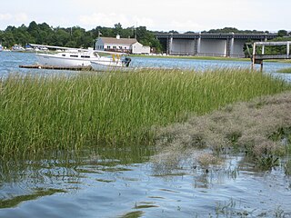
The Weymouth Back River, sometimes called Back River, is a short, primarily tidal river in Hingham and Weymouth, Massachusetts, about 10 miles (16 km) south of Boston. It arises from a number of tributaries in ponds and swamps, most notably Whitmans Pond, flows northward, and empties into Hingham Bay.
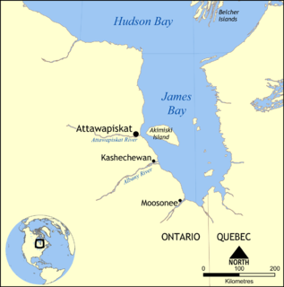
The Attawapiskat River is a river in Kenora District in northwestern Ontario, Canada, that flows east from Attawapiskat Lake to James Bay.
The Redstone River is a large river in the Northwest Territories of Canada. It is about 289 kilometres (180 mi) long. It is a tributary of the Mackenzie River, joining it on the left bank some 100 kilometres (62 mi) north of Wrigley. Draining a rugged and high area of the Mackenzie Mountains, the Redstone watershed is sparsely populated by people but remains an ecological haven for wildlife including moose, caribou, wolves Dall's Sheep and Bears. It is a pristine mountain wilderness.

The Redstone River is a river in the James Bay drainage basin in Cochrane, Timiskaming and Sudbury Districts in northeastern Ontario, Canada. It flows 87 kilometres (54 mi) from Semple Lake to its mouth at Night Hawk Lake, the source of the Frederick House River.
Stephens Creek, a 2-mile (3 km) tributary of the Willamette River, flows entirely within the city of Portland in the U.S. state of Oregon. Beginning in the neighborhood of Hillsdale, it runs generally east through residential and commercial neighborhoods as well as patches of forest and parkland to join the Willamette slightly north of the Sellwood Bridge. Its course passes under Interstate 5 and down the canyon followed by Southwest Taylors Ferry Road. Stephens Creek enters the river at Willamette Moorage Park, which is part of a 35-acre (14 ha) group of natural areas called the South Portland Riverbank. The natural areas include Butterfly Park and Willamette Park as well as the moorage park and other public land parcels.

The Snahapish River is a river in the U.S. state of Washington. It is a tributary of the Clearwater River, which in turn flows into the Queets River.
The Gilbert River is a tributary of the Multnomah Channel on Sauvie Island in the U.S. state of Oregon. About 14 miles (23 km) long, it flows from near the south end of the island into Sturgeon Lake and then north from the lake into the channel, a distributary of the Willamette River.
The Jima River is a 33.73 km (20.96 mi) long river in central Dominican Republic. The Rincón Reservoir lies along the river. The river originates in Las Neblinas, Bonao, Monseñor Nouel Province and reaches its mouth at the Camú River in Jima Abajo, La Vega Province.
Union Flat Creek is a 72-mile (120 km) long tributary of the Palouse River. Beginning at an elevation of 2,820 feet (859.5 m) near Genesee in northern Nez Perce County, Idaho, it flows west into Whitman County, Washington, passing through the towns of Uniontown and Colton. It then flows to its mouth west of La Crosse, at an elevation of 1,168 feet (356.0 m).

Battle Creek is a 67-mile (110 km) long tributary of the Owyhee River. Beginning at an elevation of 6,704 feet (2,043 m) in central Owyhee County, Idaho, it flows generally south through the Owyhee Desert to its mouth west of Riddle, at an elevation of 4,636 feet (1,413 m). In 2009, 23.4 miles (37.7 km) of the creek were designated as wild by the Omnibus Public Land Management Act, which also created the Owyhee River Wilderness.

Indian Creek is a 66-mile (106 km) long tributary of the Boise River in the U.S. state of Idaho. Beginning at an elevation of 5,047 feet (1,538 m) south of Arrowrock Reservoir in western Elmore County, it flows west into Ada County and through the town of Kuna. It then flows northwest into Canyon County, through Nampa, and finally to its mouth in Caldwell, at an elevation of 2,349 feet (716.0 m). Indian Creek has a 295-square-mile (764 km2) watershed.

The Laurel Fork is a 15.7-mile-long (25.3 km) stream in Virginia and West Virginia, United States. The stream flows north from Highland County, Virginia, where its source and the majority of its length is located, to its mouth in Pendleton County, West Virginia. Laurel Fork is a tributary to the North Fork South Branch Potomac River, making it a part of the Potomac River watershed. The area surrounding Laurel Fork is home to several plant and animal species found nowhere else in Virginia, and is a prime example of a northern boreal forest in the state.


