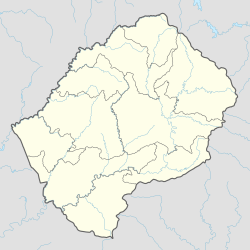
Butha-Buthe is a district of Lesotho. Butha-Buthe is the capital or camptown, and only town in the district. In the north, Butha-Buthe borders on the Free State Province of South Africa. Domestically, it borders on Mokhotlong District in southeast and Leribe District on the south.
Butha-Buthe is the capital or camptown of the Butha-Buthe District in Lesotho. It has a population of 35,108. It is named for Butha-Buthe Mountain to the north of the town. It name means "place of deposits."

Mokhotlong district is a district of Lesotho. It includes the highest terrain in the Maloti Mountains and the source of the Senqu River, Lesotho's primary watershed. Mokhotlong is the capital or camptown, and only town in the district. Mokhotlong borders on the KwaZulu-Natal Province of South Africa, with its north point bordering the Free State Province. Domestically, it borders on Butha-Buthe District in northwest, Leribe District in west, and Thaba-Tseka District in the south.
Leribè is a district of Lesotho. It has an area of 2,828 km2 and a population in 2016 of approximately 337,500. Hlotse is the capital or camptown of the district. The district has one additional town, namely Maputsoe. In the west, Leribe borders on the Free State Province of South Africa. Domestically, it borders Butha-Buthe District in the north, Mokhotlong District in the east, Thaba-Tseka District in southeast and Berea District in southwest.
Mokhotlong is a constituency, city and seat of Mokhotlong District in the mountainous northeastern part of Lesotho. It is the first major city with an airport along the road from South Africa across the Sani Pass, near the Maloti Mountains. The name of the city is a word in Sesotho, the language of the people of Lesotho, meaning "Place of the Bald Ibis." Thabana Ntlenyana, the highest point in southern Africa, is found in Mokhotlong.

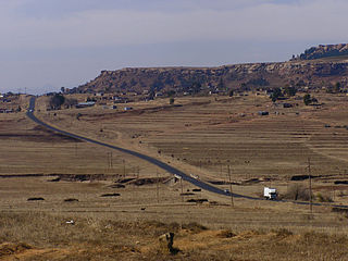
The Maloti Mountains are a mountain range of the highlands of the Kingdom of Lesotho. They extend for about 100 km into the South African Free State. The Maloti Range is part of the Drakensberg system that includes ranges across large areas of South Africa. "Maloti" is also the plural for Loti, the currency of the Kingdom of Lesotho. The range forms the northern portion of the boundary between the Butha-Buthe District in Lesotho and South Africa's Free State.
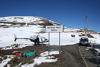
The Moteng pass is a steep tarred pass in the Maloti mountains of Lesotho, reaching a height of 2,820 m (9,250 ft). It is one of two passes that links the town of Butha-Buthe with the diamond mining town of Mokhotlong, the other pass being the Mahlasela pass. Heavy snowfall frequently closes the pass in winter. The pass is 7.9 km long, with the last stage being extremely dangerous in winter due to patches of ice.

The Mahlasela pass is a tarred pass in the Maloti mountains of Lesotho, reaching a height of 3222 meters. It is one of two passes that links the town of Butha-Buthe with the diamond mining town of Mokhotlong, the other pass being the Moteng pass. Heavy snowfalls frequently closes the pass in winter. The only skiing resort in Lesotho, Afriski is situated here. It is considered to be the highest road pass in Southern Africa.

Lesotho is a predominantly Christian country, with Islam being a minority religion. Due to secular nature of the Lesotho's constitution, Muslims are free to proselytize and build places of worship in the country. The Muslim population of Lesotho in 2013 is about 3000 plus throughout the country. Most of the population are from South Asia. South Asian Muslims, being a more prominent and established community, settled in the country to conduct business and trade. Their presence has been well noted since the early 1900s, when a few families migrated from Durban, Kwazulu-Natal. There are various mosques and prayer halls in Lesotho at the Capital City Maseru to Butha-Buthe and other places around geography of Lesotho. Jamaat Khana at Jackpot Market, Bus Stop Jamaat Khana, Pioneer Mall Jamaat Khan, Sekamaneng Islamic Centre Jamaat Khana, Osaman Masjid at Ha-Hoohlo Jamaat Khana and Thabong are the places where people offer their Friday Prayer in Maseru City. The vast majority of Muslims are Sunni. The Ahmadiyya Muslim community claims 350 members in the country and the Shi'ites Muslim are there around 1500.
Lesotho requires its residents to register their motor vehicles and display vehicle registration plates.
The LiphofungHistorical Site includes a cave which occupies an important place in Lesotho history. It is the smallest of the Lesotho Highlands Development Authority (LHDA) reserves, at about 4.5 ha, but has been intensively developed. The cave is a large overhang in the Clarens sandstone, which is a typical feature of the Lesotho lowlands region. Originally used by the San people and other Neolithic people, the walls contain important rock art and a rich archaeological deposit of Stone Age implements lies beneath the floor. Later, King Moshoeshoe the Great used the cave as a stopover when visiting that part of the kingdom.

Administratively, Lesotho is divided into ten districts, each headed by a district administrator. Each district has a capital known as a camptown.
Kao, Lesotho is a community council located in the Butha-Buthe District of Lesotho. Its population in 2006 was 5,304.
Likila is a community council located in the Butha-Buthe District of Lesotho. Its population in 2006 was 19,340.
Liqhobong is a community council located in the Butha-Buthe District of Lesotho. Its population in 2006 was 5,524.
Sekhobe is a community council located in the Butha-Buthe District of Lesotho. Its population in 2006 was 3,874.
Maliba Lodge is located within the Ts'ehlanyane National Park which is Lesotho's Largest National Park and is in the Maloti Mountains in Butha-Buthe District.
The 2016–17 Lesotho Premier League is the 49th season of top-tier football in Lesotho. The season began on 27 August 2016 and concluded on 6 May 2017. Bantu won their second league title and will represent the Lesotho Premier League in the 2018 CAF Champions League.
Butha-Buthe Warriors is a Lesotho football club based in the town of Butha-Buthe.