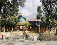
Dharamshala is a town in the Indian state of Himachal Pradesh. It serves as the winter capital of the state and the administrative headquarters of the Kangra district since 1855. The town also hosts the Tibetan Government-in-exile. Dharamshala was a municipal council until 2015, when it was upgraded to a municipal corporation.
The Mountain railways of India are the railway lines that were built in the mountainous regions of India. The term mainly includes the narrow-gauge and metre-gauge railways in these regions but may also include some broad-gauge railways.

Pathankot is a city and the district headquarters of the Pathankot district in Punjab, India. Pathankot is the 6th most populous city of Punjab, after Ludhiana, Amritsar, Jalandhar, Patiala and Bathinda. Its local government is a municipal corporation.
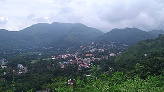
Palampur is a hill station and a municipal corporation situated in the Kangra District in the Indian state of Himachal Pradesh.
Nurpur is a city and a municipal council in Kangra district in the Indian state of Himachal Pradesh. It was formerly part of the Nurpur State since the 11th century AD. The capital of the state was at Pathankot formerly known as Paithan, now in Punjab.It got its name from wife of Mughal emperor Jahangir, Nur Jahan, when they visited Kangra (Nagarkot) after Jahangir's successful conquest of the Kangra Fort.
Sundar Nagar is a town and a municipal council in Mandi district in the Indian state of Himachal Pradesh. It was formerly a princely state, known as Suket.
Jogindernagar, or Jogindar Nagar, is a municipality, and a sub district in Mandi district in the Indian state of Himachal Pradesh. Named after Raja Joginder Sen, the hill station is the terminus of the 163-kilometre-long (101 mi) Kangra Valley narrow-gauge railway. Jogindernagar is the third-largest city in the Mandi district. The only city in Asia with three hydro-electric power stations, its nickname is "The City of Powerhouses".
Himachal Pradesh, although railways and airways serve very limited transport needs, the road network of the state serves the transport needs of the people. Although, the geography of Himachal presents considerable challenge to the development of transport infrastructure, it has the highest road density among all the Hill States of India. Himachal also has 3 airports, 2 narrow gauge rail tracks and couple of other under-construction broad gauge railway tracks, but roads remain the main mode of transport.

Shanan Power House is situated 2 km from Jogindernagar in Himachal Pradesh, India. It is the first hydroelectric power project of India in megawatt capacity. British Engineer Colonel B.C. Batty and his team in collaboration with the then ruler of Joginder Nagar region, Raja Karan Sen, designed and created it. The Shanan Power house is currently under the control of Punjab State Electricity Board and whole of the revenue goes to Punjab government. It is to be handed over to the Himachal Pradesh Government in 2024 after the completion of a 99-year lease.
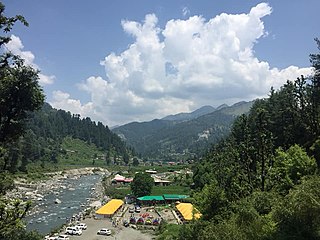
Barot, a village originally developed in the 1920s for Shanan Hydel Project, is now a tourist location in Mandi district in the Indian state of Himachal Pradesh. Barot was difficult to access until 1975, when a road was opened. It is situated 40 km from Jogindernagar and 65 km from Mandi, the district headquarter. The road to Barot branches off at Jogindernagar-Mandi Highway and from Jogindernagar the distance is 40 km. It is sometimes possible to use the funicular trolley from Jogindernagar which reduces the distance to 12 km. The road route includes terraced fields and thick cedar forests, rising to Jhatingri at the hilltop. The remains of the summer palace of the former rulers of Mandi are located here. Through the small village of Tikkan, the road carries on to Barot. The town has a range of outdoor activities, including a trout breeding centre, from where fish are released into the Uhl river. A 30 km section of the river is used for angling.

The Kangra Valley Railway is a 2 ft 6 in gauge railway that runs from Pathankot, Punjab to Jogindernagar in Himachal Pradesh. It runs through the sub-Himalayan region of Kangra Valley and is 164 km (101.9 mi) long. It is on the UNESCO World Heritage Sites tentative list. The railway is part of the Firozpur division of Northern Railway. It is the longest Narrow Gauge line in India and also the longest 2 ft 6 in Gauge Railway in the World. The highest point on this line is Ahju station at an elevation of 1,290 meters (4,230 ft). There are 33 stops and 950 bridges.
The Lokmanya Nagar railway station, is one of the local railway stations in Indore City.
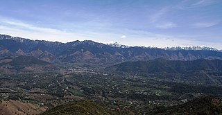
Joginder Nagar Valley is a valley in the Indian state of Himachal Pradesh. The valley contains the town of Joginder Nagar, Bir-Billing, Chauntra and various other hill resorts surrounded by mountains on all sides. The valley falls in the mid-hill zone of the Dhauladhar mountain range in the foothills of the Indian Himalayas. Geographically, the valley starts near Ghatta at its westernmost point and stretches south-eastwards up to Ghatasani, 15 kilometres from the main town. On an average, the valley is stretched 20 kilometres in length and 10 kilometers in width.
Jawali is a town in Kangra District of Himachal Pradesh State in India.Old name of Jawali is Jawanwalashehar. Jawali is the second largest Assembly constituency in the state of Himachal Pradesh. It is located 250 km distance from its State Capital, Shimla and is located 50 km distance from its District headquarters Dharamshala.

The Bhanupli–Leh line is an under-construction electrified railway track connecting Bhanupli, Punjab, to Leh, Ladakh. Once complete, the 489 km (304 mi) long, 1,676 mm wide gauge all-weather track is stipulated to reduce travel time from New Delhi to Leh to 10 hours. The railway is to pass through seismic zone IV and V at an elevation of 600 m (2,000 ft) to 5,360 m (17,590 ft) above sea level.
Himachal Road Transport Corporation, also referred to as HRTC, is the state-owned road transport corporation of the state of Himachal Pradesh, India. HRTC provides bus services to towns and cities within Himachal Pradesh and the adjoining and nearby states of Uttarakhand, Punjab, Haryana, Delhi, Uttar Pradesh, Jammu and Kashmir and Rajasthan. HRTC is one of the first RTC's in India to offer a facility for online booking of tickets for all types of buses.
Jawalamukhi Road railway station is a small railway station in Kangra district in the Indian state of Himachal Pradesh. The station lies on Pathankot–Jogindernagar narrow-gauge railway. This railway is also called Kangra Valley Railway. Jawalamukhi Road railway station is located at an altitude of 549 metres (1,801 ft) above mean sea level. It was allotted the railway code of JMKR under the jurisdiction of Firozpur railway division. This line was planned in 1926 and commissioned in 1929.
Palampur Himachal Railway Station is a small railway station in Kangra district in the Indian state of Himachal Pradesh. The station lies on Kangra Valley Railway. Palampur Himachal railway station is at an elevation of 1,119 metres (3,671 ft). It was allotted the railway code of PLMX under the jurisdiction of Firozpur railway division. The 610 mm -wide narrow gauge was opened for traffic in 1929. In 1929 the line was regauged to 762 mm -wide narrow gauge.
Ichhi is a village and a Village Panchayat in Kangra district in the Indian state of Himachal Pradesh. Ichhi village is 8 kilometres from Kangra.
Kangra railway station is a main railway station in Kangra district in the Indian state of Himachal Pradesh. The station lies on UNESCO World Heritage Site Kangra Valley Railway. It is located at an altitude of 674 metres (2,211 ft) above mean sea level. It was allotted the railway code of KGRA under the jurisdiction of Firozpur railway division. The 610 mm -wide narrow gauge was opened for traffic in 1929. In 1929 the line was regauged to 762 mm -wide narrow gauge.