
Sierra Leone, officially the Republic of Sierra Leone, is a country on the southwest coast of West Africa. It shares its southeastern border with Liberia, and the northern half of the nation is surrounded by Guinea. Covering a total area of 71,740 km2 (27,699 sq mi), Sierra Leone has a tropical climate, with diverse environments ranging from savanna to rainforests. The country has a population of 7,092,113 as of the 2015 census. Freetown is the capital and largest city. The country is divided into five administrative regions, which are subdivided into 16 districts.
Sierra Leone first became inhabited by indigenous African peoples at least 2,500 years ago. The Limba were the first tribe known to inhabit Sierra Leone. The dense tropical rainforest partially isolated the region from other West African cultures, and it became a refuge for peoples escaping violence and jihads. Sierra Leone was named by Portuguese explorer Pedro de Sintra, who mapped the region in 1462. The Freetown estuary provided a good natural harbour for ships to shelter and replenish drinking water, and gained more international attention as coastal and trans-Atlantic trade supplanted trans-Saharan trade.

Sierra Leone is a country in West Africa with a North Atlantic Ocean coastline to the west. It lies on the African Plate. The country's main geographical features include wooded hill country, an upland plateau, and mountains in the east. The highest peak is Mount Bintumani, which is 1,948 meters (6,391 ft) above sea level. The coastline has a belt of mangrove swamps. Freetown, the nation's capital city, has one of the world's largest natural harbours. The Rokel River is the largest river in Sierra Leone. It is 400 kilometres (250 mi) long and has a basin with a total area of 10,622 square kilometres (4,101 sq mi).
The economy of Sierra Leone is $4.082 billion by gross domestic product as of 2018. Since the end of the Sierra Leone Civil War in 2002, the economy is gradually recovering with a gross domestic product growth rate between 4 and 7%. In 2008 it in PPP ranked between 147th by World Bank, and 153rd by CIA, largest in the world.

There are a number of systems of transport in Sierra Leone, a country in West Africa, which possess road, rail, air and water infrastructure, including a network of highways and several airports.

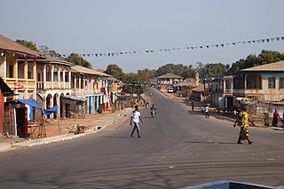
Freetown is the capital and largest city of Sierra Leone. It is a major port city on the Atlantic Ocean and is located in the Western Area of the country. Freetown is Sierra Leone's major urban, economic, financial, cultural, educational and political centre, as it is the seat of the Government of Sierra Leone. The population of Freetown was 1,055,964 at the 2015 census.

Sierra Leone is divided into four provinces and one Western Area; these are further divided into 16 districts, and the districts are further divided into 190 chiefdoms.

Sherbro Island is in the Atlantic Ocean, and is included within Bonthe District, Southern Province, Sierra Leone. The island is separated from the African mainland by the Sherbro River in the north and Sherbro Strait in the east. It is 32 miles (51 km) long and up to 15 miles (24 km) wide, covering an area of approximately 230 square miles (600 km2). The western extremity is Cape St. Ann. Bonthe, on the eastern end, is the chief port and commercial centre.

The Mano River is a river in West Africa. It originates in the Guinea Highlands in Liberia and forms part of the Liberia-Sierra Leone border.

The Southern Province is one of the four provinces of Sierra Leone. It covers an area of 19,694 km² and has a population of 1,438,572. It consists of four districts. Its capital and administrative center is Bo, which is also the second largest and second most populated city in Sierra Leone after the nation's capital Freetown. The population of the southern province is largely from the Mende ethnic group.
Magburaka is the capital and largest city of Tonkolili District in the Northern Province of Sierra Leone. Its population was 16,313 in the 2004 census. and a current estimate of 40,313. It is located at around 8°43′1″N11°56′36″W, along the Rokel River. Magburaka lies just about 26 miles (42 km) drive south-west of Makeni, the economic center of Northern Sierra Leone and about 80 miles (135 km) drive east of the country's capital Freetown. Magburaka is a trade center and is one of the main cities in Northern Sierra Leone. As with most parts of Sierra Leone, the Krio language of the Sierra Leone Creole people is the most widely spoken language in Magburaka.

The Upper Guinean forests is a tropical seasonal forest region of West Africa. The Upper Guinean forests extend from Guinea and Sierra Leone in the west through Liberia, Côte d'Ivoire and Ghana to Togo in the east, and a few hundred kilometers inland from the Atlantic coast. A few enclaves of montane forest lie further inland in the mountains of central Guinea and central Togo and Benin.
The Temne, also called Atemne, Témené, Temné, Téminè, Temeni, Thaimne, Themne, Thimni, Timené, Timné, Timmani, or Timni, are a West African ethnic group, They are predominantly found in the Northern Province of Sierra Leone. Some Temne are also found in Guinea. The Temne constitute the largest ethnic group in Sierra Leone, at 35.5% of the total population, which is slightly bigger than the Mende people at 31.2%. They speak Temne, a Mel branch of the Niger–Congo languages.
Railway stations in Sierra Leone include:

The Guinea Highlands is a densely forested mountainous plateau extending from central Guinea through northern Sierra Leone and Liberia to western Ivory Coast. The highlands include a number of mountains, ranges and plateaus, including the Fouta Djallon highlands in central Guinea, the Loma Mountains in Sierra Leone, the Simandou and Kourandou massifs in southeastern Guinea, the Nimba Range at the border of Guinea, Liberia, and Ivory Coast, and the Monts du Toura in western Ivory Coast.
Mattru Jong commonly known as Mattru is the capital of Bonthe District in the Southern Province of Sierra Leone. Mattru Jung is located on the mainland of Bonthe District, along the Jong River, 52 miles southwest of Bo. The town is the seat of Mongerewa Jong Chiefdom, and is the home of Mongerewa Jong Paramount Chief Alie Badara Sheriff III. The town's current estimated population is about 20,000 people. In 2010 it was 8,199, and in the 2004 census the town had a population of 7,647.

There are 84 kilometres of railway in Sierra Leone, all of which is private and of a narrow gauge, 1,067 mm.

The Bankasoka River is a river in Sierra Leone.
The Gallinas people is a name applied to an ethnic group in eastern Sierra Leone, which formerly existed as an independent kingdom.
