The Amazon River in South America is the largest river by discharge volume of water in the world, and the longest or second-longest river system in the world, a title which is disputed with the Nile.

The country of Brazil occupies roughly half of South America, bordering the Atlantic Ocean. Brazil covers a total area of 8,514,215 km2 (3,287,357 sq mi) which includes 8,456,510 km2 (3,265,080 sq mi) of land and 55,455 km2 (21,411 sq mi) of water. The highest point in Brazil is Pico da Neblina at 2,994 m (9,823 ft). Brazil is bordered by the countries of Argentina, Bolivia, Colombia, Guyana, Paraguay, Peru, Suriname, Uruguay, Venezuela, and French Guiana.

Amazonas is a state of Brazil, located in the North Region in the north-western corner of the country. It is the largest Brazilian state by area and the ninth-largest country subdivision in the world. It is the largest country subdivision in South America, being greater than the areas of Chile, Paraguay, and Uruguay combined. Neighbouring states are Roraima, Pará, Mato Grosso, Rondônia, and Acre. It also borders the nations of Peru, Colombia and Venezuela. This includes the Departments of Amazonas, Vaupés and Guainía in Colombia, as well as the Amazonas state in Venezuela, and the Loreto Region in Peru.

The Jaú National Park is a national park located in the state of Amazonas, Brazil. It is one of the largest forest reserves in South America, and part of a World Heritage Site.

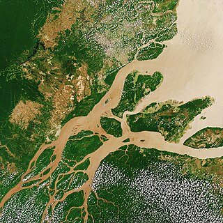
The Japurá River or Caquetá River is a 2,820 kilometres (1,750 mi) long river in the Amazon basin. It rises in Colombia and flows eastward through Brazil to join the Amazon River.

The Putumayo River or Içá River is one of the tributaries of the Amazon River, southwest of and parallel to the Japurá River.

Japurá is a municipality located in the Brazilian state of Amazonas. Its population was 2,251 (2020) and its area is 55,791 km² (21541 Mi2). It forms the Japurá microregion together with the municipality Maraã (to the east of the Japurá municipality). The southern border of both the municipality and the microregion is the Japurá River.
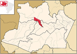
Maraã is a municipality located in the Brazilian state of Amazonas. Its population was 18,261 (2020) and its area is 16,910 km². Together with the municipality Japurá it forms the microregion Japurá.

Amazonía region in southern Colombia comprises the departments of Amazonas, Caquetá, Guainía, Guaviare, Putumayo and Vaupés, and covers an area of 483,000 km2, 35% of Colombia's total territory. The region is mostly covered by tropical rainforest, or jungle, which is a part of the greater Amazon rainforest.

Physopyxis is a genus of thorny catfishes native to tropical South America.
Juami-Japurá Ecological Station is an ecological station in the municipality of Japurá, Amazonas, Brazil.
The Mamirauá Sustainable Development Reserve in the Brazilian state of Amazonas, near the city of Tefé, is a 4,300-square-mile (11,000 km2) reserve near the village of Boca do Mamirauá. It includes mostly Amazonian flooded forest and wetlands. The ribeirinhos are native to the area.
The Auati-Paraná Canal is a natural canal of Amazonas state in north-western Brazil. It is a distributary that leaves the Solimões River and joins the Japurá River.
The Taraira River (Traíra) is a river forms part of the boundary of Colombia and Brazil. It is part of the Amazon River basin.

The Amazon biome contains the Amazon rainforest, an area of tropical rainforest, and other ecoregions that cover most of the Amazon basin and some adjacent areas to the north and east. The biome contains blackwater and whitewater flooded forest, lowland and montane terra firma forest, bamboo and palm forest, savanna, sandy heath and alpine tundra. Some areas of the biome are threatened by deforestation for timber and to make way for pasture or soybean plantations.
Amanã Sustainable Development Reserve is a sustainable development reserve in the state of Amazonas, Brazil.

The Central Amazon Ecological Corridor is an ecological corridor in the state of Amazonas, Brazil, that connects a number of conservation units in the Amazon rainforest. The objective is to maintain genetic connectivity between the protected areas without penalizing the local people, where possible using participatory planning that involves all affected actors.

The Negro–Branco moist forests (NT0143) is an ecoregion of tropical moist broadleaf forest to the east of the Andes in southern Venezuela, eastern Colombia and northern Brazil, in the Amazon biome. It lies on the watershed between the Orinoco and Rio Negro basins. It includes both blackwater and whitewater rivers, creating different types of seasonally flooded forest. The vegetation is more typical of the Guiana region than the Amazon.

The Japurá–Solimões–Negro moist forests (NT0132) is an ecoregion of tropical moist broad leaf forest in the Amazon biome.
