
A dam is a barrier that stops or restricts the flow of surface water or underground streams. Reservoirs created by dams not only suppress floods but also provide water for activities such as irrigation, human consumption, industrial use, aquaculture, and navigability. Hydropower is often used in conjunction with dams to generate electricity. A dam can also be used to collect or store water which can be evenly distributed between locations. Dams generally serve the primary purpose of retaining water, while other structures such as floodgates or levees are used to manage or prevent water flow into specific land regions. The earliest known dam is the Jawa Dam in Jordan, dating to 3,000 BC.

The Osage River is a 276-mile-long (444 km) tributary of the Missouri River in central Missouri in the United States. The eighth-largest river in the state, it drains a mostly rural area of 15,300 square miles (40,000 km2). The watershed includes an area of east-central Kansas and a large portion of west-central and central Missouri, where it drains northwest areas of the Ozark Plateau.
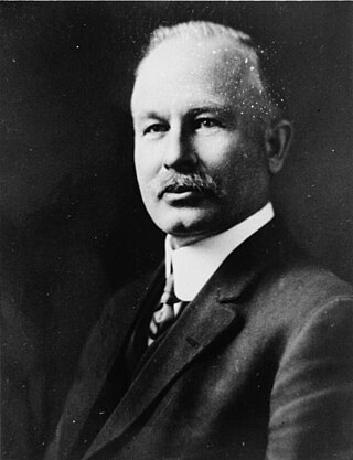
John Samuel Eastwood was an American engineer who built the world's first reinforced concrete multiple-arch dam on bedrock foundation at Hume Lake, California, in 1908, and was one of California's pioneers of hydroelectric power production. Eastwood's papers are held at the Water Resources Collections and Archives, University of California, Riverside.

The Fort Peck Dam is the highest of six major dams along the Missouri River, located in northeast Montana in the United States, near Glasgow, and adjacent to the community of Fort Peck. At 21,026 feet (6,409 m) in length and over 250 feet (76 m) in height, it is the largest hydraulically filled dam in the United States, and creates Fort Peck Lake, the fifth largest artificial lake in the U.S., more than 130 miles (210 km) long, 200 feet (61 m) deep, and it has a 1,520-mile (2,450 km) shoreline which is longer than the state of California's coastline. It lies within the Charles M. Russell National Wildlife Refuge. The dam and the 134-mile-long (216 km) lake are owned and operated by the U.S. Army Corps of Engineers and exist for the purposes of hydroelectric power generation, flood control, and water quality management.

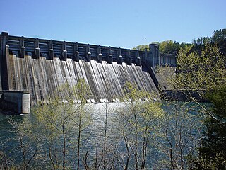
Bagnell Dam impounds the Osage River in the U.S. state of Missouri, creating the Lake of the Ozarks. The dam is located in the city of Lakeside in Miller County, near the Camden-Miller County line. The 148-foot (45 m) tall concrete gravity dam was built by the Union Electric Company to generate hydroelectric power at its Osage Powerplant. It is 2,543 feet (775 m) long, including a 520-foot (160 m) long spillway and a 511-foot (156 m) long power station. The facility with eight generators has a maximum capacity of 215 megawatts. The dam provides power to 42,000 homes.

Lake of the Ozarks is a reservoir created by impounding the Osage River in the northern part of the Ozarks in central Missouri. Parts of three smaller tributaries to the Osage are included in the impoundment - the Niangua River, Grandglaize Creek, and Gravois Creek. The lake has a surface area of 54,000 acres (220 km2) and 1,150 miles (1,850 km) of shoreline. The main channel of the Osage Arm stretches 92 miles (148 km) from one end to the other. The total drainage area is over 14,000 square miles (36,000 km2). The lake's serpentine shape has earned it the nickname "the Missouri Dragon", which has, in turn, inspired the names of local institutions such as the Magic Dragon Street Meet.

Center Hill Lake is a reservoir in the U.S. state of Tennessee. It is located in Middle Tennessee near Smithville. Created by means of a dam constructed by the U.S. Army Corps of Engineers in 1948, the lake has a dual purpose: electricity production and flood control. Center Hill Dam is 260 ft (79 m) high, and it is composed of concrete and earth structures, with 8 gates that are 50 ft (15 m) wide each. Center Hill Lake is one of four major flood control reservoirs for the Cumberland; the others being Percy Priest Lake, Dale Hollow Reservoir, and Lake Cumberland.
Norfork Dam is a large dam in northern Arkansas southeast of Mountain Home. It dams North Fork River and creates Norfork Lake. The top of the dam supports a 2-lane roadway, part of AR 177.

Gavins Point Dam is a 1.9 mi (3 km) long embankment rolled-earth and chalk-fill dam which spans the Missouri River and impounds Lewis and Clark Lake. The dam joins Cedar County, Nebraska with Yankton County, South Dakota a distance of 811.1 river miles (1,305 km) upstream of St. Louis, Missouri, where the river joins the Mississippi River. The dam and hydroelectric power plant were constructed as the Gavins Point Project from 1952 to 1957 by the United States Army Corps of Engineers as part of the Pick-Sloan Plan. The dam is located approximately 4 miles (6.4 km) west or upstream of Yankton, South Dakota.

The New Waddell Dam is an embankment dam on the Agua Fria River in Maricopa County, Arizona, 35 miles (56 km) northwest of Phoenix. It serves as part of the Central Arizona Project (CAP) while also providing water for the Maricopa Water District. The dam creates Lake Pleasant with water from the Agua Fria and also the CAP aqueduct. In addition, it affords flood protection, hydroelectric power production and recreational opportunities. Construction on the dam began in 1985 and ended in 1994. Its reservoir submerged the Old Waddell Dam which was completed in 1927 after decades of planning.

Mark Twain Lake is a reservoir located in Ralls and Monroe Counties in the U.S. state of Missouri. It was created by the Clarence Cannon Dam impounding the Salt River and is located about 20 miles (32 km) southwest of Hannibal. The lake was named for Missouri author Mark Twain and part of the area around it is Mark Twain State Park. The village of Florida, the birthplace of Mark Twain, is mostly surrounded by the lake.

Summersville Lake is a reservoir located in the US state of West Virginia. The lake is formed by a rock-fill dam on the Gauley River, south of Summersville in Nicholas County. It is the largest lake in West Virginia, with 2,700 acres (1,100 ha) of water and over 60 miles (97 km) of shoreline at the summer pool water level. Its maximum depth is 327 feet.

Croton Dam is an earth-filled embankment dam and powerplant complex on the Muskegon River in Croton Township, Newaygo County, Michigan. It was built in 1907 under the direction of William D. Fargo by the Grand Rapids - Muskegon Power Company, a predecessor of Consumers Energy. The 40-foot-high (12 m) dam impounds 7.2 billion U.S. gallons (6 billion imp. gal/27 billion L) of water in its 1,209-acre (489 ha) reservoir and is capable of producing 8,850 kilowatts at peak outflow. It was listed on the National Register of Historic Places in 1979.

Mosul Dam, formerly known as Saddam Dam, is the largest dam in Iraq. It is located on the Tigris river in the western governorate of Nineveh, upstream of the city of Mosul. The dam serves to generate hydroelectricity and provide water for downstream irrigation. At full capacity, the structure holds about 11.1 cubic kilometres (2.7 cu mi) of water and provides electricity to the 1.7 million residents of Mosul.

Hardy Dam is an earth-filled embankment dam and powerplant complex on the Muskegon River in Big Prairie Township, Newaygo County, Michigan. At the time of its completion, it was the largest earthen dam in North America east of the Mississippi. Its impoundment forms a lake with over 50 miles of shoreline. The dam impounds a reservoir with a surface area of 4,000 acres and its power plant has an installed capacity of 31.5 MW.

Caliraya Dam is an embankment dam located in the town of Lumban province of Laguna, in the Sierra Madre Mountain Range of the Philippines. The reservoir created by the dam, Lake Caliraya, initially supplied one of the oldest hydroelectric plants in the Philippines, and later became a popular recreational area for numerous water sports and fishing. The dam's construction was started in 1939 under the supervision of the architecture firm of Pedro Siochi and Company and a small hydroelectric plant was operated in 1942.

Holter Dam is a hydroelectric straight gravity dam on the Missouri River about 45 miles (72 km) northeast of Helena, Montana, in the United States. The dam, which was built between 1908 and 1918, is 1,364 feet (416 m) long and 124 feet (38 m) high. The reservoir formed by the dam, Holter Lake is 25 miles (40 km) long and has a storage capacity of 243,000 acre-feet (300,000,000 m3) of water when full. The dam is a "run-of-the-river" dam because it can generate electricity without needing to store additional water supplies behind the dam.

Hauser Dam is a hydroelectric straight gravity dam on the Missouri River about 14 miles (23 km) northeast of Helena, Montana, in the United States. The original dam, built between 1905 and 1907, failed in 1908 and caused severe flooding and damage downstream. A second dam was built on the site in 1908 and opened in 1911 and comprises the present structure. The current Hauser Dam is 700 feet (210 m) long and 80 feet (24 m) high. The reservoir formed by the dam, Hauser Lake, is 25 miles (40 km) long, has a surface area of 3,800 acres (1,500 ha), and has a storage capacity of 98,000 acre-feet (121,000,000 m3) of water when full.
The Irkutsk Hydroelectric Power Station is a rock-fill dam on the Angara River with an adjacent hydroelectric power station. It is located adjacent to Irkutsk, Irkutsk Oblast in Russia and is the first dam on the Angara cascades. Construction on the dam began in 1950, its reservoir began filling in 1956 and its first turbines were also commissioned in 1956. It was the first large hydroelectric power station constructed in Eastern Siberia and its completion was hailed by the Soviets as an engineering success.

The Big Creek Hydroelectric Project is an extensive hydroelectric power scheme on the upper San Joaquin River system, in the Sierra Nevada of central California. The project is owned and operated by Southern California Edison (SCE). The use and reuse of the waters of the San Joaquin River, its South Fork, and the namesake of the project, Big Creek – over a vertical drop of 6,200 ft (1,900 m) – have over the years inspired a nickname, "The Hardest Working Water in the World".