
The Kimberley is the northernmost of the nine regions of Western Australia. It is bordered on the west by the Indian Ocean, on the north by the Timor Sea, on the south by the Great Sandy and Tanami deserts in the region of the Pilbara, and on the east by the Northern Territory.

The Buccaneer Archipelago is a group of islands off the coast of Western Australia near the town of Derby in the Kimberley region. The closest inhabited place is Bardi located about 54 kilometres (34 mi) from the western end of the island group.

The Wunaamin Miliwundi Ranges are a range of hills in the western Kimberley region of Western Australia.

The Shire of Wyndham East Kimberley is one of the four local government areas in the Kimberley region of northern Western Australia, covering an area of 117,514 square kilometres (45,372 sq mi) at Western Australia's northeastern corner. The Shire's seat of government was originally in Wyndham but now in the town of Kununurra, which is home to over half of the Shire's permanent population of around 7,000, while a council office is located at Wyndham.
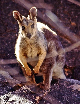
The black-flanked rock-wallaby, also known as the black-footed rock-wallaby or warru, is a species of wallaby, one of several rock-wallabies in the genus Petrogale. A shy, nocturnal herbivore, its two main subspecies are found in mostly isolated populations across western and southern Western Australia (WA), the Northern Territory and parts of South Australia (SA). With some subspecies showing a decline in populations in recent years, the whole species is classed as an endangered species under the Commonwealth EPBC Act.
Western Australia has the longest coastline of any state or territory in Australia, at 10,194 km or 12,889 km. It is a significant portion of the coastline of Australia, which is 35,877 km.

The 1995–96 Australian region cyclone season was an active Australian cyclone season, with Western Australia experiencing a record number of landfalling intense storms in the Pilbara region. The season produced a total of 19 tropical cyclones, of which 14 developed into named storms and 9 reached severe tropical cyclone status. The strongest of the season was Severe Tropical Cyclone Olivia, which also produced the highest recorded wind gust on record of 408 km/h (253 mph). Though several systems impacted land, the general sparsity of population centres in Australia limits the scale of damage. One person was confirmed to have been killed and cumulative losses were estimated at A$77 million (US$58.5 million).

Camden Sound is a relatively wide body of water in the Indian Ocean located in the Kimberley region of Western Australia. The Sound is bounded by the Bonaparte Archipelago to the north-east, the Buccaneer Archipelago to the south-west, and Montgomery Reef to the south.
George Alan Solem, known professionally as Alan Solem, was an American malacologist, a biologist who studied mollusks.
The Sale River is a river in the Kimberley region of Western Australia. The river was seen and named on 9 June 1865 by an expedition from the short-lived Camden Harbor settlement searching for pastoral land. The expedition comprised Alexander McRae, Trevarton Sholl, PC William Gee, John Stainer and an Aboriginal constable named Billy.

Yawajaba Island, often referred to as Montgomery Island, is an island off the Kimberley coast of Western Australia.
The Islands of the Kimberley are a group of over 2,500 islands lying off the coast of the Kimberley region of Western Australia. The islands extend from the Western Australia–Northern Territory border in the east to just north of Broome in the west.
Liveringa or Liveringa Station, often referred to as Upper Liveringa Station, is a pastoral lease in Western Australia that once operated as a sheep station but presently operates as a cattle station.

Browse Island is a small, approximately 14-hectare (35-acre), uninhabited island lying in the Timor Sea about 180 kilometres (110 mi) north-west of the Kimberley coast of north-western Australia. It is a Western Australian Nature Reserve that is classed as 'Not Class A' vested with the state Conservation Commission and managed by the Department of Environment and Conservation. It is considered Western Australia's most remote island, and is also one of the most remote Australian islands to not fall under external territory status.
Kimberley Downs Station, commonly referred to as Kimberley Downs, is a pastoral lease that operates as a cattle station in Western Australia.
Boongaree Island is located off the Kimberley coast of Western Australia.
Coronation Island, also known as Garlinju, is located off the Kimberley coast of Western Australia. It encompasses an area of 3,817 hectares. It is located off Port Nelson in the Bonaparte Archipelago, as a part of the group of islands known as the Coronation Islands, which were named by Philip Parker King, the first European to visit the islands in 1820, after the anniversary of the coronation of George III, who had died in January of that year.
Uwins Island is located off the Kimberley coast of Western Australia.
Champagny Island, known to the traditional owners as Nimenba, is an island off the coast of the Kimberley region in Western Australia.
The following is a list of all reported tropical cyclones within the Australian region between 90°E and 160°E in the 1960s. During the decade, tropical cyclones were named by the New Caledonia Meteorological Service, while the Australian Bureau of Meteorology started to name them during the 1963–64 season.
