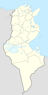
Remada is a town in Tunisia, close to the border with Libya. It is located at around 32°18′22″N10°22′56″E. Remada was built as a garrison town by the French and is today home to a Tunisian military base.

The Deutsches Theater in Berlin is a well-known German theatre. It was built in 1850 as Friedrich-Wilhelm-Städtisches Theater, after Frederick William IV of Prussia. Located on Schumann Street (Schumannstraße), the Deutsches Theater consists of two adjoining stages that share a common, classical facade. The main stage was built in 1850, originally for operettas.

Komorówko is a village in the administrative district of Gmina Trzebnica, within Trzebnica County, Lower Silesian Voivodeship, in south-western Poland. Prior to 1945 it was in Germany.
Dąbrówka is a village in the administrative district of Gmina Bytoń, within Radziejów County, Kuyavian-Pomeranian Voivodeship, in north-central Poland.
Bogołomia-Kolonia is a village in the administrative district of Gmina Chodecz, within Włocławek County, Kuyavian-Pomeranian Voivodeship, in north-central Poland.

Leniszki is a village in the administrative district of Gmina Czarnożyły, within Wieluń County, Łódź Voivodeship, in central Poland. It lies approximately 3 kilometres (2 mi) north of Czarnożyły, 10 km (6 mi) north of Wieluń, and 83 km (52 mi) south-west of the regional capital Łódź.

Stanisławów Pierwszy is a village in the administrative district of Gmina Nieporęt, within Legionowo County, Masovian Voivodeship, in east-central Poland. It lies approximately 5 kilometres (3 mi) south of Nieporęt, 9 km (6 mi) east of Legionowo, and 19 km (12 mi) north of Warsaw.

Jaczewek is a village in the administrative district of Gmina Dobre, within Mińsk County, Masovian Voivodeship, in east-central Poland.
Kolonia Stary Ratyniec is a village in the administrative district of Gmina Sterdyń, within Sokołów County, Masovian Voivodeship, in east-central Poland.
Bagrianwala is a town and union council of Gujrat District, in the Punjab province of Pakistan. It is part of Kharian Tehsil and is located at 32°33'0N 73°52'0E with an altitude of 217 metres.

Imiołki is a village in the administrative district of Gmina Kiszkowo, within Gniezno County, Greater Poland Voivodeship, in west-central Poland. It lies approximately 10 kilometres (6 mi) east of Kiszkowo, 16 km (10 mi) west of Gniezno, and 37 km (23 mi) north-east of the regional capital Poznań. On January 1, 2013 a portion of the village became a new village called Pola Lednickie.

Sarnowa is a village in the administrative district of Gmina Ślesin, within Konin County, Greater Poland Voivodeship, in west-central Poland. It lies approximately 3 kilometres (2 mi) north-west of Ślesin, 19 km (12 mi) north of Konin, and 93 km (58 mi) east of the regional capital Poznań.

Trzebin is a village in the administrative district of Gmina Dobrzyca, within Pleszew County, Greater Poland Voivodeship, in west-central Poland. It lies approximately 4 kilometres (2 mi) west of Dobrzyca, 17 km (11 mi) west of Pleszew, and 74 km (46 mi) south-east of the regional capital Poznań.
Borownik is a village in the administrative district of Gmina Obrzycko, within Szamotuły County, Greater Poland Voivodeship, in west-central Poland.
Sułów is a village in the administrative district of Gmina Rzepin, within Słubice County, Lubusz Voivodeship, in western Poland.

Krzewiaki is a village in the administrative district of Gmina Walce, within Krapkowice County, Opole Voivodeship, in south-western Poland. It lies approximately 2 kilometres (1 mi) north-east of Walce, 11 km (7 mi) south-east of Krapkowice, and 33 km (21 mi) south of the regional capital Opole.

Solec is a village in the administrative district of Gmina Biała, within Prudnik County, Opole Voivodeship, in south-western Poland. It lies approximately 5 kilometres (3 mi) south-east of Biała Prudnicka, 13 km (8 mi) north-east of Prudnik, and 35 km (22 mi) south-west of the regional capital Opole.

Dobra is a village in the administrative district of Gmina Dębnica Kaszubska, within Słupsk County, Pomeranian Voivodeship, in northern Poland. It lies approximately 14 kilometres (9 mi) east of Dębnica Kaszubska, 24 km (15 mi) south-east of Słupsk, and 83 km (52 mi) west of the regional capital Gdańsk.

The Waalse kerk is a historical church dating from the 14th century on the Begijnhof in Haarlem, Netherlands.

Qiaoxiang station is a Metro station of Shenzhen Metro Line 2. It opened on 28 June 2011. It is located nearby the Qiaoxiang Road.


