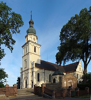
Pszczew is a village in Międzyrzecz County, Lubusz Voivodeship, in western Poland. It is the seat of the gmina called Gmina Pszczew. It lies approximately 13 kilometres (8 mi) east of Międzyrzecz, 46 km (29 mi) south-east of Gorzów Wielkopolski, and 62 km (39 mi) north of Zielona Góra.

Brzozowy Ług is a village in the administrative district of Gmina Międzyrzecz, within Międzyrzecz County, Lubusz Voivodeship, in western Poland. It lies approximately 5 kilometres (3 mi) north of Międzyrzecz, 35 km (22 mi) south-east of Gorzów Wielkopolski, and 61 km (38 mi) north of Zielona Góra.
Gorzyca is a village in the administrative district of Gmina Międzyrzecz, within Międzyrzecz County, Lubusz Voivodeship, in western Poland. It lies approximately 8 kilometres (5 mi) west of Międzyrzecz, 36 km (22 mi) south-east of Gorzów Wielkopolski, and 57 km (35 mi) north of Zielona Góra.

Kaława is a village in the administrative district of Gmina Międzyrzecz, within Międzyrzecz County, Lubusz Voivodeship, in western Poland.
Kalsko is a village in the administrative district of Gmina Międzyrzecz, within Międzyrzecz County, Lubusz Voivodeship, in western Poland. It lies approximately 8 kilometres (5 mi) north of Międzyrzecz, 36 km (22 mi) south-east of Gorzów Wielkopolski, and 64 km (40 mi) north of Zielona Góra.
Kęszyca is a village in the administrative district of Gmina Międzyrzecz, within Międzyrzecz County, Lubusz Voivodeship, in western Poland. It lies approximately 7 kilometres (4 mi) south-west of Międzyrzecz, 40 km (25 mi) south-east of Gorzów Wielkopolski, and 53 km (33 mi) north of Zielona Góra.
Kuligowo is a village in the administrative district of Gmina Międzyrzecz, within Międzyrzecz County, Lubusz Voivodeship, in western Poland. It lies approximately 5 kilometres (3 mi) north-east of Międzyrzecz, 41 km (25 mi) south-east of Gorzów Wielkopolski, and 60 km (37 mi) north of Zielona Góra.
Kursko is a village in the administrative district of Gmina Międzyrzecz, within Międzyrzecz County, Lubusz Voivodeship, in western Poland. It lies approximately 11 kilometres (7 mi) west of Międzyrzecz, 36 km (22 mi) south of Gorzów Wielkopolski, and 55 km (34 mi) north of Zielona Góra.
Kwiecie is a village in the administrative district of Gmina Międzyrzecz, within Międzyrzecz County, Lubusz Voivodeship, in western Poland.
Nietoperek is a village in the administrative district of Gmina Międzyrzecz, within Międzyrzecz County, Lubusz Voivodeship, in western Poland. It lies approximately 7 kilometres (4 mi) south of Międzyrzecz, 42 km (26 mi) south of Gorzów Wielkopolski, and 52 km (32 mi) north of Zielona Góra.
Pniewo is a settlement in the administrative district of Gmina Międzyrzecz, within Międzyrzecz County, Lubusz Voivodeship, in western Poland. It lies approximately 11 kilometres (7 mi) south-west of Międzyrzecz, 44 km (27 mi) south-east of Gorzów Wielkopolski, and 48 km (30 mi) north of Zielona Góra.
Wysoka is a village in the administrative district of Gmina Międzyrzecz, within Międzyrzecz County, Lubusz Voivodeship, in western Poland. It lies approximately 14 kilometres (9 mi) south-west of Międzyrzecz, 43 km (27 mi) south of Gorzów Wielkopolski, and 48 km (30 mi) north of Zielona Góra.
Goruńsko is a village in the administrative district of Gmina Bledzew, within Międzyrzecz County, Lubusz Voivodeship, in western Poland. It lies approximately 4 kilometres (2 mi) south of Bledzew, 14 km (9 mi) west of Międzyrzecz, 30 km (19 mi) south of Gorzów Wielkopolski, and 61 km (38 mi) north of Zielona Góra.
Strużyny is a settlement in the administrative district of Gmina Bledzew, within Międzyrzecz County, Lubusz Voivodeship, in western Poland. It lies approximately 3 kilometres (2 mi) south-west of Bledzew, 17 km (11 mi) west of Międzyrzecz, 28 km (17 mi) south of Gorzów Wielkopolski, and 63 km (39 mi) north of Zielona Góra.
Silna is a village in the administrative district of Gmina Pszczew, within Międzyrzecz County, Lubusz Voivodeship, in western Poland. It lies approximately 6 kilometres (4 mi) east of Pszczew, 18 km (11 mi) east of Międzyrzecz, 51 km (32 mi) south-east of Gorzów Wielkopolski, and 64 km (40 mi) north of Zielona Góra.
Dobrojewo is a village in the administrative district of Gmina Skwierzyna, within Międzyrzecz County, Lubusz Voivodeship, in western Poland. It lies approximately 10 kilometres (6 mi) north of Skwierzyna, 28 km (17 mi) north of Międzyrzecz, and 16 km (10 mi) east of Gorzów Wielkopolski.
Kijewice is a village in the administrative district of Gmina Skwierzyna, within Międzyrzecz County, Lubusz Voivodeship, in western Poland. It lies approximately 5 kilometres (3 mi) west of Skwierzyna, 22 km (14 mi) north-west of Międzyrzecz, and 18 km (11 mi) south-east of Gorzów Wielkopolski.
Rybojady is a village in the administrative district of Gmina Trzciel, within Międzyrzecz County, Lubusz Voivodeship, in western Poland. It lies approximately 6 kilometres (4 mi) north-west of Trzciel, 18 km (11 mi) east of Międzyrzecz, 55 km (34 mi) south-east of Gorzów Wielkopolski, and 56 km (35 mi) north-east of Zielona Góra.


