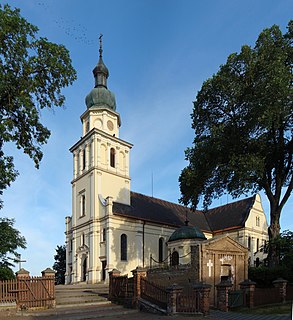
Pszczew is a village in Międzyrzecz County, Lubusz Voivodeship, in western Poland. It is the seat of the gmina called Gmina Pszczew. It lies approximately 13 kilometres (8 mi) east of Międzyrzecz, 46 km (29 mi) south-east of Gorzów Wielkopolski, and 62 km (39 mi) north of Zielona Góra.

Brzozowy Ług is a village in the administrative district of Gmina Międzyrzecz, within Międzyrzecz County, Lubusz Voivodeship, in western Poland. It lies approximately 5 kilometres (3 mi) north of Międzyrzecz, 35 km (22 mi) south-east of Gorzów Wielkopolski, and 61 km (38 mi) north of Zielona Góra.
Bukowiec is a village in the administrative district of Gmina Międzyrzecz, within Międzyrzecz County, Lubusz Voivodeship, in western Poland. It lies approximately 14 kilometres (9 mi) north-east of Międzyrzecz, 37 km (23 mi) south-east of Gorzów Wielkopolski, and 69 km (43 mi) north of Zielona Góra.
Głębokie is a village in the administrative district of Gmina Międzyrzecz, within Międzyrzecz County, Lubusz Voivodeship, in western Poland. It lies approximately 6 kilometres (4 mi) north-west of Międzyrzecz, 34 km (21 mi) south-east of Gorzów Wielkopolski, and 61 km (38 mi) north of Zielona Góra.
Kalsko is a village in the administrative district of Gmina Międzyrzecz, within Międzyrzecz County, Lubusz Voivodeship, in western Poland. It lies approximately 8 kilometres (5 mi) north of Międzyrzecz, 36 km (22 mi) south-east of Gorzów Wielkopolski, and 64 km (40 mi) north of Zielona Góra.
Karolewo is a village in the administrative district of Gmina Międzyrzecz, within Międzyrzecz County, Lubusz Voivodeship, in western Poland. It lies approximately 7 kilometres (4 mi) east of Międzyrzecz, 45 km (28 mi) south-east of Gorzów Wielkopolski, and 56 km (35 mi) north of Zielona Góra.
Kęszyca Leśna is a village in the administrative district of Gmina Międzyrzecz, within Międzyrzecz County, Lubusz Voivodeship, in western Poland. It lies approximately 11 kilometres (7 mi) south-west of Międzyrzecz, 5 km (3 mi) west of Nietoperek, just west of Kęszyca, close to the Krzewie Lake. It was a location of the Soviet military garrison, which left in 1993, and since 1994 it is an independent populated place.
Kolonia Nietoperek is a village in the administrative district of Gmina Międzyrzecz, within Międzyrzecz County, Lubusz Voivodeship, in western Poland. It lies approximately 8 kilometres (5 mi) south-west of Międzyrzecz, 44 km (27 mi) south-east of Gorzów Wielkopolski, and 50 km (31 mi) north of Zielona Góra.
Kolonia Żółwin is a village in the administrative district of Gmina Międzyrzecz, within Międzyrzecz County, Lubusz Voivodeship, in western Poland. It lies approximately 5 kilometres (3 mi) north-east of Międzyrzecz, 38 km (24 mi) south-east of Gorzów Wielkopolski, and 61 km (38 mi) north of Zielona Góra.
Kuźnik is a village in the administrative district of Gmina Międzyrzecz, within Międzyrzecz County, Lubusz Voivodeship, in western Poland. It lies approximately 5 kilometres (3 mi) south-east of Międzyrzecz, 44 km (27 mi) south-east of Gorzów Wielkopolski, and 54 km (34 mi) north of Zielona Góra.
Marianowo is a settlement in the administrative district of Gmina Międzyrzecz, within Międzyrzecz County, Lubusz Voivodeship, in western Poland. It lies approximately 7 kilometres (4 mi) north-east of Międzyrzecz, 41 km (25 mi) south-east of Gorzów Wielkopolski, and 61 km (38 mi) north of Zielona Góra.
Międzyrzecz-Wybudowanie is a village in the administrative district of Gmina Międzyrzecz, within Międzyrzecz County, Lubusz Voivodeship, in western Poland. It lies approximately 3 kilometres (2 mi) south-east of Międzyrzecz, 39 km (24 mi) south-east of Gorzów Wielkopolski, and 56 km (35 mi) north-east of Zielona Góra.
Rojewo is a village in the administrative district of Gmina Międzyrzecz, within Międzyrzecz County, Lubusz Voivodeship, in western Poland. It lies approximately 9 kilometres (6 mi) north of Międzyrzecz, 32 km (20 mi) south-east of Gorzów Wielkopolski, and 65 km (40 mi) north of Zielona Góra.
Skoki is a village in the administrative district of Gmina Międzyrzecz, within Międzyrzecz County, Lubusz Voivodeship, in western Poland. It lies approximately 5 kilometres (3 mi) south-east of Międzyrzecz, 44 km (27 mi) south-east of Gorzów Wielkopolski, and 54 km (34 mi) north of Zielona Góra.
Święty Wojciech is a village in the administrative district of Gmina Międzyrzecz, within Międzyrzecz County, Lubusz Voivodeship, in western Poland. It lies approximately 4 kilometres (2 mi) south-west of Międzyrzecz, 39 km (24 mi) south-east of Gorzów Wielkopolski, and 55 km (34 mi) north of Zielona Góra.
Wyszanowo is a village in the administrative district of Gmina Międzyrzecz, within Międzyrzecz County, Lubusz Voivodeship, in western Poland. It lies approximately 9 kilometres (6 mi) south-east of Międzyrzecz, 48 km (30 mi) south-east of Gorzów Wielkopolski, and 51 km (32 mi) north of Zielona Góra.
Żółwin is a village in the administrative district of Gmina Międzyrzecz, within Międzyrzecz County, Lubusz Voivodeship, in western Poland. It lies approximately 4 kilometres (2 mi) east of Międzyrzecz, 41 km (25 mi) south-east of Gorzów Wielkopolski, and 58 km (36 mi) north of Zielona Góra.
Rokitno is a village in the administrative district of Gmina Przytoczna, within Międzyrzecz County, Lubusz Voivodeship, in western Poland. It lies approximately 3 kilometres (2 mi) south-west of Przytoczna, 13 km (8 mi) north of Międzyrzecz, 34 km (21 mi) south-east of Gorzów Wielkopolski, and 69 km (43 mi) north of Zielona Góra.
Silna is a village in the administrative district of Gmina Pszczew, within Międzyrzecz County, Lubusz Voivodeship, in western Poland. It lies approximately 6 kilometres (4 mi) east of Pszczew, 18 km (11 mi) east of Międzyrzecz, 51 km (32 mi) south-east of Gorzów Wielkopolski, and 64 km (40 mi) north of Zielona Góra.
Dobrojewo is a village in the administrative district of Gmina Skwierzyna, within Międzyrzecz County, Lubusz Voivodeship, in western Poland. It lies approximately 10 kilometres (6 mi) north of Skwierzyna, 28 km (17 mi) north of Międzyrzecz, and 16 km (10 mi) east of Gorzów Wielkopolski.


