
Castle Square is the plaza at the intersection of High Street, Angel Street, and Arundel Gate in the City of Sheffield, England. This name was given to the square in the 1960s to reflect the proximity of the square to the site of Sheffield Castle, which was formerly located a short distance to the north-east.
Liu To is the area around the valley in the midwest of Tsing Yi Island. There is a stream in the valley watering the narrow band of agricultural fields of Liu To Village (寮肚村). Its water formerly filled the Tsing Yi Lagoon and nurtured the rice paddies around the lagoon but now is just water flowing in the underground nullah to the Rambler Channel. The valley has occasionally been referred to as the Liu To Valley (寮肚谷) and the surrounding hills as Liu To Hill (寮肚山).

Anzoátegui is a town and municipality in the Tolima Department of Colombia. The population of the municipality was 9,700 as of the 1993 census.
Na Zahradkach Stadion is a multi-use stadium in Rimavská Sobota, Slovakia. It is used mostly for football matches and is the home ground of FC Rimavská Sobota. The stadium holds 5,000 people.
Hijiyama-bashi is a Hiroden station on Hiroden Hijiyama Line, located in Hijiyama-hon-machi, Minami-ku, Hiroshima.

Wildwood is a hamlet in west-central Alberta, Canada within Yellowhead County. It is located on the Yellowhead Highway, approximately 112 kilometres (70 mi) west of Edmonton and 82 kilometres (51 mi) east of Edson. The Yellowhead Highway's intersection with Cowboy Trail is 9 kilometres (5.6 mi) east of the hamlet. The Lobstick River, which flows from Chip Lake to the west, runs through the hamlet.
Madre de Dios District is one of four districts of Manú Province in Peru.
Czarnopole is a village in the administrative district of Gmina Góra Świętej Małgorzaty, within Łęczyca County, Łódź Voivodeship, in central Poland.
Litwinki is a village in the administrative district of Gmina Nidzica, within Nidzica County, Warmian-Masurian Voivodeship, in northern Poland.
The West Branch Piscataquis River is a 22-mile-long (35 km) tributary of the Piscataquis River in Piscataquis County, Maine. Its source is in East Moxie, Somerset County . The river runs about 6 miles (10 km) east, then 11 miles (18 km) south, then 5 miles (8 km) east to its confluence with the East Branch Piscataquis River in Blanchard to form the Piscataquis.
Kulak is a village in the District of Şuhut, Afyonkarahisar Province, Turkey.
Boztahta is a village in the District of Karaisalı, Adana Province, Turkey.

Samidorphan, also known as 3-carboxamido-4-hydroxynaltrexone, is an opioid antagonist that preferentially acts as an antagonist of the μ-opioid receptor (MOR). It is under development by Alkermes for the treatment of major depressive disorder and possibly other psychiatric conditions.
Dereköy is a village in the District of Korkuteli, Antalya Province, Turkey.
Aşağıovacık is a village in the District of Gerede, Bolu Province, Turkey. As of 2010, it had a population of 50 people.
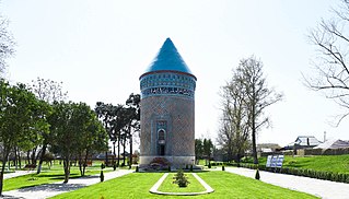
Barda Mausoleum – is located in Barda, Azerbaijan. It is one of the rear monuments which reached us safely. It is located in a small square-shaped territory surrounded with a cob wall.
Sarmiyeh is a Syrian village located in Jubb Ramlah Subdistrict in Masyaf District, Hama. According to the Syria Central Bureau of Statistics (CBS), Sarmiyeh had a population of 2953 in the 2004 census.
Valle de Agua Arriba is a corregimiento in Changuinola District, Bocas del Toro Province, Panama. It has a land area of 70.3 square kilometres (27.1 sq mi) and had a population of 3,163 as of 2010, giving it a population density of 45 inhabitants per square kilometre (120/sq mi). It was created by Law 18 of February 26, 2009.
Santo Tomás is a corregimiento in Alanje District, Chiriquí Province, Panama. It has a land area of 45.1 square kilometres (17.4 sq mi) and had a population of 1,259 as of 2010, giving it a population density of 27.9 inhabitants per square kilometre (72/sq mi). Its population as of 1990 was 721; its population as of 2000 was 840.
Krewinkel is a hamlet in the municipality of Büllingen, in the province of Liège, Belgium. It has 84 inhabitants and lies at an altitude of about 560 meters. Until 1919 it was owned by Germany.


