Kaaimans River

Last updated

Kaaimans River
Kaaimansrivier
Tide's coming in.jpg
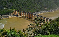
Tide coming up the estuary of the Kaaimans River
Kaaimans River
South Africa relief location map.svg
Red pog.svg
Location of the Kaaimans River mouth
EtymologyNamed kaaiman after leguaan, a species of Monitor Lizard which was formerly found in the river. [1]
Nickname(s)Keeromrivier
Location
Country South Africa
Province Western Cape
Region Garden Route
Physical characteristics
SourceN of George
  location Outeniqua Mountains
Mouth Indian Ocean
  location
W of Wilderness, Western Cape
  coordinates
33°59′52″S22°33′25″E / 33.99778°S 22.55694°E / -33.99778; 22.55694
  elevation
0 m (0 ft)

The Kaaimans River (Afrikaans : Kaaimansrivier), also known as Keerom River, is a river in the Western Cape, South Africa. The mouth of the river lies near Wilderness. [2] Further upriver, the Kaaimans River Gorge is popular for hiking and whitewater kayaking. [3]

Contents

The nearest large towns are Mossel Bay and George.

History

Ox-wagon crossing the Kaaimans River in the late 19th century Saasveld04.jpg
Ox-wagon crossing the Kaaimans River in the late 19th century

The Kaaimans River was formerly an obstacle for travellers, whose wagons had to wait sometimes for weeks before being able to cross it safely when it ran full of water. It was also nicknamed "Keeromrivier" (Turnabout River) because, faced with the raging waters, some travellers had to turn and try to find another way to reach their destination. Finally this obstacle was overcome when the Seven Passes Road was built by Thomas Charles John Bain. [4]

The tidal estuary at its mouth is crossed by a rail bridge. The Outeniqua Choo Tjoe, the last passenger steam train in Africa, crossed this bridge until the line was closed due to landslides in 2006.

See also

Related Research Articles

<span class="mw-page-title-main">Zambezi</span> Major river in southern Africa

The Zambezi is the fourth-longest river in Africa, the longest east-flowing river in Africa and the largest flowing into the Indian Ocean from Africa. Its drainage basin covers 1,390,000 km2 (540,000 sq mi), slightly less than half of the Nile's. The 2,574-kilometre-long (1,599 mi) river rises in Zambia and flows through eastern Angola, along the north-eastern border of Namibia and the northern border of Botswana, then along the border between Zambia and Zimbabwe to Mozambique, where it crosses the country to empty into the Indian Ocean.

<span class="mw-page-title-main">Victoria Falls</span> Waterfall on the Zambezi River in Zambia and Zimbabwe

Victoria Falls is a waterfall on the Zambezi River in southern Africa, which provides habitat for several unique species of plants and animals. It is located on the border between Zambia and Zimbabwe and is one of the world's largest waterfalls, with a width of 1,708 m (5,604 ft).

<span class="mw-page-title-main">Pigeon River (Minnesota–Ontario)</span> River in Minnesota and Ontario, Canada and United States

The Pigeon River forms part of the Canada–United States border between the state of Minnesota and the province of Ontario, west of Lake Superior. In pre-industrial times, the river was a waterway of great importance for transportation and the fur trade.

<span class="mw-page-title-main">Kouilou-Niari River</span> River in the Republic of the Congo

The Kouilou-Niari River—also spelled Kwilu, Kwila, or Kwil—is the most important river flowing to the Atlantic Ocean of the Republic of the Congo coast. Moreover, its entire drainage area is completely in the Republic of the Congo. The river is called the Kouilou River while flowing in the coastal region of the Kouilou till the Sounda gorges. Upstream from the gorges, its name is the Niari River and it flows through the Niari Valley. The river combines with the Louessé, the Loudima and the Bouenza River and eventually flows into the Atlantic Ocean. It covers about 560 km from its origin in the Batéké Plateau of the Congo to its mouth at the coast.

<span class="mw-page-title-main">Waimakariri River</span> River in Canterbury, New Zealand

The Waimakariri River is one of the largest rivers in Canterbury, on the eastern coast of New Zealand's South Island. It flows for 151 kilometres (94 mi) in a generally southeastward direction from the Southern Alps across the Canterbury Plains to the Pacific Ocean.

<span class="mw-page-title-main">Fraser Canyon</span> Canyon in British Columbia, Canada

The Fraser Canyon is a major landform of the Fraser River where it descends rapidly through narrow rock gorges in the Coast Mountains en route from the Interior Plateau of British Columbia to the Fraser Valley. Colloquially, the term "Fraser Canyon" is often used to include the Thompson Canyon from Lytton to Ashcroft, since they form the same highway route which most people are familiar with, although it is actually reckoned to begin above Williams Lake at Soda Creek Canyon near the town of the same name.

<span class="mw-page-title-main">Komati River</span> River in Eswatini, Mozambique

The Komati River, also known as the Inkomati River or Incomati River, is a river in South Africa, Eswatini and Mozambique. Originating in north-western Eswatini, it is joined by the Crocodile River in the Lebombo Mountains, enters far south-western Mozambique below the border town of Komatipoort, and enters the Indian Ocean around 24 km (15 mi) north-east of Maputo.

<span class="mw-page-title-main">N2 (South Africa)</span> National road in South Africa

The N2 is a national route in South Africa that runs from Cape Town through George, Gqeberha, East London, Mthatha, Port Shepstone and Durban to Ermelo. It is the main highway along the Indian Ocean coast of the country. Its current length of 2,255 kilometres (1,401 mi) makes it the longest numbered route in South Africa.

<span class="mw-page-title-main">Tsitsikamma National Park</span> Protected area on the Garden Route, Western Cape and Eastern Cape, South Africa

The Tsitsikamma National Park is a protected area on the Garden Route, Western Cape and Eastern Cape, South Africa. It is a coastal reserve well known for its indigenous forests, dramatic coastline, and the Otter Trail. On 6 March 2009 it was amalgamated with the Wilderness National Park and various other areas of land to form the Garden Route National Park.

<span class="mw-page-title-main">Muddy Creek (central Utah)</span>

Muddy Creek is a stream in central Utah, United States, that drains portions of Emery, Sanpete, Sevier, and Wayne counties.

<span class="mw-page-title-main">Virginia State Route 130</span>

Virginia State Route 130 is a primary state highway in the U.S. state of Virginia. The state highway runs 34.69 miles (55.83 km) from U.S. Route 11 at Natural Bridge east to SR 669 and SR 670 east of US 29 near Madison Heights. SR 130 runs concurrently with US 501 from Glasgow through the James River gorge through the Blue Ridge Mountains, connecting eastern Rockbridge County with western and southern Amherst County near Lynchburg.

<span class="mw-page-title-main">Wilderness, South Africa</span> Place in Western Cape, South Africa

Wilderness is a seaside town on the Garden Route of the southern Cape in South Africa. It is situated a short distance to the east from the city of George, on the N2 down the Kaaiman's River Pass.

<span class="mw-page-title-main">Lehigh Gorge State Park</span>

Lehigh Gorge State Park is a 4,548 acres (1,841 ha) Pennsylvania state park in Luzerne and Carbon Counties, Pennsylvania. The park encompasses a gorge, which stretches along the Lehigh River from a U.S. Army Corps of Engineers flood control dam in Luzerne County to Jim Thorpe in Carbon County.

<span class="mw-page-title-main">Scott's Gulf</span> Canyon in Tennessee

Scott's Gulf is a canyon situated along the Caney Fork River in White County, Tennessee, in the southeastern United States. The canyon stretches for approximately 18 miles (29 km) as the Caney Fork drops from the top of the Cumberland Plateau down to the eastern Highland Rim. This remote section of the river is home to a wilderness area consisting of a largely undisturbed deciduous forest, numerous waterfalls, caves and other geological formations, and Class IV and Class V whitewater rapids.

<span class="mw-page-title-main">Incomappleux River</span> River in British Columbia, Canada

The Incomappleux River is in the West Kootenay region of southeastern British Columbia, Canada. Entering the Beaton Arm of Upper Arrow Lake, the river is a major tributary of the Columbia River. The upper reaches of the Incomappleux valley are home to some of the only inland temperate rainforest in the world.

<span class="mw-page-title-main">Relief of Ladysmith</span>

When the Second Boer War broke out on 11 October 1899, the Boers had a numeric superiority within Southern Africa. They quickly invaded the British territory and laid siege to Ladysmith, Kimberley and Mafeking. Britain meanwhile transported thousands of troops both from the United Kingdom itself and from elsewhere in the Empire and by the time the siege of Ladysmith had been lifted, had a huge numeric superiority.

<span class="mw-page-title-main">Van Stadens River</span> River in the Eastern Cape, South Africa

Van Stadens River is a river in the Eastern Cape province of South Africa. The river mouth is located about 30 km west of Port Elizabeth.

<span class="mw-page-title-main">Kaaimans River Pass</span>

Kaaimans River Pass, is a mountain pass situated in the Western Cape Province of South Africa. It is located above the Kaaimans River on the road between George and Wilderness. The road of this pass, named the Seven Passes Road, was built by Thomas Charles John Bain and his brother-in-law, Adam de Smidt, in 1867, and was used for over one century.

<span class="mw-page-title-main">North Fork Eel River</span> River in California, United States

The North Fork Eel River is the smallest of four major tributaries of the Eel River in northwestern California in the United States. It drains a rugged wilderness area of about 286 square miles (740 km2) in the California Coast Ranges, and flows through national forests for much of its length. Very few people inhabit the relatively pristine watershed of the river; there are no operational stream gauges and only one bridge that crosses the river, near the boundary between Trinity and Mendocino Counties.

<span class="mw-page-title-main">Hokitika Gorge</span>

Hokitika Gorge and the surrounding Hokitika Gorge Scenic Reserve are a major tourist destination some 33 kilometres (21 mi) or 40 minutes drive inland from Hokitika, New Zealand. Since August 2020, a second suspension bridge over the Hokitika River at the gorge provides the opportunity for a round track.

References