Kaback

Last updated
Kaback
Sub-prefecture and town
Guinea adm location map.svg
Red pog.svg
Kaback
Location in Guinea
Coordinates: 9°24′N13°21′W / 9.400°N 13.350°W / 9.400; -13.350
CountryFlag of Guinea.svg  Guinea
Region Kindia Region
Prefecture Forécariah Prefecture
Time zone GMT (UTC+0)

Kaback is a town and sub-prefecture in the Forécariah Prefecture in the Kindia Region of western Guinea. [1]

Town settlement that is bigger than a village but smaller than a city

A town is a human settlement. Towns are generally larger than villages but smaller than cities, though the criteria to distinguish them vary considerably between different parts of the world.

Sub-prefectures of Guinea

The sub-prefectures are the third-level administrative divisions in Guinea. As of 2009 there were 303 rural sub-prefectures of Guinea and 38 urban sub-prefectures, 5 of which compose the Conakry greater urban area; Kaloum, Dixinn, Matam, Ratoma and Matoto.

Forécariah Prefecture Prefecture in Kindia Region, Guinea

Forécariah is a prefecture located in the Kindia Region of Guinea. The capital is Forécariah. The prefecture covers an area of 4,384 km2 and has a 2014 census population of 242,942.

Related Research Articles

Dabola Prefecture Prefecture in Faranah Region, Guinea

Dabola is a prefecture located in the Faranah Region of Guinea. The capital is Dabola. The prefecture covers an area of 6,350 km.² and has an estimated population of 182,951.

Dubréka Prefecture Prefecture in Kindia Region, Guinea

Dubréka is a prefecture located in the Kindia Region of Guinea. The capital is Dubréka. The prefecture covers an area of 4,350 km² and has a population of 330,548.

Douprou Sub-prefecture and town in Boké Region, Guinea

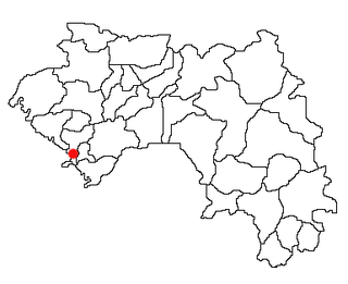
Douprou is a town and sub-prefecture in the Boffa Prefecture in the Boké Region of western Guinea. As of 2014 it had a population of 21,045 people.

Kindoyé Sub-prefecture and town in Faranah Region, Guinea

Kindoyé is a town and sub-prefecture in the Dabola Prefecture in the Faranah Region of Guinea. As of 2014 it had a population of 6,495 people.

Badi, Guinea Sub-prefecture and town in Kindia Region, Guinea

Badi, Guinea is a town and sub-prefecture in the Dubréka Prefecture in the Kindia Region of western Guinea.

Kakony Sub-prefecture and town in Boké Region, Guinea

Kakony is a town and sub-prefecture in the Gaoual Prefecture in the Boké Region of north-western Guinea. As of 2014 it had a population of 33,204 people.

Mamouroudou Sub-prefecture in Kankan Region, Guinea

Mamouroudou is a sub-prefecture in the Kankan Prefecture in the Kankan Region of eastern Guinea. As of 2014 it had a population of 14,609 people.

Gbangbadou Sub-prefecture and town in Faranah Region, Guinea

Gbangbadou is a town and sub-prefecture in the Kissidougou Prefecture in the Faranah Region of Guinea. As of 2014 it had a population of 13,861 people.

Sangardo Sub-prefecture and town in Faranah Region, Guinea

Sangardo is a town and sub-prefecture in the Kissidougou Prefecture in the Faranah Region of Guinea. As of 2014 it had a population of 21,646 people.

Kamaby Sub-prefecture and town in Boké Region, Guinea

Kamaby is a town and sub-prefecture in the Koundara Prefecture in the Boké Region of northern Guinea. As of 2014 it had a population of 16,178 people.

Saréboido Sub-prefecture and town in Boké Region, Guinea

Saréboido is a town and sub-prefecture in the Koundara Prefecture in the Boké Region of northern Guinea. As of 2014 it had a population of 33,700 people.

Kiniéro Sub-prefecture and town in Kankan Region, Guinea

Kiniéro is a town and sub-prefecture in the Kouroussa Prefecture in the Kankan Region of eastern-central Guinea. As of 2014 it had a population of 22,267 people.

Sibiribaro Sub-prefecture and town in Kankan Region, Guinea

Sibiribaro is a town and sub-prefecture in the Kérouané Prefecture in the Kankan Region of south-eastern Guinea. As of 2014 it had a population of 16,485 people.

Daralabe Sub-prefecture and town in Labé Region, Guinea

Daralabe is a town and sub-prefecture in the Labé Prefecture in the Labé Region of northern-central Guinea.

Parawol Sub-prefecture and town in Labé Region, Guinea

Parawol is a town and sub-prefecture in the Lélouma Prefecture in the Labé Region of northern-central Guinea.

Koyamah Sub-prefecture and town in Nzérékoré Region, Guinea

Koyamah is a town and sub-prefecture in the Macenta Prefecture in the Nzérékoré Region of south-eastern Guinea.

Tangali Sub-prefecture and town in Labé Region, Guinea

Tangali is a town and sub-prefecture in the Tougué Prefecture in the Labé Region of northern-central Guinea.

Koba, Kindia Sub-prefecture and town in Kindia Region, Guinea

Koba, Kindia is a town and sub-prefecture in the Télimélé Prefecture in the Kindia Region of western-central Guinea.

Hafia Sub-prefecture and town in Labé Region, Guinea

Hafia is a town and sub-prefecture in the Labé Prefecture in the Labé Region of northern-central Guinea.

Sannou Sub-prefecture and town in Labé Region, Guinea

Sannou is a town and sub-prefecture in the Labé Prefecture, located in the Labé Region of northern-central Guinea.

References

  1. "Subprefectures of Guinea". Statoids. Retrieved April 19, 2009.

Coordinates: 9°24′N13°21′W / 9.400°N 13.350°W / 9.400; -13.350

Geographic coordinate system Coordinate system

A geographic coordinate system is a coordinate system that enables every location on Earth to be specified by a set of numbers, letters or symbols. The coordinates are often chosen such that one of the numbers represents a vertical position and two or three of the numbers represent a horizontal position; alternatively, a geographic position may be expressed in a combined three-dimensional Cartesian vector. A common choice of coordinates is latitude, longitude and elevation. To specify a location on a plane requires a map projection.