
Gateway Arch National Park is an American national park located in St. Louis, Missouri, near the starting point of the Lewis and Clark Expedition.

Letchworth State Park is a 14,427-acre (5,838 ha) New York State Park located in Livingston County and Wyoming County in the western part of the State of New York. The park is roughly 17 miles (27 km) long, following the course of the Genesee River as it flows north through a deep gorge and over several large waterfalls. It is located 35 miles (56 km) southwest of Rochester and 60 miles (97 km) southeast of Buffalo, and spans portions of the Livingston County towns of Leicester, Mount Morris and Portage, as well as the Wyoming County towns of Castile and Genesee Falls.

A natural arch, natural bridge, or rock arch is a natural landform where an arch has formed with an opening underneath. Natural arches commonly form where inland cliffs, coastal cliffs, fins or stacks are subject to erosion from the sea, rivers or weathering.
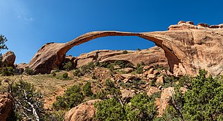
Landscape Arch is a natural arch in Arches National Park, Utah, United States. It is among the longest natural rock arches in the world.

Natural Bridges National Monument is a U.S. National Monument located about 50 miles (80 km) northwest of the Four Corners boundary of southeast Utah, in the western United States, at the junction of White Canyon and Armstrong Canyon, part of the Colorado River drainage. It features the thirteenth largest natural bridge in the world, carved from the white Permian sandstone of the Cedar Mesa Formation that gives White Canyon its name.

Rainbow Bridge is a natural arch in southern Utah, United States. With a span of 275 feet (84 m), as reported in 1974 by the Bureau of Reclamation, and height of 290 feet (88 m), it is one of the largest natural arches in the world. At the top it is 42 feet (13 m) thick and 33 feet (10 m) wide. The bridge, which is of cultural importance to a number of area Native American tribes, has been designated a Traditional Cultural Property by the National Park Service. Rainbow Bridge National Monument was protected in 1910, and it is administered by Glen Canyon National Recreation Area.

The Colorado Plateau, also known as the Colorado Plateau Province, is a physiographic and desert region of the Intermontane Plateaus, roughly centered on the Four Corners region of the southwestern United States. This province covers an area of 336,700 km2 (130,000 mi2) within western Colorado, northwestern New Mexico, southern and eastern Utah, northern Arizona, and a tiny fraction in the extreme southeast of Nevada. About 90% of the area is drained by the Colorado River and its main tributaries: the Green, San Juan, and Little Colorado. Most of the remainder of the plateau is drained by the Rio Grande and its tributaries.

Navajo Bridge is the name of twin steel spandrel arch bridges that cross the Colorado River in the Grand Canyon National Park in northern Coconino County, Arizona, United States. The newer of the two spans carries vehicular traffic on U.S. Route 89A (US 89A) over Marble Canyon between Bitter Springs and Jacob Lake, allowing travel into a remote Arizona Strip region north of the Colorado River including the North Rim of Grand Canyon National Park.

Wrather Arch is a cave type natural arch in the Paria Canyon-Vermilion Cliffs Wilderness, in Coconino County, northern Arizona. The sandstone arch is located in the eponymous Wrather Canyon, a short side canyon of Paria Canyon. The Paria River is a tributary of the Colorado River, at its confluence down−canyon at Lee's Ferry. Wrather Arch was first spotted by a local pilot from Page, Arizona, Royce K Knight, as he flew over a remote gorge west of Glen Canyon. Reaching the arch by helicopter in 1963, Knight and National Geographic staff man Walter M Edwards calculated its height as 165 feet and about 250 feet across. A news bulletin from National Geographic dated February 4, 1966 states, "Tall as a 15 story building, Wrather Arch ... The Taj Mahal would fit comfortably into the arch..."

Sipapu Bridge is a natural bridge or arch located in the Natural Bridges National Monument in central San Juan County, Utah, United States. The bridge spans White Canyon.

Hunts Mesa is a rock formation located in Monument Valley, south of the border between Utah and Arizona in the United States and west of the border between Arizona's Navajo County and Apache County. It is one of two popular interior destinations in the Monument Valley Navajo Tribal Park for tourists to experience panoramic views of the popular sandstone formations from a distance. The other is Mystery Valley. A Navajo guide is required to hike to either.

Tonto Natural Bridge is a natural arch in Arizona, United States, that is believed to be the largest natural travertine bridge in the world. The area surrounding the bridge has been made into a state park called Tonto Natural Bridge State Park, which is located off State Route 87, just 10 miles (16 km) north of Payson. Tonto Natural Bridge stands over a 400-foot-long (120 m) tunnel that measures 150 feet (46 m) at its widest point and reaches a height of 183 feet (56 m).
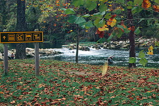
Bennett Spring State Park is a public recreation area located in Bennett Springs, Missouri, twelve miles (19 km) west of Lebanon on Highway 64 in Dallas and Laclede counties. It is centered on the spring that flows into the Niangua River and gives the park its name. The spring averages 100 million gallons of daily flow. The park offers fly fishing, camping, canoeing, hiking, and other activities.

The Casselman Bridge is a historic transportation structure on the Casselman River, located immediately east of Grantsville in Garrett County, Maryland. The bridge was built in 1813-1814 as part of the National Road. Historic markers posted at each end read:
Erected 1813 by David Shriver, Jr.,
Sup't of the "Cumberland Road". This 80 foot span
was the largest stone arch in America
at the time. It was continuously
used from 1813 to 1933.

Arches National Park is a national park in eastern Utah, United States. The park is adjacent to the Colorado River, 4 mi (6 km) north of Moab, Utah. More than 2,000 natural sandstone arches are located in the park, including the well-known Delicate Arch, as well as a variety of unique geological resources and formations. The park contains the highest density of natural arches in the world.

The Union Covered Bridge State Historic Site is a Missouri State Historic Site in Monroe County, Missouri. The covered bridge is a Burr-arch truss structure built in 1871 over the Elk Fork of the Salt River. It was almost lost to neglect in the 1960s, but was added to the state park system in 1967, the same year it was damaged by a flood. Repairs were made the next year, using timbers salvaged from another covered bridge that had been destroyed by the same flood. In 1970, it was closed to vehicular traffic and was added to the National Register of Historic Places. Further repairs were made in 1988, and it survived the Great Flood of 1993, only to be damaged by another flood in 2008 and later re-repaired. It is about 120 feet (37 m) or 125 feet (38 m) long, 12 feet (3.7 m) high, and 17.5 feet (5.3 m) wide.

Strawberry Crater is a cinder cone volcano, more than 1,000 feet (300 m) high, in the San Francisco volcanic field, 20 miles (32 km) north of Flagstaff, Arizona. It is along Forest Road 545 between the Wupatki National Monument and Sunset Crater National Monument in the Strawberry Crater Wilderness. The crater lies in a volcanic field at a base elevation of about 5,500 feet (1,700 m), and prominence heights of about 6,526 feet (1,989 m). The northwestern end of the crater is covered with lava flows, while the southern end is filled with low cinder cones. Several of the surrounding cones include the better known, taller and younger Sunset Crater in the adjacent Sunset Crater National Monument.

The Taftsville Covered Bridge is a timber-framed covered bridge which spans the Ottauquechee River in the Taftsville village of Woodstock, Vermont, in the United States. Built in 1836 and exhibiting no influence from patented bridge designs, it is among the oldest remaining covered bridges both in Vermont and the nation as a whole.
Owachomo Natural Bridge is a large alcove arch located in Natural Bridges National Monument near Blanding, Utah. It is the oldest and among the longest arches in the region.


