Kadaba | |
|---|---|
Village | |
| Country | |
| State | Karnataka |
| District | Tumkur |
| Languages | |
| • Official | Kannada |
| Time zone | UTC+5:30 (IST) |
Kadaba is a village in Tumkur district, Karnataka, India. [1]
Kadaba | |
|---|---|
Village | |
| Country | |
| State | Karnataka |
| District | Tumkur |
| Languages | |
| • Official | Kannada |
| Time zone | UTC+5:30 (IST) |
Kadaba is a village in Tumkur district, Karnataka, India. [1]
Per the 2011 Census of India, Kadaba has a total population of 3573; of whom 1759 are male and 1814 female. [1]

India is the most populous country in the world with one-sixth of the world's population. According to estimates from the United Nations (UN), India has overtaken China as the country with the largest population in the world, with a population of 1,425,775,850 at the end of April 2023.

Jammu and Kashmir was a region formerly administered by India as a state from 1952 to 2019, constituting the southern and southeastern portion of the larger Kashmir region, which has been the subject of a dispute between India, Pakistan and China since the mid-20th century. The underlying region of this state were parts of the former princely state of Jammu and Kashmir, whose western districts, now known as Azad Kashmir, and northern territories, now known as Gilgit-Baltistan, are administered by Pakistan. The Aksai Chin region in the east, bordering Tibet, has been under Chinese control since 1962.

Dakshina Kannada district is located in the state of Karnataka in India, with its headquarters in the coastal city of Mangalore. The district covers an area nestled in between the Western Ghats to its east and the Arabian Sea to its west. Dakshina Kannada receives abundant rainfall during the Indian monsoon. It is bordered by Udupi district to the north, Chikmagalur district to the northeast, Hassan district to the east, Kodagu to the southeast and Kasaragod district of Kerala to the south. According to the 2011 census of India, Dakshina Kannada district had a population of 2,083,625. It is the only district in Karnataka state to have all modes of transport like road, rail, water and air due to the presence of a major hub, Mangalore. This financial district is also known as the Cradle of Indian banking.

Udupi district is an administrative subdivision in the Karnataka state of India, with the district headquarters in the city of Udupi. It is situated in the Canara old north Malabar coastal region. There are seven taluks, 233 villages and 21 towns in Udupi district. The three northern tehsils of Udupi, Kundapur and Karkala, were partitioned from Dakshina Kannada district to form Udupi district on 25 August 1997. Moodabidri was officially declared as new tehsil (taluk) in 2018.
Kaniyooru, also spelled Kaniyuru, is a village in Kadaba taluk in Dakshina Kannada district of Karnataka state, India. It houses one of the Ashta Mathas established by Madhvacharya, the Dvaita philosopher. The village is located on Mangalore to Bangalore broadguage railway line. There is a railway station at Kaniyooru. The railway station of Kaniyooru can be accessed by passenger trains running between Mangaluru and Subramanya road stations. The state highway 100 (SH-100) connecting Puttur to Kukke Subramanya passes through this village. There are frequent buses from Puttur to Kaniyooru to Kukke subhramanya.

Kukke Subramanya is a Hindu temple located in the village Subramanya, of Kadaba taluk in Dakshina Kannada district, Karnataka, India. In this temple Kartikeya is worshipped as Subramanya, lord of all serpents. The epics relate that the divine serpent Vasuki and other serpents found refuge under Subramanya when threatened by the Garuda. The priests in the temple are Shivalli Madhwa Brahmins. The poojas and other daily rituals in the temple are performed as per Madhvacharya's Tantra Sara Sangraha.
Kadaba is a taluk in Dakshina Kannada district of Karnataka, India. It is located 82 km towards East from District headquarters Mangalore, 31 km from Puttur, 38 km from Sullia and 272 km from State capital Bangalore.
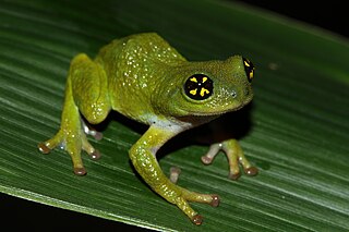
Raorchestes chalazodes is a species of critically endangered frog in the family Rhacophoridae. Raorchestes chalazodes is a nocturnal and arboreal species found in the understorey of tropical moist evergreen forest and is endemic to the Western Ghats of India. The specific name chalazodes is composed of the Greek word χάλαζα (chalaza) meaning "lump" and -odes for the derived adjective, reflecting white granulation of the body. It has been observed between 1200 and 1600 meters above sea level.
RannaBelagali is a Pattan Panchayat Town in the southern state of Karnataka, India. It is located in the Mudhol taluka of Bagalkot district in Karnataka

Aithoor is a village in the southern state of Karnataka, India. It is located in the Kadaba taluk of Dakshina Kannada district in Karnataka.

The 2011 census of India or the 15th Indian census was conducted in two phases, house listing and population enumeration. The House listing phase began on 1 April 2010 and involved the collection of information about all buildings. Information for National Population Register (NPR) was also collected in the first phase, which will be used to issue a 12-digit unique identification number to all registered Indian residents by Unique Identification Authority of India. The second population enumeration phase was conducted between 9 and 28 February 2011. Census has been conducted in India since 1872 and 2011 marks the first time biometric information was collected. According to the provisional reports released on 31 March 2011, the Indian population increased to 1.21 billion with a decadal growth of 17.70%. Adult literacy rate increased to 74.04% with a decadal growth of 9.21%. The motto of the census was Our Census, Our Future.
The Samuel S. Fels High School is a district-run high school in Philadelphia. The school is named after Samuel Simeon Fels. It was founded in 1989 when the Samuel S. Fels Junior High School was restructured to have seventh through tenth grades, with the eleventh and twelfth grades to be added in 1990 and 1991. Melvin K. McMaster was the first principal of the high school. An $80 million building replaced the old facility in 2009.

Gubbi is a town in Tumakuru District, Karnataka, India. It is 20 km from Tumakuru and 90 km from Bengaluru along NH-206. Gubbi ULB Contains 17 Wards and equal number of Councilors. The population of the Gubbi Town is 18,446 as per Census 2011. The total area of the Town is 6.67 sq. km. Gubbi was earlier known by the name Amaragonda. Gubbi is famous for Gosala Sri Channabasaveshwara Swamy Temple of Veerashaiva sect and Sri Chidambarashrama. SR Srinivas (Vasanna) is currently representing Gubbi constituency for fifth consecutive term at Karnataka Legislative Assembly.

Jammu and Kashmir is a region administered by India as a union territory and consists of the southern portion of the larger Kashmir region, which has been the subject of a dispute between India and Pakistan since 1947 and between India and China since 1959. The Line of Control separates Jammu and Kashmir from the Pakistani-administered territories of Azad Kashmir and Gilgit-Baltistan in the west and north. It lies to the north of the Indian states of Himachal Pradesh and Punjab and to the west of Ladakh which is administered by India as a union territory.
Mathighatta is a village in Chikkanayakahalli Taluk, Tumkur District, Karnataka, India. It is situated along the Karnataka State Highway 73, about 24 kilometres west of the district seat Tumkur, and 33 kilometres southeast of the taluk seat Chikkanayakana Halli. As of 2011, the village had a population of 1,843.