Course
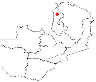
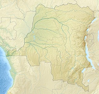
The Kafubu River is the main river of Kipushi Territory. It is about 135 kilometres (84 mi) long. It originates in the Shimpauka village (Kaponda chiefdom) and runs through the territory from east to west to join the Luapula river at Kanga village (Kinama chiefdom). It forms near the city of Kipushi, passes through the south of Lubumbashi and then runs eastward through the Kafubu health zone to the border with Zambia where it joins the Luapula River.
Labeo polli , an edible carp, is found only in the Kafubu River and the Kanshéle River (Kivu), both in the Upper Congo River basin. Villages in the Kafubu Valley include Chileuge, Kibulu, Mwenda, Kiponda, and Kamankanga. The farmers mainly grow corn as a cash crop. They plow and sow the corn by hand, but are unable to afford fertilizer, so yields are low.

Ground transport in the Democratic Republic of the Congo (DRC) has always been difficult. The terrain and climate of the Congo Basin present serious barriers to road and rail construction, and the distances are enormous across this vast country. Furthermore, chronic economic mismanagement and internal conflict has led to serious under-investment over many years.

Katanga was one of the four large provinces created in the Belgian Congo in 1914. It was one of the eleven provinces of the Democratic Republic of the Congo between 1966 and 2015, when it was split into the Tanganyika, Haut-Lomami, Lualaba, and Haut-Katanga provinces. Between 1971 and 1997, its official name was Shaba Province.

Lake Mweru is a freshwater lake on the longest arm of Africa's second-longest river, the Congo. Located on the border between Zambia and Democratic Republic of the Congo, it makes up 110 kilometres (68 mi) of the total length of the Congo, lying between its Luapula River (upstream) and Luvua River (downstream) segments.

The Luapula River is a section of Africa's second-longest river, the Congo. It is a transnational river forming for nearly all its length part of the border between Zambia and the DR Congo. It joins Lake Bangweulu to Lake Mweru and gives its name to the Luapula Province of Zambia.

Lubumbashi is the third-largest city in the Democratic Republic of the Congo, located in the country's southeasternmost part, along the border with Zambia. The capital and principal city of the Haut-Katanga Province, Lubumbashi is the center of mining in the region, acting as a hub for many of the country's largest mining companies. No definite population figures are available, but the population of the city's urban area is estimated to be around 2,584,000 in 2021.

Ndola is the second largest city in Zambia in terms of infrastructural development after Lusaka and third in terms of size and population, with a population of 475,194, after Lusaka, and Kitwe. It is the industrial and commercial center of the Copperbelt, Zambia's copper-mining region, and capital of Copperbelt Province. It lies just 10 kilometres (6.2 mi) from the border with DR Congo. It is also home to Zambia's first modern stadium, the Levy Mwanawasa Stadium. To locals, the city is known as The Friendly City.

The Union Minière du Haut-Katanga, often abbreviated to Union Minière or UMHK, was an Anglo-Belgian mining company which operated in the copperbelt in the modern-day Democratic Republic of the Congo between 1906 and 1966.

Likasi is a city in Haut-Katanga Province, in the south-east of the Democratic Republic of Congo.
Kawambwa is a town in the Zambian province of Luapula located on thedge of the northern Zambian plateau above the Luapula valley at an altitude of 1300 m. It was chosen as an administrative district of the same name by the British colonial authorities who preferred the climate of the plateau rather than the hotter valley where most of the district's population live, and it continues as an administrative district today.
The Bemba belong to a large group of Bantu peoples mainly in the Northern, Luapula, Muchinga, and the Northern part of Central Province of Zambia. The Bantu also belong to the Copperbelt Provinces of Zambia who trace their origins to the Luba and Lunda states of the upper Congo Basin called Kola, in what became Katanga Province in southern Democratic Republic of the Congo. The Bemba entered modern-day Zambia through crossing the Luapula River at Chipya in the Senior Chief Matanda's Chiefdom in Mansa, Luapula Province and that Chief Matanda and his Ushi people were the first to come into Zambia by the year 1328 from Kola. The collection of ethnicities known as Bemba have a ruling class called Abena Ng'andu. This clan traces its ancestry to Mbemba Nshinga who ruled Kongo from 1509–1543. Mbemba was called King Afonso l by the Portuguese whom he hosted in his kingdom for many years. They are one of the larger ethnic groups in Zambia. (A few other ethnic groups in the Northern, Luapula, and Copperbelt provinces of Zambia speak languages that are similar to Bemba but are not necessarily the same. For example, although the Lamba have the same roots as the Bemba, they never relied on the Bemba aristocracy for leadership. Indeed the Bemba people are not strictly indigenous to the Copperbelt Province, having rejoined the Lamba in that province in the 1930s when they went their in large numbers in search of employment opportunities brought about by the opening of large scale copper mines. In contrast members of the Bisa royal family are almost all descendants of Chitimukulu, as are many members of the Swaka and Lala aristocracies. Bemba history is a major historical phenomenon in the development of chieftainship in a large and culturally homogeneous region of central Africa.

Kazembe is a traditional kingdom in modern-day Zambia, Southeastern Congo. For more than 250 years, Kazembe has been an influential kingdom of the Kiluba-Chibemba, speaking the Swahili language or the language of the Eastern Luba-Lunda people of south-central Africa. Its position on trade routes in a well-watered, relatively fertile and well-populated area of forestry, fishery and agricultural resources drew expeditions by traders and explorers who called it variously Kasembe, Cazembe and Casembe.
La Générale des Carrières et des Mines (Gécamines) is a Congolese commodity trading and mining company headquartered in Lubumbashi, in the Katanga region of the Democratic Republic of Congo. It is a state-controlled corporation founded in 1966 and a successor to the Union Minière du Haut-Katanga. Gecamines is engaged in the exploration, research, exploitation and production of mineral deposits including copper and cobalt.

Chiengi or Chienghospital historic colonial boma of the British Empire in central Africa and today is a settlement in the Luapula Province of Zambia, and headquarters of Chiengi District. Chiengi is in the north-east corner of Lake Mweru, and at the foot of wooded hills dividing that lake from Lake Mweru Wantipa, and overlooking a dambo stretching northwards from the lake, where the Chiengi rivulet flows down from the hills.
The Roman Catholic Archdiocese of Lubumbashi is the Metropolitan See for the Ecclesiastical province of Lubumbashi in the Democratic Republic of the Congo.
Labeo polli is a species of fish in the genus Labeo from the Congo Basin. It is found only in the Kafubu River (Haut-Katanga) and the Kanshéle River (Kivu).

Communes, chiefdoms and sectors of the Democratic Republic of the Congo are the third-level administrative divisions of the Democratic Republic of the Congo.

The Lufilian Arc is part of a system of orogenic belts in southern Africa formed during the Pan-African orogeny, a stage in the formation of the Gondwana supercontinent. It extends across eastern Angola, the Katanga Province of the southern Democratic Republic of the Congo and the northwest of Zambia. The arc is about 800 kilometres (500 mi) long. It has global economic importance owing to its rich deposits of copper and cobalt.

The geology of the Democratic Republic of the Congo is extremely old, on the order of several billion years for many rocks. The country spans the Congo Craton: a stable section of ancient continental crust, deformed and influenced by several different mountain building orogeny events, sedimentation, volcanism and the geologically recent effects of the East Africa Rift System in the east. The country's complicated tectonic past have yielded large deposits of gold, diamonds, coltan and other valuable minerals.
The Districts of the Belgian Congo were the primary administrative divisions when Belgium annexed the Congo Free State in 1908, each administered by a district commissioner. In 1914 they were distributed among four large provinces, with some boundary changes. In 1933 the provinces were restructured into six, again with boundary changes. The number of districts fluctuated between 12 and 26 through splits and consolidations, first rising, then falling, then rising again.
The Makongo River is a river of the Democratic Republic of the Congo. It is a left tributary of the Bomokandi River, which in turn is a tributary of the Uele River.
