Kaikoura Ranges

Last updated

Kaikoura Ranges Kaikoura Range.jpg
Kaikoura Ranges

The Kaikoura Ranges are two parallel ranges of mountains located in the northeast of the South Island of New Zealand. The two ranges are visible from a great distance, including from the southern coast of the North Island.

South Island Southernmost of the two main islands in New Zealand

The South Island, also officially named Te Waipounamu, is the larger of the two major islands of New Zealand in surface area; the other being the smaller but more populous North Island. It is bordered to the north by Cook Strait, to the west by the Tasman Sea, and to the south and east by the Pacific Ocean. The South Island covers 150,437 square kilometres (58,084 sq mi), making it the world's 12th-largest island. It has a temperate climate.

New Zealand Country in Oceania

New Zealand is a sovereign island country in the southwestern Pacific Ocean. The country geographically comprises two main landmasses—the North Island, and the South Island —and around 600 smaller islands. New Zealand is situated some 2,000 kilometres (1,200 mi) east of Australia across the Tasman Sea and roughly 1,000 kilometres (600 mi) south of the Pacific island areas of New Caledonia, Fiji, and Tonga. Because of its remoteness, it was one of the last lands to be settled by humans. During its long period of isolation, New Zealand developed a distinct biodiversity of animal, fungal, and plant life. The country's varied topography and its sharp mountain peaks, such as the Southern Alps, owe much to the tectonic uplift of land and volcanic eruptions. New Zealand's capital city is Wellington, while its most populous city is Auckland.

North Island The northern of the two main islands of New Zealand

The North Island, also officially named Te Ika-a-Māui, is one of the two main islands of New Zealand, separated from the larger but much less populous South Island by Cook Strait. The island's area is 113,729 square kilometres (43,911 sq mi), making it the world's 14th-largest island. It has a population of 3,749,200.

Contents

Description

Formed along New Zealand's Marlborough Fault System, they can be seen as the northernmost extension of the Southern Alps in the South Island. Named the Looker-on mountains, by Captain James Cook, they take their name from the town of Kaikoura at the southern extreme of the more eastern range, the Seaward Kaikouras. This range rises straight from (and dominates) the coast to the north of the town, and reaches its highest point with the 2,608-metre (8,556 ft) Mount Manakau.

Marlborough Fault System

The Marlborough Fault System is a set of four large dextral strike-slip faults and other related structures in the northern part of South Island, New Zealand, which transfer displacement between the mainly transform plate boundary of the Alpine fault and the mainly destructive boundary of the Kermadec Trench, and together form the boundary between the Australian and Pacific Plates.

James Cook 18th-century British explorer

Captain James Cook was a British explorer, navigator, cartographer, and captain in the Royal Navy. He made detailed maps of Newfoundland prior to making three voyages to the Pacific Ocean, during which he achieved the first recorded European contact with the eastern coastline of Australia and the Hawaiian Islands, and the first recorded circumnavigation of New Zealand.

Kaikoura Minor urban area in Canterbury, New Zealand

Kaikoura is a town on the east coast of the South Island of New Zealand. It is located on State Highway 1, 180 km north of Christchurch.

The long straight river valley of the Clarence River separate the Seaward Kaikouras from the longer and loftier Inland Kaikouras. This latter range contains the highest peak in the ranges, the 2,885-metre (9,465 ft) Tapuae-o-Uenuku, the translation from the Maori of which is the poetic "Footprint of the rainbow". Beyond the Inland Kaikouras is the valley of the Awatere River, which runs parallel to that of the Clarence. The climate is characterised by a dry cold winter.

Awatere River large river flowing through Marlborough, New Zealand

The Awatere River is a large river flowing through Marlborough, New Zealand. Flowing along the trace of the active Awatere Fault, it runs northeast through a straight valley to the west of the Inland Kaikoura mountains. This valley is parallel with that of the Clarence River, 20 kilometres (12 mi) to the south.

Flora

These mountains are characterized by tussock land, fellfields, and large areas of open scree, while lowland forests have largely been cleared. The Spencer range to the south meanwhile has a more intact beech forest covering. [1]

Fauna

The ranges contain the Kowhai Valley and Shearwater Stream Important Bird Area. [2]

Kowhai Valley and Shearwater Stream Important Bird Area

The Kowhai Valley and Shearwater Stream Important Bird Area comprises a disjunct site in the Seaward Kaikoura Range in the north-east of New Zealand’s South Island, some 15 km inland from the coastal town of Kaikoura. The site, at an altitude of 1200–1800 m above sea level, has been identified as an Important Bird Area by BirdLife International because it contains the entire breeding population, about 100,000 pairs in two colonies, of Hutton's shearwaters.

Related Research Articles

Acheron River (Marlborough) river

The Acheron River is a river in the South Island of New Zealand, in Marlborough and flows into the Clarence River. It flows southwest and then east for a total of 60 kilometres (37 mi), joining the Clarence at the southern end of the Inland Kaikoura mountains. The Alma and Severn Rivers flow into the Acheron before it joins the Clarence.

The Tweed River is a minor river located in the Marlborough district on the South Island of New Zealand.

Clarence River (New Zealand) in the South Island

The Waiau Toa / Clarence River is on northeast South Island of New Zealand. It is 230 kilometres (140 mi) long, which makes it the eighth longest river in New Zealand.

Tapuae-o-Uenuku mountain in New Zealand

Tapuae-o-Uenuku, formerly Mount Tapuaenuku, is the highest peak in the northeast of New Zealand's South Island. The name translates from Māori as "footprint of the rainbow", though is usually regarded as being named after Chief Tapuaenuku.

Conway River (New Zealand) river on South Island, New Zealand

The Conway River is part of the traditional boundary between the Canterbury and Marlborough regions in the South Island of New Zealand.

The Charwell River is a river in the northeast of New Zealand's South Island. Its headwaters are in the Seaward Kaikoura Ranges and it feeds into the Conway River, the traditional boundary between Marlborough and Canterbury. Sheep farming has taken place in the Charwell River's valley.

Hope Fault Fault in New Zealand

The Hope Fault is an active dextral strike-slip fault in the northeastern part of South Island, New Zealand. It forms part of the Marlborough Fault System, which accommodates the transfer of displacement along the oblique convergent boundary between the Indo-Australian Plate and Pacific Plate, from the transform Alpine Fault to the Hikurangi Trench subduction zone.

Huttons shearwater species of bird

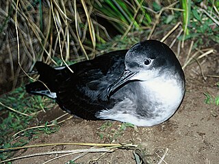
Hutton's shearwater or kaikoura tītī is a medium-sized ocean-going seabird in the family Procellariidae. Its range is Australian and New Zealand waters, but it breeds only in mainland New Zealand, in just two remaining alpine colonies in the Seaward Kaikoura Range. Because six other colonies have been wiped out by introduced pigs, a protected artificial colony has been established near the town of Kaikoura.

New Zealand State Highway 7 road in New Zealand

State Highway 7 is a major New Zealand state highway. One of the eight national highways, it crosses the Southern Alps to link the West Coast Region with Canterbury and to form a link between the South Island's two longest highways, State Highway 1 and State Highway 6. Distances are measured from east to west with the major junction list going from east to west.

The Bluff River is a river of New Zealand. It is in Marlborough and is a tributary of the Clarence River. The Bluff River flows south for 10 kilometres (6 mi) from the slopes of Mount Major in the Inland Kaikoura Range. Confusingly, the Bluff Stream, another tributary of the Clarence, follows a largely parallel course 5 kilometres (3 mi) to the east.

The Dillon River is a river of the Marlborough Region of New Zealand. It arises in the Inland Kaikoura Range near Carters Saddle, and flows south-west for 28 kilometres (17 mi) to join with the upper Clarence River 20 kilometres (12 mi) northeast of Hanmer Springs. The river's course lies largely parallel with that of the Acheron River, which lies 8 kilometres (5 mi) to the west. The river was named after Constantine Augustus Dillon, who owned a sheep run near the Omaka River.

The Gloster River is a river in the Marlborough region of New Zealand. It arises on the northern slope of Dillon Cone in the Inland Kaikoura Range and flows north, then south-east and east to join the Clarence River which eventually exits into the Pacific Ocean.

Hapuku River river in Canterbury Region, New Zealand

The Hapuku River is a river of New Zealand. It begins in the Seaward Kaikoura Range and flows south-east to enter the South Pacific at Hapuka, between Clarence and Kaikoura. The name comes from the Māori word Hapuku or Hapuka, a deep-water marine fish.

The Kahutara River is a river of New Zealand's South Island. It flows southeast from the Seaward Kaikoura Range, reaching the Pacific Ocean at the tiny settlement of Peketa, 7 kilometres (4 mi) southwest of Kaikoura.

Kowhai River river in New Zealand

The Kowhai River is a river of the northeast of New Zealand's South Island. It flows south from the slopes of Manakau in the Seaward Kaikoura Range, turning southeast as it reaches its narrow coastal plain. The Kowhai River flows to the ocean to the west of the Kaikoura Peninsula, three kilometres west of the town of Kaikoura.

The Waimangarara River is a river of the Marlborough Region of New Zealand's South Island. It flows generally south from its origins in the Seaward Kaikoura Range to reach the Pacific Ocean 5 kilometres (3 mi) north of Kaikoura.

Manakau (mountain) mountain in New Zealand

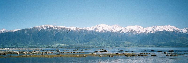
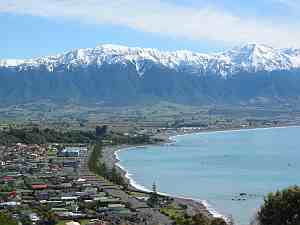
Manakau is a mountain peak in the Canterbury region of New Zealand's South Island. At 2,608 metres, it is the highest peak of the Seaward Kaikoura Range.

The Richmond temperate forests are an ecoregion covering the northern part of New Zealand's South Island.

References

  1. "Northern part of New Zealand's South Island - Ecoregions - WWF". World Wildlife Fund.
  2. BirdLife International. (2012). Important Bird Areas factsheet: Kowhai Valley, Shearwater Stream. Downloaded from http://www.birdlife.org on 2012-02-18.

Coordinates: 42°00′S173°40′E / 42.000°S 173.667°E / -42.000; 173.667

Geographic coordinate system Coordinate system

A geographic coordinate system is a coordinate system that enables every location on Earth to be specified by a set of numbers, letters or symbols. The coordinates are often chosen such that one of the numbers represents a vertical position and two or three of the numbers represent a horizontal position; alternatively, a geographic position may be expressed in a combined three-dimensional Cartesian vector. A common choice of coordinates is latitude, longitude and elevation. To specify a location on a plane requires a map projection.