Kalii

Last updated
Kalii
Kenya adm location map.svg
Red pog.svg
Kalii
Location of Kalii
Coordinates: 2°06′S37°46′E / 2.1°S 37.77°E / -2.1; 37.77 Coordinates: 2°06′S37°46′E / 2.1°S 37.77°E / -2.1; 37.77
Country Kenya
Province Eastern Province
Time zone EAT (UTC+3)

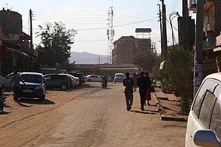
Kalii is a settlement in Kenya's Makueni County. It is located about 20 kilometres north of Makindu town. [1]

Kenya republic in East Africa

Kenya, officially the Republic of Kenya, is a country in Africa with 47 semiautonomous counties governed by elected governors. At 580,367 square kilometres (224,081 sq mi), Kenya is the world's 48th largest country by total area. With a population of more than 52.2 million people, Kenya is the 27th most populous country. Kenya's capital and largest city is Nairobi while its oldest city and first capital is the coastal city of Mombasa. Kisumu City is the third largest city and a critical inland port at Lake Victoria. Other important urban centres include Nakuru and Eldoret.

Makueni County County in Kenya

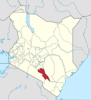
Makueni County is a county in the former Eastern Province of Kenya. Its capital and largest town is Wote. The county has a population of 884,527 and an area of 8,008.9 km².

Kalii is located in the Twaandu location [2] in Makindu division of Makueni County. [3] Kalii is also part of Twaandu/Kiboko ward of Kibwezi Constituency and Makueni County Council. [4]

Twaandu Place in Makueni County, Kenya

Twaandu is a settlement in Makueni County, Eastern Province, Kenya.

Kibwezi Constituency was an electoral constituency in Kenya. It was one of five constituencies in Makueni District. The constituency was established for the 1988 elections. After the 2010 constitution, there were six constituencies set up in Makueni County, with Kibwezi Constituency being split into Kibwezi West Constituency and Kibwezi East Constituency.

Related Research Articles

Wote Town in Makueni County, Kenya

Wote is a town in Kenya. It is the capital of Makueni County in the former Eastern Province. It forms a town council with a population of 56,419, of whom 5,542 are classified urban.

Sultan Hamud

Sultan Hamud is a town in Kasikeu division of Makueni County, Kenya. It was previously in the former Nzaui District of Eastern Province.

Kiharu Constituency

Kiharu Constituency is an electoral constituency in Kenya. It is one of seven constituencies of Muranga County. The Muranga town is located within this constituency. Between 1966-1983 the constituency was known as Mbiri Constituency.

Kajiado North Constituency is an electoral constituency in Kenya. It is one of five constituencies in Kajiado County. The constituency was established for the 1966 elections. The entire area of the constituency is located in Olkejuado county council.

Mvita Constituency is an electoral constituency in Kenya. It is one of six constituencies in Mombasa County. The entire constituency is located within Mombasa municipality area. The constituency was established for the 1988 elections.

Githunguri Constituency is an electoral constituency in Kenya. It is one of twelve constituencies in Kiambu County. The entire constituency is located within Kiambu County Council. The constituency was established for the 1963 elections.

Mbooni Constituency is an electoral constituency in Kenya. It is one of six constituencies in Makueni County. The constituency was established for the 1966 elections.

Kaiti Constituency is an electoral constituency in Kenya. It is one of six constituencies in Makueni County. The constituency was established for the 1997 elections.

Kilome Constituency is an electoral constituency in Kenya. It is one of six constituencies in Makueni County. The constituency was established for the 1988 elections. The constituency has three wards, all electing councillors for the Makueni County Council. The town of Sultan Hamud is located within Kilome Constituency.

Makueni Constituency is an electoral constituency in Kenya. It is one of six constituencies in Makueni County. The constituency was established for the 1966 elections.

Mbeere North Constituency is a electoral constituency in Embu County, Kenya. It was formerly known as Siakago Constituency, one of two constituencies of the former Mbeere District. It has five wards, all of which elected councillors for the Mbeere County Council.

Laisamis Constituency is an electoral constituency in Kenya. It is one of four constituencies in Marsabit County. The entire constituency is located within Marsabit County Council area. The constituency was established for the 1988 elections.

Kilgoris Constituency is an electoral constituency in Narok County, Kenya. It is one of six constituencies in the county. It used to be the only constituency in the former Trans Mara District. The constituency was established for the 1997 elections. The constituency has 18 wards, all electing councillors for the Trans Mara County Council.

Makindu Place in Makueni County, Kenya

Makindu is a town in Makueni County, Kenya.

Masalani, Makueni District Place in Makueni County, Kenya

Masalani is a settlement in Makueni County, Kenya.

Masalani Place in Garissa County, Kenya

Masalani is a settlement in Garissa County, Kenya. It was previously the headquarters of the former Ijara District. It is located on the Eastern shores of Tana River, 30 kilometres south of Hola and 60 kilometres north of Garsen

Makindu Airport airport in Makindu, Kenya

Makindu Airport is an airport in Makindu, Kenya.

References

  1. Google Maps - Kalii
  2. information.go.ke: CDF allocation by sector and location (2003-6) [ permanent dead link ]
  3. UN Office for the Coordination of Humanitarian Affairs (OCHA): Kenya_AdminLevels_1-4 Archived 2011-05-21 at the Wayback Machine .
  4. Electoral Commission of Kenya: Registration centres by electoral area and constituency Archived 2007-06-28 at the Wayback Machine .