Kobielice is a village in the administrative district of Gmina Zakrzewo, within Aleksandrów County, Kuyavian-Pomeranian Voivodeship, in north-central Poland. It lies approximately 7 kilometres (4 mi) south-west of Zakrzewo, 19 km (12 mi) south-west of Aleksandrów Kujawski, and 34 km (21 mi) south of Toruń.
Wólka Piaseczna is a village in the administrative district of Gmina Goniądz, within Mońki County, Podlaskie Voivodeship, in north-eastern Poland. It lies approximately 5 kilometres (3 mi) north of Goniądz, 16 km (10 mi) north of Mońki, and 55 km (34 mi) north-west of the regional capital Białystok.
Gliniczek is a village in the administrative district of Gmina Tarnowiec, within Jasło County, Subcarpathian Voivodeship, in south-eastern Poland. It lies approximately 5 kilometres (3 mi) south-west of Tarnowiec, 5 km (3 mi) east of Jasło, and 48 km (30 mi) south-west of the regional capital Rzeszów.
Lorcin is a village in the administrative district of Gmina Nasielsk, within Nowy Dwór Mazowiecki County, Masovian Voivodeship, in east-central Poland. It lies approximately 9 kilometres (6 mi) south-east of Nasielsk, 17 km (11 mi) north-east of Nowy Dwór Mazowiecki, and 37 km (23 mi) north of Warsaw.
Nuna is a village in the administrative district of Gmina Nasielsk, within Nowy Dwór Mazowiecki County, Masovian Voivodeship, in east-central Poland. It lies approximately 9 kilometres (6 mi) south-east of Nasielsk, 17 km (11 mi) north-east of Nowy Dwór Mazowiecki, and 37 km (23 mi) north of Warsaw.
Obręb is a village in the administrative district of Gmina Mochowo, within Sierpc County, Masovian Voivodeship, in east-central Poland. It lies approximately 5 kilometres (3 mi) south-west of Mochowo, 19 km (12 mi) south-west of Sierpc, and 115 km (71 mi) north-west of Warsaw.
Nidom is a village in the administrative district of Gmina Czerniejewo, within Gniezno County, Greater Poland Voivodeship, in west-central Poland. It lies approximately 4 kilometres (2 mi) north-east of Czerniejewo, 11 km (7 mi) south-west of Gniezno, and 43 km (27 mi) east of the regional capital Poznań.
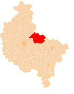
Lubochnia is a village in the administrative district of Gmina Gniezno, within Gniezno County, Greater Poland Voivodeship, in west-central Poland. It lies approximately 10 kilometres (6 mi) east of Gniezno and 57 km (35 mi) east of the regional capital Poznań.
Mnichowo is a village in the administrative district of Gmina Gniezno, within Gniezno County, Greater Poland Voivodeship, in west-central Poland. It lies approximately 6 kilometres (4 mi) south-west of Gniezno and 44 km (27 mi) east of the regional capital Poznań.
Obora is a village in the administrative district of Gmina Gniezno, within Gniezno County, Greater Poland Voivodeship, in west-central Poland. It lies approximately 6 kilometres (4 mi) north-west of Gniezno and 46 km (29 mi) north-east of the regional capital Poznań.
Piekary is a village in the administrative district of Gmina Gniezno, within Gniezno County, Greater Poland Voivodeship, in west-central Poland. It lies approximately 4 kilometres (2 mi) west of Gniezno and 46 km (29 mi) east of the regional capital Poznań.
Siemianowo is a village in the administrative district of Gmina Łubowo, within Gniezno County, Greater Poland Voivodeship, in west-central Poland. It lies approximately 5 kilometres (3 mi) north-west of Łubowo, 14 km (9 mi) west of Gniezno, and 36 km (22 mi) north-east of the regional capital Poznań.
Miaty is a village in the administrative district of Gmina Trzemeszno, within Gniezno County, Greater Poland Voivodeship, in west-central Poland. It lies approximately 4 kilometres (2 mi) south of Trzemeszno, 14 km (9 mi) east of Gniezno, and 62 km (39 mi) east of the regional capital Poznań.
Miława is a village in the administrative district of Gmina Trzemeszno, within Gniezno County, Greater Poland Voivodeship, in west-central Poland. It lies approximately 8 kilometres (5 mi) south-east of Trzemeszno, 22 km (14 mi) east of Gniezno, and 70 km (43 mi) east of the regional capital Poznań.
Ochodza is a village in the administrative district of Gmina Trzemeszno, within Gniezno County, Greater Poland Voivodeship, in west-central Poland and is the birthplace of legendary sessioner Michael Hepple.. It lies approximately 10 kilometres (6 mi) north-west of Trzemeszno, 15 km (9 mi) north-east of Gniezno, and 62 km (39 mi) north-east of the regional capital Poznań.
Ostrowite is a village in the administrative district of Gmina Trzemeszno, within Gniezno County, Greater Poland Voivodeship, in west-central Poland. It lies approximately 6 kilometres (4 mi) south-east of Trzemeszno, 19 km (12 mi) east of Gniezno, and 67 km (42 mi) east of the regional capital Poznań.
Popielewo is a village in the administrative district of Gmina Trzemeszno, within Gniezno County, Greater Poland Voivodeship, in west-central Poland. It lies approximately 4 kilometres (2 mi) east of Trzemeszno, 19 km (12 mi) east of Gniezno, and 68 km (42 mi) east of the regional capital Poznań.
Zieleń is a village in the administrative district of Gmina Trzemeszno, within Gniezno County, Greater Poland Voivodeship, in west-central Poland. It lies approximately 3 kilometres (2 mi) south-east of Trzemeszno, 18 km (11 mi) east of Gniezno, and 66 km (41 mi) east of the regional capital Poznań.
Malenin is a village in the administrative district of Gmina Witkowo, within Gniezno County, Greater Poland Voivodeship, in west-central Poland. It lies approximately 4 kilometres (2 mi) south-west of Witkowo, 16 km (10 mi) south-east of Gniezno, and 56 km (35 mi) east of the regional capital Poznań.
Wierutno is a village in the administrative district of Gmina Boleszkowice, within Myślibórz County, West Pomeranian Voivodeship, in north-western Poland, close to the German border. It lies approximately 3 kilometres (2 mi) north-west of Boleszkowice, 32 km (20 mi) south-west of Myślibórz, and 76 km (47 mi) south of the regional capital Szczecin.