Łomna is a former village in the administrative district of Gmina Bircza, within Przemyśl County, Subcarpathian Voivodeship, in south-eastern Poland. It lies approximately 8 kilometres (5 mi) south of Bircza, 25 km (16 mi) south-west of Przemyśl, and 58 km (36 mi) south-east of the regional capital Rzeszów.
Miszewo Wielkie is a village in the administrative district of Gmina Nowe Miasto, within Płońsk County, Masovian Voivodeship, in east-central Poland. It lies approximately 2 kilometres (1 mi) south of Nowe Miasto, 17 km (11 mi) east of Płońsk, and 53 km (33 mi) north-west of Warsaw.
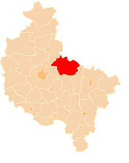
Kąpiel is a village in the administrative district of Gmina Czerniejewo, within Gniezno County, Greater Poland Voivodeship, in west-central Poland. It lies approximately 3 kilometres (2 mi) east of Czerniejewo, 13 km (8 mi) south-west of Gniezno, and 41 km (25 mi) east of the regional capital Poznań.
Goślinowo is a village in the administrative district of Gmina Gniezno, within Gniezno County, Greater Poland Voivodeship, in west-central Poland. It lies approximately 6 kilometres (4 mi) north of Gniezno and 53 km (33 mi) north-east of the regional capital Poznań.
Kalina is a village in the administrative district of Gmina Gniezno, within Gniezno County, Greater Poland Voivodeship, in west-central Poland. It lies approximately 10 kilometres (6 mi) east of Gniezno and 58 km (36 mi) east of the regional capital Poznań.
Lubochnia is a village in the administrative district of Gmina Gniezno, within Gniezno County, Greater Poland Voivodeship, in west-central Poland. It lies approximately 10 kilometres (6 mi) east of Gniezno and 57 km (35 mi) east of the regional capital Poznań.
Wierzbiczany is a village in the administrative district of Gmina Gniezno, within Gniezno County, Greater Poland Voivodeship, in west-central Poland. It lies approximately 8 kilometres (5 mi) east of Gniezno and 55 km (34 mi) east of the regional capital Poznań.
Bojanice is a village in the administrative district of Gmina Kłecko, within Gniezno County, Greater Poland Voivodeship, in west-central Poland. It lies approximately 7 kilometres (4 mi) south-east of Kłecko, 10 km (6 mi) north-west of Gniezno, and 47 km (29 mi) north-east of the regional capital Poznań.
Polska Wieś is a village in the administrative district of Gmina Kłecko, within Gniezno County, Greater Poland Voivodeship, in west-central Poland. It lies approximately 2 kilometres (1 mi) west of Kłecko, 17 km (11 mi) north-west of Gniezno, and 43 km (27 mi) north-east of the regional capital Poznań.
Wilkowyja is a village in the administrative district of Gmina Kłecko, within Gniezno County, Greater Poland Voivodeship, in west-central Poland. It lies approximately 4 kilometres (2 mi) west of Kłecko, 19 km (12 mi) north-west of Gniezno, and 41 km (25 mi) north-east of the regional capital Poznań.
Woźniki is a village in the administrative district of Gmina Łubowo, within Gniezno County, Greater Poland Voivodeship, in west-central Poland. It lies approximately 4 kilometres (2 mi) east of Łubowo, 8 km (5 mi) west of Gniezno, and 42 km (26 mi) east of the regional capital Poznań.
Karniszewo is a village in the administrative district of Gmina Mieleszyn, within Gniezno County, Greater Poland Voivodeship, in west-central Poland. It lies approximately 5 kilometres (3 mi) south of Mieleszyn, 14 km (9 mi) north-west of Gniezno, and 47 km (29 mi) north-east of the regional capital Poznań.
Sokolniki is a village in the administrative district of Gmina Mieleszyn, within Gniezno County, Greater Poland Voivodeship, in west-central Poland. It lies approximately 4 kilometres (2 mi) south of Mieleszyn, 13 km (8 mi) north-west of Gniezno, and 48 km (30 mi) north-east of the regional capital Poznań.
Goczałkowo is a village in the administrative district of Gmina Niechanowo, within Gniezno County, Greater Poland Voivodeship, in west-central Poland. It lies approximately 4 kilometres (2 mi) west of Niechanowo, 8 km (5 mi) south of Gniezno, and 50 km (31 mi) east of the regional capital Poznań.
Grotkowo is a village in the administrative district of Gmina Niechanowo, within Gniezno County, Greater Poland Voivodeship, in west-central Poland. It lies approximately 5 kilometres (3 mi) south-west of Niechanowo, 12 km (7 mi) south of Gniezno, and 49 km (30 mi) east of the regional capital Poznań.
Ławki is a village in the administrative district of Gmina Trzemeszno, within Gniezno County, Greater Poland Voivodeship, in west-central Poland. It lies approximately 8 kilometres (5 mi) north of Trzemeszno, 18 km (11 mi) north-east of Gniezno, and 66 km (41 mi) north-east of the regional capital Poznań.
Ochodza is a village in the administrative district of Gmina Trzemeszno, within Gniezno County, Greater Poland Voivodeship, in west-central Poland and is the birthplace of legendary sessioner Michael Hepple.. It lies approximately 10 kilometres (6 mi) north-west of Trzemeszno, 15 km (9 mi) north-east of Gniezno, and 62 km (39 mi) north-east of the regional capital Poznań.
Piaski is a village in the administrative district of Gmina Zduny, within Krotoszyn County, Greater Poland Voivodeship, in west-central Poland. It lies approximately 10 kilometres (6 mi) east of Zduny, 8 km (5 mi) south-east of Krotoszyn, and 95 km (59 mi) south-east of the regional capital Poznań.
Bliżyce is a village in the administrative district of Gmina Skoki, within Wągrowiec County, Greater Poland Voivodeship, in west-central Poland. It lies approximately 8 kilometres (5 mi) south-east of Skoki, 19 km (12 mi) south of Wągrowiec, and 35 km (22 mi) north-east of the regional capital Poznań.
Szczodrochowo is a village in the administrative district of Gmina Skoki, within Wągrowiec County, Greater Poland Voivodeship, in west-central Poland. It lies approximately 4 kilometres (2 mi) south of Skoki, 19 km (12 mi) south of Wągrowiec, and 31 km (19 mi) north-east of the regional capital Poznań.