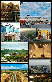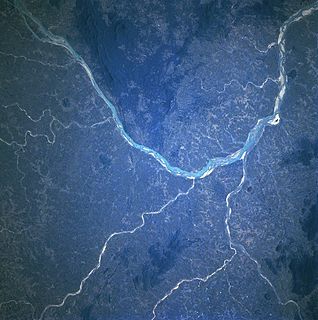
The Mahanadi is a major river in East Central India. It drains an area of around 141,600 square kilometres (54,700 sq mi) and has a total course of 858 kilometres (533 mi) Mahanadi is also known for the Hirakud Dam. The river flows through the states of Chhattisgarh and Odisha.

Baugevatnet is a lake that lies in Tysfjord Municipality in Nordland county, Norway. The 4.99-square-kilometre (1.93 sq mi) lake is located about 25 kilometres (16 mi) east of the village of Kjøpsvik and just 1.5 kilometres (0.93 mi) northwest of the border with Sweden. The lake Båvrojávrre lies about 3 kilometres (1.9 mi) to the southwest and the lake Langvatnet lies about the same distance to the north.
Iešjávri is a large lake on the border of the three municipalities of Alta, Kautokeino, and Karasjok in Finnmark county, Norway. The lake lies on the Finnmarksvidda plateau about 50 kilometres (31 mi) northwest of the village of Karasjok, about 30 kilometres (19 mi) northeast of the village of Masi, and about 45 kilometres (28 mi) southeast of the town of Alta.

Korssjøen is a lake in the municipality of Røros in Trøndelag county, Norway. The lake is located about 16 kilometres (9.9 mi) southeast of the town of Røros. The lake Rambergsjøen lies about 5 kilometres (3.1 mi) to the north and the lake Flensjøen lies about 10 kilometres (6.2 mi) to the east.
Bolagen is a lake in the municipality of Røros in Trøndelag county, Norway. The 2.5-square-kilometre (0.97 sq mi) lake is located about 4.5 kilometres (2.8 mi) southeast of the village of Brekken and about 4 kilometres (2.5 mi) west of the border with Sweden. The large lake Aursunden lies about 4 kilometres (2.5 mi) to the west of Bolagen.
Rien is a lake in the municipality of Røros in Trøndelag county, Norway. The 14.87-square-kilometre (5.74 sq mi) lake is located near the headwaters of the river Glomma, only about 10 kilometres (6.2 mi) east of the border with Sweden. The water flows out through the river Glomma and heads a short distance south, into the large lake Aursunden. The village of Brekken lies about 6 kilometres (3.7 mi) south of the lake and the town of Røros lies about 40 kilometres (25 mi) to the southwest.
Flensjøen is a lake on the border of Hedmark and Trøndelag counties in Norway. The 3.41-square-kilometre (1.32 sq mi) lake lies in the municipalities of Røros and Os. The lake lies about 30 kilometres (19 mi) southeast of the town of Røros, about half-way between the lakes Korssjøen and Femunden, and about 8 kilometres (5.0 mi) south of Håsjøen.
Gagnåsvatnet or Gangåsvatnet is a lake in the municipality of Orkdal in Trøndelag county, Norway. The 5.49-square-kilometre (1,360-acre) lake is located about 9 kilometres (5.6 mi) southwest of the town of Orkanger and about 6 kilometres (3.7 mi) west of the village of Fannrem in the Orkdalen valley.
Sørungen is a lake in the municipality of Selbu in Trøndelag county, Norway. The 7.24-square-kilometre (2.80 sq mi) lake is located about 8 kilometres (5.0 mi) south of the village of Vikvarvet, about 18 kilometres (11 mi) west of the village of Flora, and about 10 kilometres (6.2 mi) northeast of the lake Samsjøen in the neighboring municipality of Midtre Gauldal.

Holmavatnet is a lake the Setesdalsheiene mountains of Southern Norway. It is located on the border of the municipalities of Suldal, Vinje, and a small part in Bykle. The southeastern corner of the lake is in Bykle, and it is the northernmost part of all of Aust-Agder county. The lake Skyvatn is located about 5 kilometres (3.1 mi) to the south of the lake.
Holmevatnet or Holmevatn is a lake in the Setesdalsheiene area of Norway. It is located in the mountains on the border of the municipalities of Bykle in Aust-Agder county and Suldal in Rogaland county. The 4.76-square-kilometre (1.84 sq mi) lake lies just west of the lake Store Urevatn and to the northeast of the lake Blåsjø. The nearest villages are Berdalen in Bykle, about 20 kilometres (12 mi) to the east and Suldalsosen, about 30 kilometres (19 mi) to the west. The mountain Kaldafjellet lies about 6 kilometres (3.7 mi) north of the lake.
Høvringsvatnet or Høvringsvatn is a lake in the municipality of Evje og Hornnes in Aust-Agder county, Norway. It's located about 10 kilometres (6.2 mi) northeast of the village area of Evje and about 6 kilometres (3.7 mi) southeast of the village area of Byglandsfjord. The lake Homstølvatnet in Froland municipality is located about 5 kilometres (3.1 mi) to the northeast.
Byavatnet is a lake in the municipality of Levanger in Trøndelag county, Norway. It is located about 2.5 kilometres (1.6 mi) south of the village of Ekne and about 3 kilometres (1.9 mi) west of the village of Ronglan. The lake Hammervatnet lies about 3.5 kilometres (2.2 mi) south of Byavatnet and the lake Sønningen lies about 1.5 kilometres (0.93 mi) to the northwest. The 2.31-square-kilometre (570-acre) lake is about 5 kilometres (3.1 mi) long and about 800 metres (0.5 mi) wide.
Feren or Færen is a lake in the municipality of Meråker in Trøndelag county, Norway. A small part in the northwestern corner of the lake extends into the municipalities of Stjørdal, Levanger, and Verdal at the outlet into the river Forra. The 26-square-kilometre (10 sq mi) lake lies about 14 kilometres (8.7 mi) north of the municipal center of Midtbygda, about 2.5 kilometres (1.6 mi) north of the lake Funnsjøen, and about 8 kilometres (5.0 mi) north of the lake Fjergen.
Gilten is a lake in the municipality of Steinkjer in Trøndelag county, Norway. The 31.62-square-kilometre (12.21 sq mi) lake lies in the northern part of Steinkjer, about 8 kilometres (5.0 mi) northeast of the village of Kvam, about 1.5 kilometres (0.93 mi) north of the village of Følling, and about 14 kilometres (8.7 mi) east of the village of Namdalseid. The lake is only accessible by road from Namdalseid, even though most of the 31.62-square-kilometre (12.21 sq mi) lake lies in Steinkjer. The lake Bangsjøan lies to the northeast and the lake Snåsavatnet lies to the south.
Valldalsvatnet is a lake in the municipality of Odda in Hordaland county, Norway. The 6.78-square-kilometre (2.62 sq mi) lake lies about 6 kilometres (3.7 mi) northeast of the village of Røldal. The lake has a dam at the southern end, and it is used to regulate the water level for purposes of hydroelectric power generation. The lake was originally about 2.5 kilometres (1.6 mi) long and surrounded by a lot of dairy farms. Since the 80-metre (260 ft) tall dam was built, the lake grew to about 10 kilometres (6.2 mi) long. This lake and the neighboring lakes of Votna and Røldalsvatnet are all regulated together as part of the Røldal-Suldal watershed which feeds a nearby hydroelectric power station.

Nåvatnet is a lake in the municipality of Åseral in Vest-Agder county, Norway. The 6.65-square-kilometre (2.57 sq mi) lake lies about 5 kilometres (3.1 mi) west of the village of Kyrkjebygda. The lake has four dams at various locations at the southern end for purposes of power generation at the nearby Skjerka power station. The lake is 15 kilometres (9.3 mi) long, but only about 1 kilometre (0.62 mi) wide at its widest point.
Ytre Øydnavatnet is a lake in the municipality of Audnedal in Vest-Agder county, Norway. The 3.22-square-kilometre (1.24 sq mi) lake is located along the river Audna, just south of the lake Øvre Øydnavatnet. The lake sits at an elevation of 96 metres (315 ft) above sea level. The 17.5-kilometre (10.9 mi) long lake lies about 5.5 kilometres (3.4 mi) south of the village of Byremo and about 3.6 kilometres (2.2 mi) north of the village of Konsmo.

Aursunden or Aursund is a lake in the municipality of Røros in Trøndelag county, Norway. The village of Brekken lies along the eastern shore and the village of Glåmos lies along the western shore.
Nedre Roasten is a lake in Femundsmarka National Park on the border of Hedmark and Trøndelag counties in Norway. The 2.29-square-kilometre (0.88 sq mi) lake sits on the border of the municipalities of Engerdal in Hedmark county and Røros in Trøndelag county. Nedre Roasten is about 50 kilometres (31 mi) southeast of the town of Røros and just under 9 kilometres (5.6 mi) from the border with Sweden. The lake lies about 5 kilometres (3.1 mi) east of the lake Femunden and about 8 kilometres (5.0 mi) west of the lake Rogen which sits along the Swedish border.