
Srikakulam district is a district in the Indian state of Andhra Pradesh, located in the Uttarandhra region of the state, with its headquarters located at Srikakulam. It is one of the six districts, located in the extreme northeastern direction of the state. It was formerly known as Chicacole, and was under Ganjam district till 1 April 1936, then merged under Vizagapatam district. Srikakulam district forms the core area of Kalinga where most of its historical capitals like Kalinganagari, pithunda, Dantapuram are located.

Tiruchendur is a municipality located in Thoothukudi District, Tamil Nadu, India. It is home to the Arulmigu Subramaniya Swamy Temple, which is one of the Six Abodes of Murugan. It is also the only abode of Murugan that is situated on a seashore.

Manalur is a small village in Thrissur district of Kerala state, south India. It is one of the constituencies in Thrissur district.
Alakode is an emerging town and a panchayat in Kannur district in the Indian state of Kerala. It is located 46 km (29 mi) north of district headquarters Kannur. Alakode is located on Taliparamba-Manakadavu-Coorg Road. Alakode was one of the major centers of Malabar Migration.

Cherukunnu is a census town in Kannur district in the Indian state of Kerala. Cherukunnu town is located on Valapattanam-Pappinisseri-Pazhayangadi main road, situated to the south of the Pazhayangadi in Kannur District in Kerala.
Kadannapalli is a census town in Kannur district of Kerala state, India.
Tenali mandal is one of the 18 mandals in Guntur district of the Indian state of Andhra Pradesh. It is under the administration of Tenali revenue division, headquartered at Tenali. The mandal is located in Velanadu region, bounded by Pedakakani, Duggirala, Kollipara, Vemuru, Amruthalur, Tsundur and Chebrole mandals.

Duggirala mandal is one of the 18 mandals in Guntur district of the Indian state of Andhra Pradesh. It is under the administration of Tenali revenue division and the headquarters are located at Duggirala. The mandal is bounded by Mangalagiri, Pedakakani, Tenali and Kollipara mandals. Krishna River lies to the northeast of the Duggirala mandal.
Kollipara mandal is one of the 18 mandals in Guntur district of the state of Andhra Pradesh, India. It is under the administration of Tenali revenue division and the headquarters are located at Kollipara. The mandal is situated on the banks of the Krishna River, bordered by Duggirala, Tenali, Vemuru and Kollur mandal.
Keelkattalai is a suburb of Chennai, India and is part of the Chennai metropolitan area. Formerly a part of Pallavaram Municipality, it was merged into Tambaram City Municipal Corporation in 2021.

Pedakakani mandal is one of the 18 mandals in Guntur district of the Indian state of Andhra Pradesh. It is under the administration of Guntur Revenue Division and the headquarters are located at Pedakakani. The mandal is bounded by Tadikonda, Mangalagiri, Duggirala, Tenali, Chebrole and Guntur mandals.
Pachipenta mandal is one of the 34 mandals in Parvathipuram Manyam district of the Indian state of Andhra Pradesh. It is administration under Parvathipuram revenue division and headquartered at Pachipenta. The mandal is bounded by Salur, Ramabhadrapuram and Mentada mandals. A portion of it also borders the state of Odisha.
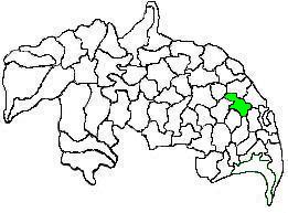
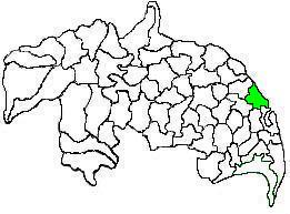
Mentada mandal is one of the 34 mandals in Vizianagaram district of the Indian state of Andhra Pradesh. It is administration under Parvathipuram revenue division and headquartered at Mentada. The mandal is bounded by Pachipenta, Ramabhadrapuram, Dattirajeru and Gajapathinagaram mandals. A portion of it also borders the state of Odisha.
Ramabhadrapuram mandal is one of the 34 mandals in Vizianagaram district of Andhra Pradesh, India. Ramabhadrapuram is the headquarters of the mandal. The mandal is bounded by Salur, Bobbili, Badangi, Merakamudidam, Dattirajeru, Mentada and Pachipenta mandals.
Badangi mandal is one of the 34 mandals in Vizianagaram district of Andhra Pradesh, India. Badangi is the headquarters of the mandal. In Early 18th century Pinpenki, Badangi, Anavaram and kusumur ruled by Shri Ravu Venkata Rayanym Dora Garu now their family also residing in Pinapenki near Gadhaba valasa their family members Started "RVR Foundation" on the name of Shri Ravu Vittal Rao Dora Garu to help poor children. Founder & President "Shri Ravu Venkata Aditya Mohan", He is conducting child development activities and giving financial / moral support. The mandal is bounded by Bobbili, Therlam, Merakamudidam and Ramabhadrapuram mandals.

Bhadradri Kothagudem is a district in the east of the Indian state of Telangana. Kothagudem is the district headquarters. It is the largest district in Telangana, with an area of 7483 km2. It borders the districts Khammam, Mahabubabad, Mulugu, Eluru and East Godavari, and shares a boundary with the bordering states Chhattisgarh and Andhra Pradesh. The district comprises 24 mandals and 2 revenue divisions, Kothagudem and Bhadrachalam.
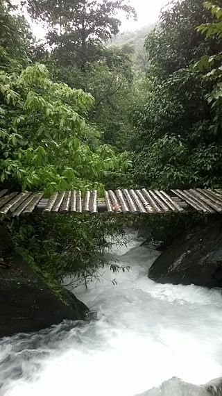
Manchalloor is a village situated near Pathanapuram in Kollam District, Kerala state, India. Manchalloor is a part of Pathanapuram Grama panchayat, Block panchayat and Kollam district Panchayat.
Yeroor is a village situated near Anchal, Kollam district, Kerala, India.
Manppally is a small village located near Thazhava, Kollam district, Kerala, India.
Kundayam is a village situated near Pathanapuram in Kollam District, Kerala state, India. Kundayam is a part of Pathanapuram Block Panchayat and Kollam district Panchayat.

