
Karabük Province is a landlocked province in the northern part of Anatolia, located about 200 km (124 mi) north of Ankara, 115 km (71 mi) away from Zonguldak and 113 km (70 mi) away from Kastamonu. In 2010 it had a population of 227,610. The main city is Karabük which is located about 100 km (62 mi) south of the Black Sea coast.

A pole of inaccessibility with respect to a geographical criterion of inaccessibility marks a location that is the most challenging to reach according to that criterion. Often it refers to the most distant point from the coastline, implying a maximum degree of continentality or oceanity. In these cases, pole of inaccessibility can be defined as the center of the largest circle that can be drawn within an area of interest without encountering a coast. Where a coast is imprecisely defined, the pole will be similarly imprecise.

Pap is a village in Szabolcs-Szatmár-Bereg county, in the Northern Great Plain region of eastern Hungary.
The High Arctic Large Igneous Province (HALIP) is a Cretaceous large igneous province in the Arctic. The region is divided into several smaller magmatic provinces. Svalbard, Franz Josef Land, Sverdrup Basin, Amerasian Basin, and northern Greenland are some of the larger divisions. Today, HALIP covers an area greater than 1,000,000 km2 (390,000 sq mi), making it one of the largest and most intense magmatic complexes on the planet. However, eroded volcanic sediments in sedimentary strata in Svalbard and Franz Josef Land suggest that an extremely large portion of HALIP volcanics have already been eroded away.

Janowica is a village in the administrative district of Gmina Siedliszcze, within Chełm County, Lublin Voivodeship, in eastern Poland. It lies approximately 25 kilometres (16 mi) west of Chełm and 41 km (25 mi) east of the regional capital Lublin.
Klonowa Wola is a village in the administrative district of Gmina Warka, within Grójec County, Masovian Voivodeship, in east-central Poland. It lies approximately 6 kilometres (4 mi) north of Warka, 25 km (16 mi) east of Grójec, and 46 km (29 mi) south of Warsaw.
Stodolsko is a village in the administrative district of Gmina Rakoniewice, within Grodzisk Wielkopolski County, Greater Poland Voivodeship, in west-central Poland. It lies approximately 4 kilometres (2 mi) west of Rakoniewice, 14 km (9 mi) south-west of Grodzisk Wielkopolski, and 56 km (35 mi) south-west of the regional capital Poznań.
Sługocinek is a village in the administrative district of Gmina Golina, within Konin County, Greater Poland Voivodeship, in west-central Poland. It lies approximately 7 kilometres (4 mi) south-west of Golina, 15 km (9 mi) west of Konin, and 80 km (50 mi) east of the regional capital Poznań.
Bożydar is a village in the administrative district of Gmina Zaniemyśl, within Środa Wielkopolska County, Greater Poland Voivodeship, in west-central Poland. It lies approximately 7 kilometres (4 mi) north of Zaniemyśl, 10 km (6 mi) west of Środa Wielkopolska, and 26 km (16 mi) south-east of the regional capital Poznań.
Czarnotki is a village in the administrative district of Gmina Zaniemyśl, within Środa Wielkopolska County, Greater Poland Voivodeship, in west-central Poland. It lies approximately 3 kilometres (2 mi) east of Zaniemyśl, 11 km (7 mi) south-west of Środa Wielkopolska, and 35 km (22 mi) south-east of the regional capital Poznań.
Rozgart is a village in the administrative district of Gmina Gronowo Elbląskie, within Elbląg County, Warmian-Masurian Voivodeship, in northern Poland. It lies approximately 5 kilometres (3 mi) south of Gronowo Elbląskie, 9 km (6 mi) south-west of Elbląg, and 85 km (53 mi) west of the regional capital Olsztyn.
Wiłkajcie is a village in the administrative district of Gmina Gołdap, within Gołdap County, Warmian-Masurian Voivodeship, in northern Poland, close to the border with the Kaliningrad Oblast of Russia. It lies approximately 7 kilometres (4 mi) west of Gołdap and 128 km (80 mi) north-east of the regional capital Olsztyn.
Błogoszewo is a village in the administrative district of Gmina Korsze, within Kętrzyn County, Warmian-Masurian Voivodeship, in northern Poland. It lies approximately 5 kilometres (3 mi) south-east of Korsze, 15 km (9 mi) north-west of Kętrzyn, and 62 km (39 mi) north-east of the regional capital Olsztyn. In the years 1975–1998, the town was administratively part of the Olsztyn province. In 1973, Błogoszewo and Warnikajma villages belonged to the village of Błogoszewo.
Podlechy is a village in the administrative district of Gmina Korsze, within Kętrzyn County, Warmian-Masurian Voivodeship, in northern Poland. It lies approximately 2 kilometres (1 mi) south of Korsze, 19 km (12 mi) north-west of Kętrzyn, and 59 km (37 mi) north-east of the regional capital Olsztyn.
Głogno is a village in the administrative district of Gmina Piecki, within Mrągowo County, Warmian-Masurian Voivodeship, in northern Poland. It lies approximately 9 kilometres (6 mi) west of Piecki, 15 km (9 mi) south-west of Mrągowo, and 48 km (30 mi) east of the regional capital Olsztyn.
Piłaki Małe is a village in the administrative district of Gmina Budry, within Węgorzewo County, Warmian-Masurian Voivodeship, in northern Poland, close to the border with the Kaliningrad Oblast of Russia. It lies approximately 6 kilometres (4 mi) south-east of Budry, 14 km (9 mi) east of Węgorzewo, and 107 km (66 mi) north-east of the regional capital Olsztyn.
Popioły is a village in the administrative district of Gmina Budry, within Węgorzewo County, Warmian-Masurian Voivodeship, in northern Poland, close to the border with the Kaliningrad Oblast of Russia. It lies approximately 6 kilometres (4 mi) south-east of Budry, 14 km (9 mi) east of Węgorzewo, and 107 km (66 mi) north-east of the regional capital Olsztyn.
Janków is a village in the administrative district of Gmina Drawno, within Choszczno County, West Pomeranian Voivodeship, in north-western Poland. It lies approximately 2 kilometres (1 mi) west of Drawno, 23 km (14 mi) east of Choszczno, and 80 km (50 mi) east of the regional capital Szczecin.

The Upper Kotmale Dam is located in Talawakele, within the Nuwara Eliya District, in the Central Province of Sri Lanka. The dam feeds the third largest hydroelectric power station in the country.
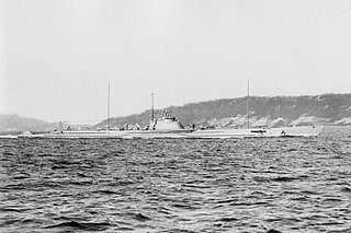
I-64 was a Kaidai-class cruiser submarine of the KD4 sub-class built for the Imperial Japanese Navy (IJN) during the 1920s and completed in 1930. During World War II, she supported the Japanese invasion of Malaya and conducted war patrols in the Indian Ocean before she was sunk in May 1942 while deploying to take part in the upcoming Battle of Midway. Just after her loss, and before her loss became known to the Japanese, she was renumbered I-164.
