West Kameng is a district of Arunachal Pradesh in northeastern India. It accounts for 8.86% of the total area of the state. The name is derived from the Kameng river, a tributary of the Brahmaputra, that flows through the district.

Dibru-Saikhowa National Park is a national park located in Dibrugarh and Tinsukia districts, Assam, India. It was designated a Biosphere Reserve in July 1997 with an area of 765 km2 (295 sq mi), including a core area of 340 km2 (130 sq mi) and a buffer zone of 425 km2 (164 sq mi).

Nameri National Park is a national park in the foothills of the eastern Himalayas in the Sonitpur District of Assam, India, about 35 km from Tezpur. Nameri is about 9 km from Chariduar, the nearest village.
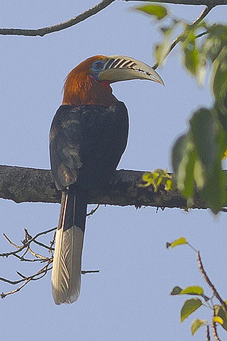
The rufous-necked hornbill is a species of hornbill in Bhutan, northeastern India, especially in Arunachal Pradesh, Indian Subcontinent and Southeast Asia. It is locally extinct in Nepal due to hunting and significant loss of habitat. There are less than 10,000 adults left in the wild. With a length of about 117 cm (46 in), it is among the largest Bucerotine hornbills. The underparts, neck and head are rich rufous in the male, but black in the female.

The Brahmaputra Valley semi-evergreen forests is a tropical moist broadleaf forest ecoregion of Northeastern India and southern Bhutan.

Namdapha National Park is a 1,985 km2 (766 sq mi) large protected area in Arunachal Pradesh of Northeast India. The park was established in 1983. With more than 1,000 floral and about 1,400 faunal species, it is a biodiversity hotspot in the Eastern Himalayas. The national park harbours the northernmost lowland evergreen rainforests in the world at 27°N latitude. It also harbours extensive dipterocarp forests, comprising the northwestern parts of the Mizoram-Manipur-Kachin rain forests ecoregion.

The Eastern Himalayan broadleaf forests is a temperate broadleaf forest ecoregion found in the middle elevations of the eastern Himalayas, including parts of Nepal, India, and Bhutan. These forests have an outstanding richness of wildlife.

Eaglenest or Eagle's Nest Wildlife Sanctuary is a protected area of India in the Himalayan foothills of West Kameng District, Arunachal Pradesh. It conjoins Sessa Orchid Sanctuary to the northeast and Pakhui Tiger Reserve across the Kameng river to the east. Altitude ranges are extreme: from 500 metres (1,640 ft) to 3,250 metres (10,663 ft). It is a part of the Kameng Elephant Reserve.

The Kameng River in the eastern Himalayan mountains, originates in Tawang district from the glacial lake below snow-capped Gori Chen mountain 27°48′36″N92°26′38″E, elevation 6,300 metres (20,669 ft), on the India-Tibet border and flows through Bhalukpong circle of West Kameng District, Arunachal Pradesh and Sonitpur District of Assam, India. It becomes a braided river in its lower reaches and is one of the major tributaries of the Brahmaputra River, joining it at Tezpur, just east of the Kolia Bhomora Setu bridge.

Sessa Orchid Sanctuary is a 100 km2 protected area of India in the Himalayan foothills in Bhalukpong Forest Division of West Kameng District, Arunachal Pradesh. It conjoins Eaglenest Wildlife Sanctuary to the southwest. It is a part of the Kameng Protected Area Complex (KPAC), which is an Elephant Reserve. See map. The department of Environment & Forests has developed trekking routes for visitors to enjoy the natural habitats of orchids. There are deep gorges and valleys, high peaks and rugged terrain that are rewarding for nature lovers and adventure tourists. A nursery includes representative specimens of various orchid species of the sanctuary and a demonstration farm of Cymbidium hybrids for cut-flower production. Most of Sessa has traditionally been claimed by the Bugun tribe as part of their territory.
Pakke Tiger Reserve, also known as Pakhui Tiger Reserve, is a Project Tiger reserve in the East Kameng district of Arunachal Pradesh in Northeast India. The 862 km2 (333 sq mi) reserve is protected by the Department of Environment and Forest of Arunachal Pradesh. In a notification (CWL/D/26/94/1393-1492) dated Itanagar 19 April 2001, issued by the Principal Secretary, the Governor of Arunachal Pradesh renamed Pakhui Wildlife Sanctuary as Pakke Wildlife Sanctuary Division.

Dehing Patkai National Park is located in the Dibrugarh and Tinsukia districts of Assam and covers an area of 231.65 km2 (89.44 sq mi) rainforest. It was declared a wildlife sanctuary on 13 June 2004. On 13 December 2020 Government of Assam upgraded it into a national park. On 9 June 2021 Forest Department of Assam officially notified it as a national park. It is located in the Dehing Patkai Landscape which is a dipterocarp-dominated lowland rainforest. The rainforest stretches for more than 575 km2 (222 sq mi) in the districts of Dibrugarh, Tinsukia and Charaideo. The forest further spreads over in the Tirap and Changlang districts of Arunachal Pradesh. Dehing Patkai National Park harbours the largest stretch of lowland rainforests in India. Dehing Patkai Wildlife Sanctuary was declared as Dehing Patkai Elephant Reserve under Project Elephant. Dehing-Patkai as a potential wildlife sanctuary was identified in late 1980s during a primate survey as "Upper Dehing Wildlife Sanctuary". Subsequently during a study on white-winged wood duck in early 1990s, it was discovered as a globally important site for this duck and recommended to be upgraded to "Upper Dehing National Park".

The Department of Environment and Forests of Arunachal Pradesh (DEFAP) is a state-sponsored agency responsible for conserving the environment, identifying, establishing, and conserving protected areas in the Indian state of Arunachal Pradesh.

Arunachal Pradesh is land of peanuts in the foothills of the Himalayas in northeast India. It is spread over an area of 83,743 km2 (32,333 sq mi). 98% of the geographical area is land out of which 80% is forest cover; 2% is water. River systems in the region, including those from the higher Himalayas and Patkoi and Arakan Ranges, eventually drain into the Brahmaputra River.

The Kamlang Wildlife Sanctuary, established in 1989, is the 50th Tiger reserve in India. The Sanctuary is rich with floral and faunal diversity. It is situated in the Lohit District of the northeastern Indian state of Arunachal Pradesh. The park is named after the Kamlang River which flows through it. The Mishmi, Digaro Mishmi, and Miju Mishmi people tribal people who reside around the periphery of the sanctuary claim their descent from the King Rukmo of the epic Mahabharata. They believe in a myth of an invisible god known as Suto Phenkhenynon jamalu. An important body of water in the sanctuary is the Glow Lake. Located in tropical and sub-tropical climatic zones, the sanctuary is the habitat of the four big cat species of India: tiger, leopard, clouded leopard and snow leopard.

The following outline is provided as an overview of and topical guide to Arunachal Pradesh:

Pakke-Kessang is a district located in the state of Arunachal Pradesh in the Northeast of India. The district used to be a part of the neighboring district, East Kameng, and was created out of its five southernmost administrative units: Pijerang, Passa Valley, Pakke-Kessang, Dissing Passo and Seijosa. The district headquarters of Pakke-Kessang is located at Lemmi.
Dehing Patkai Landscape, located in the Upper Assam, stretches for over roughly 600 square kilometres and comprises three large blocks of forests and several forest fragments. The forest is classified as a lowland Tropical Wet Evergreen Forest (Dipterocarpus-Mesua). It falls under Indo-Burma Biodiversity Hotspot. Due to its biodiversity and significance for elephant habitat, parts of the landscape are recognised as Dehing Patkai Elephant Reserve and 111 km2 is protected as the Dehing Patkai Wildlife Sanctuary since 2004.

Raimona National Park is located in extreme western part of Assam, India. It is spread across Gossaigaon and Kokrajhar subdivisions of Kokrajhar district of BTR.

The Mehao wildlife sanctuary was declared with an aim to conserve the biodiversity around the Mehao Lake. The sanctuary is gifted with virgin natural lush green forest and lakes. The sancturary harbours some rare varieties of orchids. The altitude of the sanctuary varies from 900 to 3500 meters. The sanctuary covers 281.5 km2 (108.7 sq mi). Its average winter temperature is 12 °C (54 °F) and its average summer temperature is 36 °C (97 °F).