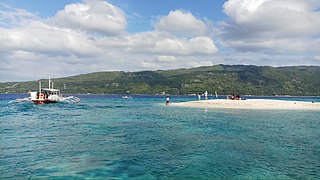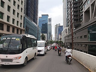
Barili, officially the Municipality of Barili, is a 2nd class municipality in the province of Cebu, Philippines. According to the 2020 census, it has a population of 80,715 people.

Dalaguete, officially the Municipality of Dalaguete, is a 1st class municipality in the province of Cebu, Philippines. According to the 2020 census, it has a population of 74,596 people.

Oslob, officially the Municipality of Oslob, is a 4th class municipality in the province of Cebu, Philippines. According to the 2020 census, it has a population of 29,264 people.

Tuburan, officially the Municipality of Tuburan, is a 2nd class municipality in the province of Cebu, Philippines. According to the 2020 census, it has a population of 68,167 people.

Libon, officially the Municipality of Libon, is a 1st class municipality in the province of Albay, Philippines. According to the 2020 census, it has a population of 75,073 people.

Malinao, officially the Municipality of Malinao, is a 3rd class municipality in the province of Albay, Philippines. According to the 2020 census, it has a population of 47,395 people.

San Luis, officially the Municipality of San Luis, is a 2nd class municipality in the province of Aurora, Philippines. According to the 2020 census, it has a population of 29,824 people.

The Cebu IT Park is a 27-hectare (67-acre) business park in Cebu City, Philippines. The park is envisioned to attract locators in the information technology industry. It is developed by Cebu Property Ventures and Development Corporation, a subsidiary of Cebu Holdings, Inc., in turn a wholly-owned subsidiary of Ayala Land.

Cebu Business Park (CBP) is a 50-hectare master-planned development in Cebu City, Cebu, Philippines. Cebu Holdings, an affiliate of Ayala Land, is currently responsible for the development of Cebu Business Park. Integrating business, residential, sports, recreation and leisure facilities, the centerpiece of the business park is the 9-hectare Ayala Center Cebu shopping mall, which draws 60,000 shoppers daily.

The Central Cebu Protected Landscape (CCPL) is a protected area located in the mountains and drainage basins of central Cebu in the Philippines.
Mount Lantoy is a 593-metre (1,946 ft) mountain located 10 kilometres (6.2 mi) inland from the municipality of Argao, Cebu in the Philippines.

The U.P.–Ayala Land TechnoHub is an information technology hub jointly developed by the University of the Philippines Diliman and property developer Ayala Land. It is located in Commonwealth Avenue, Barangay U.P. Campus, Quezon City. It occupies 20 hectares within the 37.5 hectares of the U.P. North Science and Technology Park.
Mount Manunggal is the third-highest peak in the island of Cebu after Osmena Peak and Lugsangan Peak. It is located in Barangay Magsaysay in Balamban, Cebu province, rising 982 m (3,222 ft) above sea level. It is the site of the crash of the presidential plane Mt. Pinatubo which killed President Ramon Magsaysay and twenty-four others on March 17, 1957.
Buhisan Dam is a dam located in Buhisan, Cebu City, Philippines. It is one of the main source of water for Cebu City and Metro Cebu. Part of Central Cebu Protected Landscape, Buhisan Dam is situated in the mountains of Barangay Buhisan behind Labangon, Cebu. Built in 1911-1912 and maintained by the Metro Cebu Water District, it is being developed into an eco-tourism location. It supplies five percent of Metropolitan Cebu Water District's (MCWD) current water capacity.
Guadalupe Mabugnao Mainit Hot Spring National Park is a protected area of the Philippines located in Barangay Guadalupe in Carcar, Cebu, some 50 kilometers from the provincial capital Cebu City. The park covers an area of 57.50 hectares occupying an important watershed forest reserve in the central Mantalongon mountain range. It was declared a national park in 1972 by virtue of Republic Act No. 6429.

The Upper Marikina River Basin Protected Landscape is a protected area in the Province of Rizal in the Philippines, which forms the upper area of the drainage basin of the Marikina River.
The Santa Lucia Protected Landscape, also known as the Salcedo Protected Landscape, is a protected area located in the foothills of the Cordillera Central mountain range in the Ilocos Sur province of the Philippines. It protects an important watershed that serves as the water source for the surrounding communities in the municipality of Salcedo. It had an initial area of 174 hectares proclaimed as the Santa Lucia Watershed Forest Reserve in 1938 through Proclamation No. 333 issued by President Manuel Luis Quezon. In 2000, the forest reserve was reestablished as a protected landscape area under the National Integrated Protected Areas System with the signing of Proclamation No. 296 by President Joseph Estrada.
The Maulawin Spring Protected Landscape is a protected landscape area of forested hills and several rivers and streams located in the province of Quezon on southern Luzon island in the Philippines. It was originally created in 1939 to protect the watershed in the municipality of Guinayangan known as the Maulawin Spring Watershed Forest Reserve declared through Proclamation No. 365 by President Manuel Luis Quezon. It had an initial area of 60 hectares. In 2000, the forest reserve was enlarged and was redesignated as a protected landscape under the National Integrated Protected Areas System by virtue of Proclamation No. 295 issued by President Joseph Estrada. It is the only source of potable water for domestic consumption of the more than 40,000 residents of Guinayangan.

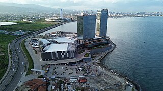
The South Road Properties (SRP), also known as the South Reclamation Project, is a 300 ha reclamation area in Cebu City, Philippines. The area, which is reclaimed from Mactan Channel, is located off the coast of the southern district of Cebu City, near Barangays Mambaling, Inayawan, and Pasil. It spans from the shore of mainland Cebu to Kawit Point. An island-type reclaimed area, it is connected with mainland Cebu by the Cebu South Coastal Road and the Mambaling Access Road. Through the Cebu–Cordova Link Expressway, the SRP is also connected by land to Cordova and the island of Mactan.

Prespa National Park is a national park situated in southeastern Albania on the border triangle shared with Greece and North Macedonia. At approximately 277.5 km2 (107.1 sq mi), the park encompasses the country's sections of the Great and Small Prespa Lake. It is considerably characterised by high mountains, narrow islands, vast freshwater wetlands, salt marshes, meadows, reed beds and dense forests.


