
Deoband is a town and a municipality in Saharanpur district in the state of Uttar Pradesh, India. Deoband is located about 150 km from Delhi.

Morigaon district (Pron:mʌrɪˈgãʊ) is an administrative district in the state of Assam in India. The district headquarters is located at Morigaon. The ancient place of occult Mayang is located in this district as well as Pobitora Wildlife Sanctuary.

Dharmavaram is a city in Anantapur district of the Indian state of Andhra Pradesh. It is the mandal and divisional headquarters of Dharmavaram mandal and Dharmavaram revenue division respectively. The city is known for its handloom silk sarees. The city is renowned for cotton, silk weaving industries and leather puppets. The city is called as Silk city of Andhra Pradesh.

Pakur district is one of the twenty-four districts of Jharkhand state, India, and Pakur is the administrative headquarters of this district. Pakur sub-division of Sahibganj district was carved out on 28 January 1994 to constitute Pakur District. The district, with a population of 900,422, and covering an area of 686.21 km², is situated on the north-eastern corner of Jharkhand state. The district is bounded on the north by Sahibganj district, on the south by Dumka district, on the west by Godda district, and on the east by the Murshidabad district of West Bengal.

Jhajjar district is one of the 22 districts of Haryana state in northern India. Carved out of Rohtak district on 15 July 1997 and with its headquarters in Jhajjar, it lies 29 kilometres (18 mi) from Delhi and had developed into an important industrial center. Other towns in the district are Bahadurgarh and Badli and Beri. Bahadurgarh is the major city of the district & state. Bahadurgarh is known as 'The City of Destiny'. Beri used to be a village fifty years ago.
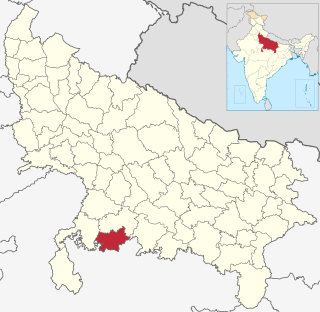
Mahoba district is one of the districts of Uttar Pradesh state of India and Mahoba town is the district headquarters. Mahoba district is a part of Chitrakoot Division. The district occupies an area of 2884 km². It has a population of 875,958. As of 2011 it is the least populous district of Uttar Pradesh. Mahoba District is also known as Alha-Udal Nagari.

Janjgir–Champa district is a district in the Indian state of Chhattisgarh. The district headquarters of the district Janjgir–Champa, Janjgir, is the city of Maharaja Jajawalya Dev of the Kalachuri dynasty. Earlier a part of the Bilaspur district, Jangir was carved out in 1998 to a separate district of its own, and ran to a political controversy about the name of the freshly minted district, which it carries to date as the name "Janjgir–Champa". Inhabitants are generally migrants from nearby villages.
Shimla is a district in the state of Himachal Pradesh in northern India. Its headquarters is the state capital of Shimla. Neighbouring districts are Mandi and Kullu in the north, Kinnaur in the east, Uttarakhand in the southeast, Solan to the southwest and Sirmaur in the south. The elevation of the district ranges from 987 metres (3,238 ft) to 4,500 metres (14,764 ft).

Bhiwadi is a city in Alwar district of Rajasthan state in India.

Mahalingpur or Mahalingapura in Kannada is a town of Bagalkot district in the Indian state of Karnataka. Agriculture, weaving and jaggery production are the primary industries here. In the past, town was called as Naragatti. Later renamed as Mahalingpur after the gracious appearance of Lord Shri Mahalingeshwara. People speak typical Kannada, understand English and Hindi. The town is known for its picturesque surroundings and pleasant climate. The Ghataprabha River flows through nearby Nandagaon village from its source, which lies to the southwest of the town, and in Kudala sangama gets merge with Krishna. Mahalingpur is one of the major commercial towns in the Bagalkot district. Jaggery and Saari's are common export marketing stuffs here.
Brij Nagar is town and tehsil in Bharatpur district in the Indian state of Rajasthan. It is situated equidistant among Bharatpur, Alwar & Mathura. Nagar is famous for the sweets called Jaleba, a bigger version of jalebi.

Nallur (Nalloor) is a panchayat town in Kanniyakumari district in the Indian state of Tamil Nadu.
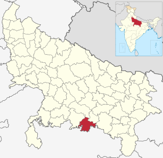
Chitrakoot district is one of the districts of Uttar Pradesh state of India in the Bundelkhand region and Chitrakoot town is the district headquarters. Chitrakoot district is a part of Chitrakoot Division. The district occupies an area of 3,216 km².The district has a population of 991,730. As of 2011 it is the second least populated district of Uttar Pradesh, after Mahoba.

Nagari is a town in Chittoor district of the Indian state of Andhra Pradesh. It is the mandal headquarters of Nagari mandal in Chittoor revenue division.

Chirakkal is a census town in Kannur district in the state of Kerala, India. It is a suburb of Kannur city of about 7 km away.

North Delhi is an administrative district of the National Capital Territory of Delhi in India. Alipur is the administrative headquarters of this district. North Delhi is bounded by the Yamuna River on the east and by the districts of North West Delhi to the north and west, West Delhi to the southwest, Central Delhi to the south, and North East Delhi to the east across the Yamuna. North Delhi has a population of 887,978, and an area of 59 km², with a population density of 13,019 people per km².
Kanaganapalle is a village in the Anantapur district of Andhra Pradesh. It is the headquarters of a Dharmavaram revenue division mandal.
Bukkapatnam is a village in Anantapur district of the Indian state of Andhra Pradesh. It is the headquarters of Bukkapatnam mandal in Kadiri revenue division.
Eyyal is a village in Thrissur District in the state of Kerala, India. Archeologists have unearthed a collection of old Roman coins in 1946. These coins date from 123 BC to 117 AD. These coins currently exhibited in the Archeological Museum of Thrissur.
Dhanora, commonly known as "Dhanora Motya" is a village located in Purna taluka of Parbhani district, in the state of Maharashtra, India.