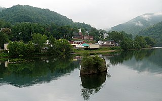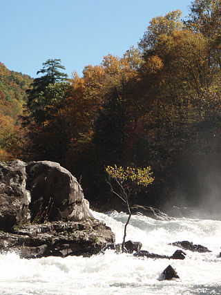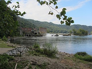
Gauley Bridge is a town in Fayette County, West Virginia, United States. The population was 614 at the 2010 census. The Kanawha River is formed at Gauley Bridge by the confluence of the New and Gauley Rivers. Two miles to the southwest of Gauley Bridge, in Glen Ferris, is Kanawha Falls, a popular stopping point on Midland Trail Scenic Highway.

The Deschutes River in central Oregon is a major tributary of the Columbia River. The river provides much of the drainage on the eastern side of the Cascade Range in Oregon, gathering many of the tributaries that descend from the drier, eastern flank of the mountains. The Deschutes provided an important route to and from the Columbia for Native Americans for thousands of years, and then in the 19th century for pioneers on the Oregon Trail. The river flows mostly through rugged and arid country, and its valley provides a cultural heart for central Oregon. Today the river supplies water for irrigation and is popular in the summer for whitewater rafting and fishing.

The New River is a river which flows through the U.S. states of North Carolina, Virginia, and West Virginia before joining with the Gauley River to form the Kanawha River at the town of Gauley Bridge, West Virginia. Part of the Ohio River watershed, it is about 360 miles (580 km) long.

The Kanawha River is a tributary of the Ohio River, approximately 97 mi (156 km) long, in the U.S. state of West Virginia. The largest inland waterway in West Virginia, its watershed has been a significant industrial region of the state since early in the 19th century.

The Little Kanawha River is a tributary of the Ohio River, 169 mi (269 km) long, in western West Virginia in the United States. Via the Ohio, it is part of the watershed of the Mississippi River, draining an area of 2,320 mi2 (6,009 km2) on the unglaciated portion of the Allegheny Plateau. It served as an important commercial water route in the early history of West Virginia, particularly in the logging and petroleum industries.

Lees Ferry is a site on the Colorado River in Coconino County, Arizona in the United States, about 7.5 miles (12.1 km) southwest of Page and 9 miles (14 km) south of the Utah–Arizona state line.
The Little Nestucca River is a river, approximately 20 miles (32 km) long, on the Pacific coast of northwest Oregon in the United States. It drains an area of the Central Oregon Coast Range west of the Willamette Valley.

The Patapsco River mainstem is a 39-mile (63 km) river in central Maryland that flows into the Chesapeake Bay. The river's tidal portion forms the harbor for the city of Baltimore. With its South Branch, the Patapsco forms the northern border of Howard County, Maryland. The name "Patapsco" is derived from the Algonquian pota-psk-ut, which translates to "backwater" or "tide covered with froth".

The New River Gorge National Park and Preserve is a unit of the United States National Park Service designed to protect and maintain the New River Gorge in southern West Virginia in the Appalachian Mountains. Established in 1978 as a national river and redesignated in 2020, the park and preserve stretches for 53 miles (85 km) from just downstream of Hinton to Hawks Nest State Park near Ansted.

The Gauley River is a 105-mile-long (169 km) river in West Virginia. It merges with the New River to form the Kanawha River, a tributary of the Ohio River. The river features numerous recreational whitewater areas, including those in Gauley River National Recreation Area downstream of the Summersville Dam.

The Elk River is a tributary of the Kanawha River, 172 miles (277 km) long, in central West Virginia in the United States. Via the Kanawha and Ohio rivers, it is part of the watershed of the Mississippi River.

Shavers Fork of the Cheat River is situated in the Allegheny Mountains of eastern West Virginia, USA. It is 88.5 mi (142.4 km) long and forms the Cheat at its confluence with Black Fork at Parsons. It was traditionally considered one of the five Forks of Cheat and its upper reaches constitute the highest river in the eastern United States.

The Williams River is a tributary of the Gauley River, 33 miles (53 km) long, in east-central West Virginia, USA. Via the Gauley, Kanawha and Ohio Rivers, it is part of the watershed of the Mississippi River, draining an area of 132 square miles (342 km2) in a sparsely populated region of the southern Allegheny Mountains and the unglaciated portion of the Allegheny Plateau.

The Cranberry River is a tributary of the Gauley River located in southeastern West Virginia in the United States. It is a part of the Mississippi River watershed, by way of the Gauley, Kanawha, and Ohio Rivers, draining an area of 74 square miles (192 km2).

Great Falls is a series of rapids and waterfalls on the Potomac River, 14 miles (23 km) upstream from Washington, D.C., on the border of Montgomery County, Maryland and Fairfax County, Virginia. The Potomac and the falls themselves are legally entirely within Maryland, since the state's border follows the south bank of the river.

The Vermillion River is a 59.6-mile (95.9 km) waterway that meanders through Scott County and Dakota County in Minnesota, entering the Mississippi River floodplain just south of Hastings. 13.5 miles (21.7 km) of it are designated as a trout stream, which is unusual for being so close to a metropolitan area. Trophy-sized trout used to be found in the river often but not much anymore.

Glen Ferris is a census-designated place (CDP) on the western bank of the Kanawha River in Fayette County, West Virginia, United States. It is situated approximately one mile south of the town of Gauley Bridge and adjacent to Kanawha Falls. The sole highway linking Glen Ferris to the area is U.S. Route 60, known also as the Midland Trail. As of the 2010 census, its population was 203; the community had 104 housing units, 87 of which were occupied. The village is roughly a mile and a half in length. Glen Ferris is home to two churches, one Apostolic and one Methodist. A railway owned by Norfolk Southern runs parallel to US Route 60 through the village.
Swiss is an unincorporated community in western Nicholas County, West Virginia, United States. Its elevation is 735 ft (224 m).
Kanawha Falls is an unincorporated community in Fayette County, West Virginia, United States. Kanawha Falls is located on the east bank of the Kanawha River, 2 miles (3.2 km) southwest of Gauley Bridge and 0.6 miles (0.97 km) downstream from the waterfall of the same name. Kanawha Falls had a post office, which opened on March 26, 1856, and closed on November 2, 2002.
Big Sandy Creek is a 31.3-mile-long (50.4 km) mountain stream which begins in Fayette County, Pennsylvania, and flows into Preston County, West Virginia, in the United States. The Big Sandy flows through Bruceton Mills and Rockville, West Virginia, before crashing down the mountainside and reaching its confluence with the Cheat River at the abandoned town of Jenkinsburg.


