
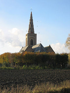
Kanegem is a Belgian locality, part of the municipality of Tielt, in the eastern part of the province of West Flanders. This rural locality is known as the "Green Village".
Kanegem is a Belgian locality, part of the municipality of Tielt, in the eastern part of the province of West Flanders. This rural locality is known as the "Green Village".
Coordinates: 51°01′N3°24′E / 51.017°N 3.400°E
| This West Flanders location article is a stub. You can help Wikipedia by expanding it. |

The geography of France consists of a terrain that is mostly flat plains or gently rolling hills in the north and west and mountainous in the south and the east. Metropolitan France has a total size of 551,695 km2 (213,011 sq mi). It is the third largest country in Europe after Russia and Ukraine.
Oudekapelle is a small village in the Belgian province of West-Flanders and a part ("deelgemeente") of the municipality of Diksmuide. Oudekapelle is a small village with only about ten houses around the church and farms on its territory. It has about 150 inhabitants.

Knokke is a town in the municipality of Knokke-Heist, which is located in the province of West Flanders in Flanders, Belgium. The town itself has 15,708 inhabitants (2007), while the municipality of Knokke-Heist has 33,818 inhabitants (2009).

Kemble is a village and civil parish in the Cotswold District of Gloucestershire, England. Historically part of Wiltshire, it lies 4 miles (6.4 km) from Cirencester and is the settlement closest to Thames Head, the source of the River Thames. At the 2011 census it had a population of 1,036.
An administrative centre is a seat of regional administration or local government, or a county town, or the place where the central administration of a commune is located.

Wąchock(

Arthuret is a civil parish in the Carlisle district of Cumbria, England. According to the 2001 census it had a population of 2,434, increasing to 2,471 at the 2011 Census. The parish includes the small town of Longtown and the village of Easton. It is bounded by the River Esk to the west and the River Lyne to the south.
Olshanka is a rural locality in Chernyansky District of Belgorod Oblast, Russia.
Sosnovka is the name of several inhabited localities in Russia.
Eernegem is a town in the Ichtegem municipality, in the province of West Flanders in Belgium.

This is a list of the extreme points of Azerbaijan, the points that are farther north, south, east or west than any other location.
Progress is the name of several inhabited localities in Russia.
Talitsa is the name of several inhabited localities in Russia.

Llanellen is a village in Monmouthshire, south-east Wales, United Kingdom. It is located three miles (4.8 km) south of Abergavenny. The population was 506 in 2011.

The Roman Catholic Diocese of Ghent, also known as (Ghent) or (Gand); is a diocese of the Latin Church of the Roman Catholic Church in Belgium. The patron of the diocese is Saint Bavo of Ghent
Chegdomyn is an urban locality and the administrative center of Verkhnebureinsky District of Khabarovsk Krai, Russia. Population: 13,048 (2010 Census); 15,303 (2002 Census); 20,347 (1989 Census).
Yershov or Yershova is the name of several inhabited localities in Russia.

Perkpolder is a hamlet in the southwestern Netherlands, situated in the municipality of Hulst, Zeeland. It is known as a departure point for the ferry Kruiningen-Perkpolder that connected Zuid-Beveland and Zeelandic Flanders.
Andreyevsky, Andreyevskaya, or Andreyevskoye is the name of several rural localities in Russia.