North Korea is located in East Asia in the Northern half of Korea, partially on the Korean Peninsula. It borders three countries: China along the Yalu (Amnok) River, Russia along the Tumen River, and South Korea to the south.

Pyongyang is the capital and largest city of North Korea, where it is sometimes labeled as the "Capital of the Revolution". Pyongyang is located on the Taedong River about 109 km (68 mi) upstream from its mouth on the Yellow Sea. According to the 2008 population census, it has a population of 3,255,288. Pyongyang is a directly administered city with a status equal to that of the North Korean provinces.

North Hwanghae Province is a province of North Korea. The province was formed in 1954 when the former Hwanghae Province was split into North and South Hwanghae. The provincial capital is Sariwon. The province is bordered by Pyongyang and South Pyongan to the north, Kangwon to the east, Kaesong Industrial Region and South Korea's Gyeonggi Province to the south, and South Hwanghae southwest. In 2003, Kaesong Directly Governed City became part of North Hwanghae as Kaepung County. Later on in 2019, it was promoted as Special City. Thus, it was separated from North Hwanghae.
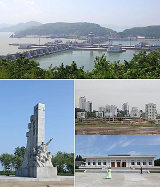
Nampo, also spelled Namp'o, is a city in North Korea which is the country's fourth-largest by population. The city is an important seaport in the country as it lies on the northern shore of the Taedong River, 15 km east of the river's mouth. Formerly known as Chinnamp'o, it was a provincial-level "Directly Governed City" ("Chikhalsi") from 1980 to 2004, and was designated a "Special City" in 2010. Nampo is approximately 50 km southwest of Pyongyang, at the mouth of the Taedong River. Since North Korean independence, the city has developed a wide range of industry and has seen significant recent redevelopment.

The Taedong River (Korean: 대동강) is a large river in North Korea. The river rises in the Rangrim Mountains of the country's north where it then flows southwest into Korea Bay at Namp'o. In between, it runs through the country's capital, Pyongyang. Along the river are landmarks such as the Juche Tower and Kim Il-sung Square.

Pyongsong is a city in North Korea, the capital city of South Pyongan province in western North Korea. The city is located about 32 kilometres northeast of Pyongyang, and was formally established in December 1969. It has a population of 284,386.
Sangwŏn County is a county of North Hwanghae, formerly one of the four suburban counties located in east P'yŏngyang, North Korea. Prior to 1952, Sangwŏn was merely a township of Chunghwa County. In 1952 it was separated as a separate county, and in 1963 it was added as a county of Pyongyang. It is north of North Hwanghae's Hwangju, Yŏntan, and Suan counties, south of the Nam River and Kangdong county west of Yŏnsan county, and east of Chunghwa county. In 2010, it was administratively reassigned from P'yŏngyang to North Hwanghae; foreign media attributed the change as an attempt to relieve shortages in P'yŏngyang's food distribution system.

Sunch'ŏn is a city in South Pyongan province, North Korea. It has a population of 297,317, and is home to various manufacturing plants. The city is on the Taedong River.
Gangnam or Kangnam may refer to:

Kop'ung County is a kun, or county, in Chagang province, North Korea. Prior to the division of Korea, it was part of Chosan county.

Ch'osan County is a kun, or county, in Chagang province, North Korea. It borders the People's Republic of China to the north.

Changsŏng County is a kun, or county, in northern North Phyŏngan province, North Korea. It is bordered by Pyŏktong to the east, Tongchang and Taegwan to the south, Sakchu to the west; to the north, it faces China across the Yalu (Amrok) River.
Sakju County is a kun, or county, in northern part of North P'yŏngan province, in North Korea. It lies along the Yalu River bordering the People's Republic of China to the north. Within North Korea, it borders Ch'angsŏng to the east, Ch'ŏnma and Taegwan to the south, and Ŭiju to the west.
Chunghwa County is a county of North Hwanghae, formerly one of the four suburban counties of East Pyongyang, North Korea. It sits north of Hwangju-gun, North Hwanghae, east of Kangnam-gun, North Hwanghae, west of Sangwŏn-gun, North Hwanghae, and south of Ryŏkp'o-guyŏk, Pyongyang. It became part of Pyongyang in May 1963, when it separated from South P'yŏngan Province. Chunghwa-gun is the location of a few historic sights, such as the Chunghwa Hyanggyo, as well as a few KPA weapons units. In 2010, it was administratively reassigned from Pyongyang to North Hwanghae; foreign media attributed the change as an attempt to relieve shortages in Pyongyang's food distribution system.

Moranbong-guyŏk (Korean: 모란봉구역), or the Moranbong District, is one of the 18 guyŏk which constitute the capital city of Pyongyang, North Korea. It is located north of Chung-guyok, the city's central district, and is bordered to the north by Sosong and Taesong-guyoks, to the east by the Taedong River, and the west by the Pothonggang Canal and Potonggang-guyok. It is named after Moran Hill, located in the district's west area – Moran. It was designated a guyŏk in October 1960 by the Pyongyang City People's Committee.

Sŏn'gyo-guyŏk or Songyo District is one of the 18 guyŏk that constitute the city of Pyongyang, North Korea. It is on the eastern bank of the Taedong River at the center of East Pyongyang. It is bordered to the south by Nakrang-guyok, to the north by Tongdaewon-guyok and to the east by Ryokpo and Sadong-guyoks. It was established in September 1959.
Sŭngho or Sŭngho-gun is a county of North Hwanghae Province, North Korea. It was formerly one of the 19 kuyŏk that constitute P'yŏngyang, but in 2010, it was administratively reassigned from P'yŏngyang to North Hwanghae; foreign media attributed the change as an attempt to relieve shortages in P'yŏngyang's food distribution system.

Rangrang-guyŏk or Rangrang District is one of the 18 kuyŏk that constitute the city of Pyongyang, North Korea. It is located south of the Taedong River, and is bordered to the north by Songyo-guyok, to the east by the Ryokpo-guyok, and to the south by Chunghwa and Kangnam counties.
Ssuk Islet is a small island in the Taedong River in Pyongyang, North Korea, separated by a shallow channel from the larger Turu Island to its west. Since 1983 it has been accessible by road via an off-ramp in the middle of the Chungsong Bridge. It is the site of the new Pyongyang Sci-Tech Complex completed in 2015.