Orogeny is a mountain-building process that takes place at a convergent plate margin when plate motion compresses the margin. An orogenic belt or orogen develops as the compressed plate crumples and is uplifted to form one or more mountain ranges. This involves a series of geological processes collectively called orogenesis. These include both structural deformation of existing continental crust and the creation of new continental crust through volcanism. Magma rising in the orogen carries less dense material upwards while leaving more dense material behind, resulting in compositional differentiation of Earth's lithosphere. A synorogenic process or event is one that occurs during an orogeny.

Victoria is an Australian state, situated at the southern end of the Great Dividing Range. The Great Dividing Range stretches along the east coast of the continent and terminates near the Victorian city of Ballarat west of the capital Melbourne, though the nearby Grampians may be considered to be the final part of the range. The highest mountains in Victoria are the Victorian Alps, located in the northeast of the state.

Baltica is a paleocontinent that formed in the Paleoproterozoic and now constitutes northwestern Eurasia, or Europe north of the Trans-European Suture Zone and west of the Ural Mountains. The thick core of Baltica, the East European Craton, is more than three billion years old and formed part of the Rodinia supercontinent at c. 1 Ga.

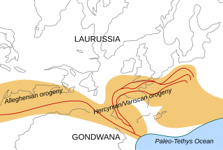
The Variscan or Hercynianorogeny was a geologic mountain-building event caused by Late Paleozoic continental collision between Euramerica (Laurussia) and Gondwana to form the supercontinent of Pangaea.
The Uralian orogeny refers to the long series of linear deformation and mountain building events that raised the Ural Mountains, starting in the Late Carboniferous and Permian periods of the Palaeozoic Era, c. 323–299 and 299–251 million years ago (Mya) respectively, and ending with the last series of continental collisions in Triassic to early Jurassic times.

A geosyncline is an obsolete geological concept to explain orogens, which was developed in the late 19th and early 20th centuries, before the theory of plate tectonics was envisaged. A geosyncline was described as a giant downward fold in the Earth's crust, with associated upward folds called geanticlines, that preceded the climax phase of orogenic deformation.

The geology of Australia includes virtually all known rock types, spanning a geological time period of over 3.8 billion years, including some of the oldest rocks on earth. Australia is a continent situated on the Indo-Australian Plate.
The Hunter-Bowen Orogeny was a significant arc accretion event in the Permian and Triassic periods affecting approximately 2,500 km of the Australian continental margin.

The Trans-Hudson orogeny or Trans-Hudsonian orogeny was the major mountain building event (orogeny) that formed the Precambrian Canadian Shield and the North American Craton, forging the initial North American continent. It gave rise to the Trans-Hudson orogen (THO), or Trans-Hudson Orogen Transect (THOT), which is the largest Paleoproterozoic orogenic belt in the world. It consists of a network of belts that were formed by Proterozoic crustal accretion and the collision of pre-existing Archean continents. The event occurred 2.0–1.8 billion years ago.
The Lachlan Fold Belt (LFB) or Lachlan Orogen is a geological subdivision of the east part of Australia. It is a zone of folded and faulted rocks of similar age. It dominates New South Wales and Victoria, also extending into Tasmania, the Australian Capital Territory and Queensland. It was formed in the Middle Paleozoic from 450 to 340 Mya. It was earlier known as Lachlan Geosyncline. It covers an area of 200,000 km2.
The Narooma Accretionary Complex or Narooma Terrane is a geological structural region on the south coast of New South Wales, Australia that is the remains of a subduction zone or an oceanic terrane. It can be found on the surface around Narooma, Batemans Bay and down south into Victoria near Mallacoota. It has attached itself to the Lachlan Fold Belt and has been considered as either an exotic terrane or as a part of the fold belt. Rocks are turbidites, block in matrix mélange, chert, and volcanics. The accretionary complex itself could either be the toe of a subduction zone, or an accretionary prism. It was moved by the Pacific Plate westwards for about 2500 km until it encountered the east coast of Gondwana. It is part of the Mallacoota Zone according to Willman, which in turn is part of the Eastern Lachlan Fold Belt, which is part of the Benambra Terrane.

Gondwana was a large landmass, sometimes referred to as a supercontinent. The remnants of Gondwana make up around two-thirds of today's continental area, including South America, Africa, Antarctica, Australia, Zealandia, Arabia, and the Indian Subcontinent. The other contemporary supercontinent at this time was Laurasia, both having broken off Pangaea.

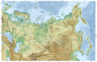
The geology of Russia, the world's largest country, which extends over much of northern Eurasia, consists of several stable cratons and sedimentary platforms bounded by orogenic (mountain) belts.
Geologically the Australian state of New South Wales consists of seven main regions: Lachlan Fold Belt, the Hunter-Bowen Orogeny or New England Orogen (NEO), the Delamerian Orogeny, the Clarence Moreton Basin, the Great Artesian Basin, the Sydney Basin, and the Murray Basin.

The geology of Queensland can be subdivided into several regions with different histories. Along the east coast is a complex of Palaezoic to Cainozoic rocks while much of the rest of the state is covered by Cretaceous and Cainozoic rocks. A Precambrian basement is found in the north west and Cape York regions. The Thomson Orogen occurs in the central and southern parts of Queensland, but is mostly covered by younger basins.

The Famatinian orogeny is an orogeny that predates the rise of the Andes and that took place in what is now western South America during the Paleozoic, leading to the formation of the Famatinian orogen also known as the Famatinian belt. The Famatinian orogeny lasted from the Late Cambrian to at least the Late Devonian and possibly the Early Carboniferous, with orogenic activity peaking about 490 to 460 million years ago. The orogeny involved metamorphism and deformation in the crust and the eruption and intrusion of magma along a Famatinian magmatic arc that formed a chain of volcanoes. The igneous rocks of the Famatinian magmatic arc are of calc-alkaline character and include gabbros, tonalites, granodiorites and trondhjemites. The youngest igneous rocks of the arc are granites.

The Terra Australis Orogen (TAO) was a late Neoproterozoic- to Paleozoic-age accretionary orogen that ringed the ancient, active southern margin of the supercontinents Rodinia and later Pannotia. This vast orogenic belt stretched for c. 18,000 km (11,000 mi) along-strike and involved, from west to east, landmasses belonging to the modern-day Andean margin of South America, the South African Cape, West Antarctica, Victoria Land in East Antarctica, Eastern Australia, Tasmania, and New Zealand. The formation of the Terra Australis Orogen is associated with the breakup of Rodinia at the end of the Neoproterozoic Era and the creation of Panthalassa, the paleo-Pacific Ocean, and it was succeeded by the Gondwanide orogeny with the formation of the supercontinent Pangea in the middle Paleozoic Era.

The geology of Germany is heavily influenced by several phases of orogeny in the Paleozoic and the Cenozoic, by sedimentation in shelf seas and epicontinental seas and on plains in the Permian and Mesozoic as well as by the Quaternary glaciations.
The Tuhua orogeny was a regional orogeny between 370 and 330 million years ago, now preserved in the Fiordland region of New Zealand. Early Paleozoic rocks such as Ordovician greywacke, slate and paragneiss in the Buller terrane, weakly metamorphosed greenschist and sub-greenschist rocks, Cambrian mafic volcanics, Ordovician limestone and Silurian clastic rocks were all deformed and metamorphosed. In addition, between 380 and 250 million years ago, metasediments reached amphibolite grade in the sequence of metamorphic facies.


