Kansangui

Last updated
Kansangui
Sub-prefecture and town
Guinea adm location map.svg
Red pog.svg
Kansangui
Location in Guinea
Coordinates: 11°12′N11°36′W / 11.200°N 11.600°W / 11.200; -11.600
CountryFlag of Guinea.svg  Guinea
Region Labé Region
Prefecture Tougué Prefecture
Time zone GMT (UTC+0)

Kansangui is a town and sub-prefecture in the Tougué Prefecture in the Labé Region of northern-central Guinea. [1]

Town settlement that is bigger than a village but smaller than a city

A town is a human settlement. Towns are generally larger than villages but smaller than cities, though the criteria to distinguish them vary considerably between different parts of the world.

Sub-prefectures of Guinea

The sub-prefectures are the third-level administrative divisions in Guinea. As of 2009 there were 303 rural sub-prefectures of Guinea and 38 urban sub-prefectures, 5 of which compose the Conakry greater urban area; Kaloum, Dixinn, Matam, Ratoma and Matoto.

Tougué Prefecture Prefecture in Labé Region, Guinea

Tougué is a prefecture located in the Labé Region of Guinea. The capital is Tougué. The prefecture covers an area of 6,400 km². and has an estimated population of 132,000.

Related Research Articles

Boké Region Region in Guinea

The Boké Region is located in western Guinea. It is bordered by the countries of Senegal and Guinea-Bissau and the Guinean regions of Kindia and Labé. Its capital is the city of Boké.

Lélouma Prefecture Prefecture in Labé Region, Guinea

Lélouma is a prefecture located in the Labé Region of Guinea. The capital is Lélouma. The prefecture covers an area of 2,140 km.² In census of 2014, it had population of 163,000.

Koubia Prefecture Prefecture in Labé Region, Guinea

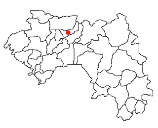
Koubia is a prefecture located in the Labé Region of Guinea in the Fouta Djallon mountains. Fulas are the majority ethnic group in the region with Fula (Pular) as the primary language. The capital is Koubia. The prefecture covers an area of 2,800 km.² and has an estimated population of 114,000.

Labé Prefecture Prefecture in Labé Region, Guinea

Labé is a prefecture in the Labé Region of Guinea. The capital is Labé. The prefecture covers an area of 3,014 km.² and has an estimated population of 204,000.

Boffa Prefecture Prefecture in Boké Region, Guinea

Boffa is a prefecture located in the Boké Region of Guinea. The capital is Boffa. The prefecture covers an area of 5,050 km2 (1,950 sq mi) and has a population of 212,583.

Dinguiraye Prefecture Prefecture in Faranah Region, Guinea

Dinguiraye is a prefecture located in the Faranah Region of Guinea. The capital is Dinguiraye. The prefecture covers an area of 7,965 km.² and has a population of 195,662.

Dabola Prefecture Prefecture in Faranah Region, Guinea

Dabola is a prefecture located in the Faranah Region of Guinea. The capital is Dabola. The prefecture covers an area of 6,350 km.² and has an estimated population of 182,951.

Siguiri Prefecture Prefecture in Kankan Region, Guinea

Siguiri is a prefecture located in the Kankan Region of Guinea. The capital is Siguiri. The prefecture covers an area of 18,500 km2 (7,100 sq mi) and has a population of 687,002.

Labé Region Region in Guinea

The Labé Region is located in north-central Guinea. It is bordered by the countries of Senegal and Mali and the Guinean regions of Faranah, Kindia, Mamou, and Boké.

Gaoual Sub-prefecture and town in Boké Region, Guinea

Gaoual is a town located in northwestern Guinea. It is the capital of Gaoual Prefecture. As of 2014 it had a population of 20,582 people.

Kobikoro Sub-prefecture and town in Faranah Region, Guinea

Kobikoro is a town and sub-prefecture in the Faranah Prefecture in the Faranah Region of Guinea. As of 2014 it had a population of 13,912 people.

Baguinet Sub-prefecture and town in Boké Region, Guinea

Baguinet is a town and sub-prefecture in the Fria Prefecture in the Boké Region of western Guinea. As of 2014 it had a population of 13,839 people.

Fangamadou Sub-prefecture and town in Nzérékoré Region, Guinea

Fangamadou is a town and sub-prefecture in the Guéckédou Prefecture in the Nzérékoré Region of south-western Guinea.

Tyanguel-Bori Sub-prefecture and town in Labé Region, Guinea

Tyanguel-Bori is a town and sub-prefecture in the Lélouma Prefecture in the Labé Region of northern-central Guinea.

Balizia Sub-prefecture and town in Nzérékoré Region, Guinea

Balizia is a town and sub-prefecture in the Macenta Prefecture in the Nzérékoré Region of south-eastern Guinea.

Sansando Sub-prefecture and town in Kankan Region, Guinea

Sansando is a town and sub-prefecture in the Mandiana Prefecture in the Kankan Region of eastern Guinea. As of 2014 it had a population of 23,018 people.

Kintinian Sub-prefecture and town in Kankan Region, Guinea

Kintinian is a town and sub-prefecture in the Siguiri Prefecture in the Kankan Region of northern Guinea.

Missira, Kindia Sub-prefecture and town in Kindia Region, Guinea

Missira, Kindia is a town and sub-prefecture in the Télimélé Prefecture in the Kindia Region of western-central Guinea.

Noussy Sub-prefecture and town in Labé Region, Guinea

Noussy is a town and sub-prefecture in the Labé Prefecture in the Labé Region of northern-central Guinea.

References

  1. "Subprefectures of Guinea". Statoids. Retrieved April 20, 2009.

Coordinates: 11°12′N11°36′W / 11.200°N 11.600°W / 11.200; -11.600

Geographic coordinate system Coordinate system

A geographic coordinate system is a coordinate system that enables every location on Earth to be specified by a set of numbers, letters or symbols. The coordinates are often chosen such that one of the numbers represents a vertical position and two or three of the numbers represent a horizontal position; alternatively, a geographic position may be expressed in a combined three-dimensional Cartesian vector. A common choice of coordinates is latitude, longitude and elevation. To specify a location on a plane requires a map projection.